This item has been sold, but you can get on the Waitlist to be notified if another example becomes available, or purchase a digital scan.
1716 Homann Map of Scandinavia During the Great Northern War
Scandinavia-homann-1716$500.00

Title
Scandinavia complectens Sueciae, Daniae et Norvegiae Regna ex tabula Joh Bapistae Homanni.
1716 (undated) 19 x 22.5 in (48.26 x 57.15 cm) 1 : 4200000
1716 (undated) 19 x 22.5 in (48.26 x 57.15 cm) 1 : 4200000
Description
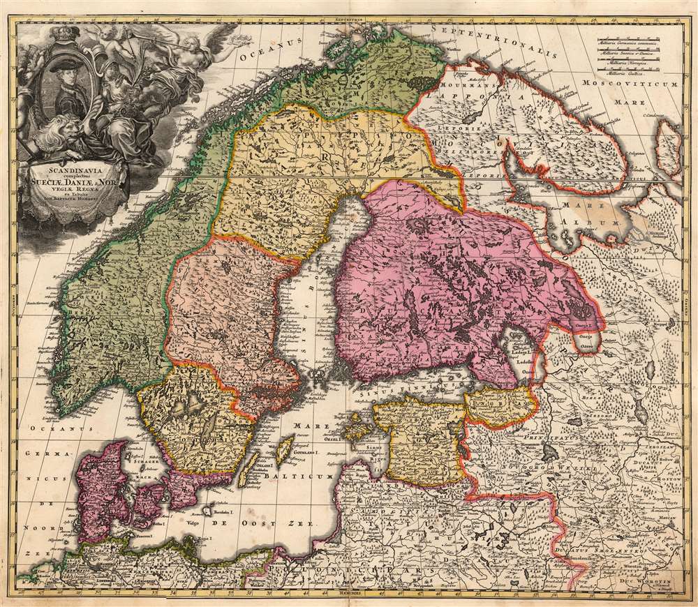
This is Johann Baptist Homann's 1716 map of Scandinavia, bringing the dominant 17th century mapping of the northern parts of Europe up-to-date with the events of the Great Northern War (1700 - 1721). The map is based primarily on Anders Bure's 1626 mapping of the region, which became the state of the art of the mapping of Scandinavia and was replaced as an authority for more than a century. In this regard, Bure is hailed as the Father of Swedish Cartography. The scope of the map includes Denmark, Norway, the greater Swedish Empire, the Baltic coasts of Germany, Poland and Livonia, and the Russian Empire - including 'Lapponia Moscovitica,' the portions of Lapland occupied by Russia.
Moreover, the waters are muddied by the existence of no fewer than seven maps, printed from six different plates, all with the same title, all attributed to Homann (although several of these appear to be pirated maps, copying the Homann down to its Imperial Privilege). The earliest credible date we associate with one of these is 1711. An example of that map in the same, first state appears in a 1716 Homann atlas. A second state of that same plate, with a re-worked cartouche, appears in a different atlas bearing the same date (both atlases appear in the collection of David Rumsey). The present map is an example of what we believe to be the second state of the first plate. Of the six further plates based on this map, the earliest credible date is 1721. The map would appear to be well represented in institutional collections, but given the pig's breakfast presented by the inconsistent cataloging, it is impossible, short of the examination of each cataloged example in person, to determine the prevalence of one plate over another.
The Great Northern War
This map was produced during the 1700 - 1721 Great Northern War between Sweden and Russia. It captures a period in which Sweden was losing ground in the conflict - particularly in the region of the Gulf of Finland, and the city of St. Petersburg. The dotted, engraved border between Russian and Swedish territory is preserved here from (most likely) De Wit's 1680 Novissima nec non Perfectissima Scandinaviae, which showed the extent of Sweden's acquisitions as of 1654. But the original wash and outline color here highlights areas which were, at best, contested - and many of which were, by the time this map was published, securely Russian. Livonia, Ingria, and parts of Karelia are here no longer Swedish, and although surrounded and colored in the red associated with Swedish Finland on the map, the newly-founded city of Petersburg is clearly marked. Despite early victories in the Northern War, by the time this map was published there was little to be celebrated by the Swedes. In 1709, Charles suffered his greatest defeat at the hands of Peter the Great: the Battle of Poltava. This was a defeat from which Charles would never recover, a reality not lost on the mapmaker.The Allegorical Cartouche
The title cartouche in the upper left is beautifully engraved, but presents the celebrated King of Sweden in the midst of his fall. The young king appears centrally in a portrait, with battle scenes and fortifications faintly in the background. A lion, one of the heraldic symbols for Sweden, lies at the foot of the portrait. In its mouth is a laurel - the symbol of victory - wilting. To the left, a helmeted figure - Ares, the god of War - can be seen removing more laurels from the portrait frame. A putto reaches up towards the crown surmounting the frame, indicating imminent loss. The goddess of victory - Nike - flies away, holding her victory laurel away from the King. Seated beside the portrait, with veiled hair, an incense burner, and a palm branch is a mournful-looking figure (possibly Chastity). Charles XII never married and fathered no known children: in an 18th century monarch, this represented more of a problem than a virtue. When Charles was shot and killed during the Siege of Fredriksten on December 11, 1718, his sister Ulrika assumed the throne, but was unable to maintain the absolute rule her father established, and her brother maintained. The war with Russia ended soon after.Publication History and Census
The cataloging of this map is wildly inconsistent in terms of its dating. Many libraries list it with a date of 1702, despite the clear presence of the St. Petersburg. This is not credible: in 1703 Peter and Paul Fortress was only just laid down. Tsar Peter moved the capital from Moscow to Saint Petersburg in 1712, and the very first plan of the city was not published until 1717.Moreover, the waters are muddied by the existence of no fewer than seven maps, printed from six different plates, all with the same title, all attributed to Homann (although several of these appear to be pirated maps, copying the Homann down to its Imperial Privilege). The earliest credible date we associate with one of these is 1711. An example of that map in the same, first state appears in a 1716 Homann atlas. A second state of that same plate, with a re-worked cartouche, appears in a different atlas bearing the same date (both atlases appear in the collection of David Rumsey). The present map is an example of what we believe to be the second state of the first plate. Of the six further plates based on this map, the earliest credible date is 1721. The map would appear to be well represented in institutional collections, but given the pig's breakfast presented by the inconsistent cataloging, it is impossible, short of the examination of each cataloged example in person, to determine the prevalence of one plate over another.
CartographerS
Johann Baptist Homann (March 20, 1664 - July 1, 1724) was the most prominent and prolific map publisher of the 18th century. Homann was born in Oberkammlach, a small town near Kammlach, Bavaria, Germany. As a young man, Homann studied in a Jesuit school and nursed ambitions of becoming a Dominican priest. Nonetheless, he converted to Protestantism in 1687, when he was 23. It is not clear where he mastered engraving, but we believe it may have been in Amsterdam. Homann's earliest work we have identified is about 1689, and already exhibits a high degree of mastery. Around 1691, Homann moved to Nuremberg and registered as a notary. By this time, he was already making maps, and very good ones at that. He produced a map of the environs of Nürnberg in 1691/92, which suggests he was already a master engraver. Around 1693, Homann briefly relocated to Vienna, where he lived and studied printing and copper plate engraving until 1695. Until 1702, he worked in Nuremberg in the map trade under Jacob von Sandrart (1630 - 1708) and then David Funck (1642 - 1709). Afterward, he returned to Nuremberg, where, in 1702, he founded the commercial publishing firm that would bear his name. In the next five years, Homann produced hundreds of maps and developed a distinctive style characterized by heavy, detailed engraving, elaborate allegorical cartouche work, and vivid hand color. Due to the lower cost of printing in Germany, the Homann firm could undercut the dominant French and Dutch publishing houses while matching their diversity and quality. Despite copious output, Homann did not release his first major atlas until the 33-map Neuer Atlas of 1707, followed by a 60-map edition of 1710. By 1715, Homann's rising star caught the attention of the Holy Roman Emperor Charles VI, who appointed him Imperial Cartographer. In the same year, he was also appointed a member of the Royal Academy of Sciences in Berlin. Homann's prestigious title came with several significant advantages, including access to the most up-to-date cartographic information as well as the 'Privilege'. The Privilege was a type of early copyright offered to very few by the Holy Roman Emperor. Though less sophisticated than modern copyright legislation, the Privilege offered limited protection for several years. Most all J. B. Homann maps printed between 1715 and 1730 bear the inscription 'Cum Priviligio' or some variation. Following Homann's death in 1724, the firm's map plates and management passed to his son, Johann Christoph Homann (1703 - 1730). J. C. Homann, perhaps realizing that he would not long survive his father, stipulated in his will that the company would be inherited by his two head managers, Johann Georg Ebersberger (1695 - 1760) and Johann Michael Franz (1700 - 1761), and that it would publish only under the name 'Homann Heirs'. This designation, in various forms (Homannsche Heirs, Heritiers de Homann, Lat Homannianos Herod, Homannschen Erben, etc.) appears on maps from about 1731 onwards. The firm continued to publish maps in ever-diminishing quantities until the death of its last owner, Christoph Franz Fembo (1781 - 1848). More by this mapmaker...
Anders Bure (August 14, 1571 - February 4, 1646) was a Swedish mathematician and cartographer. He is considered the father of Swedish cartography. He was the son of the parish priest Engelbertus Laurentii and Elisabeth Andersdotter Burea, descendant of the long-established Bureätten family. His immediate family included diplomats and government officials. His education is obscure, though he is mentioned as an office clerk in 1602. His duties in the following years involved recording royal genealogical and historical works, involving him in the highest echelons of Swedish society. He also participated in diplomatic assignments, including missions to both Russia and Finland. His cartographic contributions improved the mapping both of the northern parts of Sweden, and the kingdom as a whole. His six-sheet 1626 Orbis Arctoi represented the first real improvement to the mapping of the northern parts of Europe since the Olaus Magnus map of the previous century: this map would provide the basis for virtually every European map of Scandinavia to follow in the 17th century. In addition to these achievements, he was the first person recorded to use the decimal system in Sweden. Learn More...
Source
Homann, J. B., Neuer Atlas bestehend in einig curieusen Astronomischen Kuppren und vielen auserlesenen accuratensten Land-Charten über die Gantze Welt, (Nuremberg: Homann), 1716.
Homann's Neuer Atlas bestehend in einig curieusen Astronomischen Kuppren und vielen auserlesenen accuratensten Land-Charten über die Gantze Welt was first publihsed in 1707 with 33 maps. A second edition followed in 1710 with 60 maps. Subsequent editions followed until about 1730. The title page notes proudly that the atlas features measurements based on the 'Copernican principle of the moving sky', a truly state-of-the-art innovation for the period. Regardless of editions, collations of the atlas are inconsistent, with some examples having less, while others have more maps - a consequence of the fact that the map sheets were delivered loose, to be bound at the buyer's discretion, and so some buyers chose to omit maps they did not consider relevant, or add others they did. Between editions, the constituent maps, particularly of European regions, were regularly updated to reflect the most recent political events. The atlas continued to be published by Homann's son, J. C. Homann (1703 - 1730), and then by Homann Heirs. Most examples also feature a fine allegorical frontispiece with the title Atlas Novus Terrarum Orbis Imperia, regna et Status, which was used for multiple Homann atlases, including the Neuer Atlas and the Atlas Minor.
Condition
Very good. Scuffing at bottom centerfold. Stain in the area of the White Sea. Reinforced with old paper at time of binding. Rich original wash color and a bold, sharp strike.
References
OCLC 941331904. Rumsey 12499.191.