1724 Homann Map of Scandinavia Following the Great Northern War
Scandinavia-homann-1724$850.00

Title
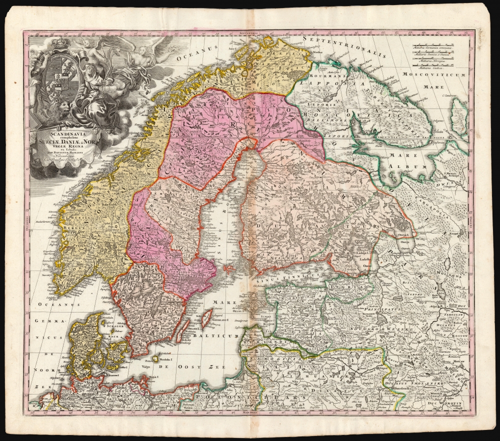
Scandinavia complectens Sueciae, Daniae et Norvegiae Regna ex tabula Joh Bapistae Homanni Norimbergae Cum Privilegio Sac. Caes. Maj.
1724 (undated) 19 x 22.5 in (48.26 x 57.15 cm) 1 : 4200000
1724 (undated) 19 x 22.5 in (48.26 x 57.15 cm) 1 : 4200000
Description
This is Johann Baptist Homann's map of Scandinavia, bringing the dominant 17th-century mapping of the northern parts of Europe up-to-date with the events of the Great Northern War (1700 - 1721). The map is based primarily on Anders Bure's 1626 mapping of the region - the authority for more than a century. The political borders reflect the state of affairs following the disastrous Great Northern War with Russia.
A Closer Look
The scope of the map includes Denmark, Norway, the greater Swedish Empire, the Baltic coasts of Germany, Poland, and Livonia, and the Russian Empire - including 'Lapponia Moscovitica,' the portions of Lapland occupied by Russia. St. Petersburg is named, and while the region of Carelia just north of it is tinted to reflect Swedish territory, the outline border in green extends into that territory from Pitis to Soma, indicating Russian control over that area.The Great Northern War
This map was produced after Great Northern War (1700 - 1721), fought between Sweden and Russia. It captured a period in which Sweden was losing ground - particularly in the Gulf of Finland and St. Petersburg. The dotted, engraved border between Russian and Swedish territory is preserved here from (most likely) De Wit's 1680 Novissima nec non Perfectissima Scandinaviae, which showed the extent of Sweden's acquisitions as of 1654.The Allegorical Cartouche
The title cartouche in the upper left is beautifully engraved but has been edited: the medallion once containing the portrait of King Charles XII has been replaced with the coat of arms of Frederik I, who took the throne on March 24, 1720, following the abdication of his wife, Charles XII's sister, who had taken the throne after her brother's death at the 1718 Siege of Fredriksten. The allegorical features of the cartouche, aimed at the late king, were equally applicable to his successors. A lion, one of the heraldic symbols for Sweden, lies at the foot of the portrait. In its mouth is a laurel - the symbol of victory - wilting. To the left, a helmeted figure - Ares, the god of War - is removing laurels from the portrait frame. A putto reaches up towards the crown surmounting the frame, indicating imminent loss. The goddess of victory - Nike - flies away, holding her victory laurel away from the king. Seated beside the portrait, with veiled hair, an incense burner, and a palm branch, is a mournful-looking figure (possibly Chastity). Charles XII never married and fathered no known children: in an 18th-century monarch, this represented more of a problem than a virtue. When Charles was shot and killed during the Siege of Fredriksten, his sister Ulrika assumed the throne, but was unable to maintain absolute rule. The war with Russia ended soon after, and it fell to Frederik I to swallow the inevitable results of the conflict.Publication History and Census
The cataloging of this map is wildly inconsistent in terms of its dating; there was more than one plate, and multiple states of those. No date earlier than 1712 for the first plate is possible, owing to the clear presence of St. Petersburg. The earliest credible date for this printing - a second plate entirely - is 1721, but we are inclined to think it to have been one of the younger Homann's maps re-engraved after the death of Johann Baptist Homann, probably 1724. The map is well represented in institutional collections, but given inconsistent cataloging, it is impossible, short of the examination of each cataloged example in person, to determine the prevalence of one plate over another.CartographerS
Johann Baptist Homann (March 20, 1664 - July 1, 1724) was the most prominent and prolific map publisher of the 18th century. Homann was born in Oberkammlach, a small town near Kammlach, Bavaria, Germany. As a young man, Homann studied in a Jesuit school and nursed ambitions of becoming a Dominican priest. Nonetheless, he converted to Protestantism in 1687, when he was 23. It is not clear where he mastered engraving, but we believe it may have been in Amsterdam. Homann's earliest work we have identified is about 1689, and already exhibits a high degree of mastery. Around 1691, Homann moved to Nuremberg and registered as a notary. By this time, he was already making maps, and very good ones at that. He produced a map of the environs of Nürnberg in 1691/92, which suggests he was already a master engraver. Around 1693, Homann briefly relocated to Vienna, where he lived and studied printing and copper plate engraving until 1695. Until 1702, he worked in Nuremberg in the map trade under Jacob von Sandrart (1630 - 1708) and then David Funck (1642 - 1709). Afterward, he returned to Nuremberg, where, in 1702, he founded the commercial publishing firm that would bear his name. In the next five years, Homann produced hundreds of maps and developed a distinctive style characterized by heavy, detailed engraving, elaborate allegorical cartouche work, and vivid hand color. Due to the lower cost of printing in Germany, the Homann firm could undercut the dominant French and Dutch publishing houses while matching their diversity and quality. Despite copious output, Homann did not release his first major atlas until the 33-map Neuer Atlas of 1707, followed by a 60-map edition of 1710. By 1715, Homann's rising star caught the attention of the Holy Roman Emperor Charles VI, who appointed him Imperial Cartographer. In the same year, he was also appointed a member of the Royal Academy of Sciences in Berlin. Homann's prestigious title came with several significant advantages, including access to the most up-to-date cartographic information as well as the 'Privilege'. The Privilege was a type of early copyright offered to very few by the Holy Roman Emperor. Though less sophisticated than modern copyright legislation, the Privilege offered limited protection for several years. Most all J. B. Homann maps printed between 1715 and 1730 bear the inscription 'Cum Priviligio' or some variation. Following Homann's death in 1724, the firm's map plates and management passed to his son, Johann Christoph Homann (1703 - 1730). J. C. Homann, perhaps realizing that he would not long survive his father, stipulated in his will that the company would be inherited by his two head managers, Johann Georg Ebersberger (1695 - 1760) and Johann Michael Franz (1700 - 1761), and that it would publish only under the name 'Homann Heirs'. This designation, in various forms (Homannsche Heirs, Heritiers de Homann, Lat Homannianos Herod, Homannschen Erben, etc.) appears on maps from about 1731 onwards. The firm continued to publish maps in ever-diminishing quantities until the death of its last owner, Christoph Franz Fembo (1781 - 1848). More by this mapmaker...
Anders Bure (August 14, 1571 - February 4, 1646) was a Swedish mathematician and cartographer. He is considered the father of Swedish cartography. He was the son of the parish priest Engelbertus Laurentii and Elisabeth Andersdotter Burea, descendant of the long-established Bureätten family. His immediate family included diplomats and government officials. His education is obscure, though he is mentioned as an office clerk in 1602. His duties in the following years involved recording royal genealogical and historical works, involving him in the highest echelons of Swedish society. He also participated in diplomatic assignments, including missions to both Russia and Finland. His cartographic contributions improved the mapping both of the northern parts of Sweden, and the kingdom as a whole. His six-sheet 1626 Orbis Arctoi represented the first real improvement to the mapping of the northern parts of Europe since the Olaus Magnus map of the previous century: this map would provide the basis for virtually every European map of Scandinavia to follow in the 17th century. In addition to these achievements, he was the first person recorded to use the decimal system in Sweden. Learn More...
Condition
Good. Stain at centerfold.
References
OCLC 1063244491. Not in Rumsey.