This item has been sold, but you can get on the Waitlist to be notified if another example becomes available, or purchase a digital scan.
1662 Blaeu Map of the Kingdom of Scotland
Scotland-blaeu-1662$187.50

Title
Scotia Regnum cum insulis adjacentibus.
1662 (undated) 17 x 22 in (43.18 x 55.88 cm) 1 : 1400000
1662 (undated) 17 x 22 in (43.18 x 55.88 cm) 1 : 1400000
Description
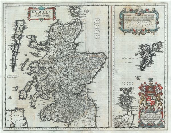
This is a beautiful map of the Kingdom of Scotland by Joan Blaeu in 1662. Essentially divided into two panels within a single border, the panel on the left depicts Scotland from its southern border to Orkney Islands, including the Outer Hebrides and the right panel depicts the Orkney Islands and the Shetland Islands. Numerous towns, cities, rivers and other topography is noted throughout, with relief shown in profile.
This map was first published by Blaeu in the first atlas dedicated to Scotland published in 1654 and is based on the surveys of Robert Gordon of Straloch, who Blaeu called the 'Doyen of Geographers.' Prior to the surveys of Robert Gordon, mapmakers were dependent on the earlier maps of Gerard Mercator, whose map were the standard for more than sixty years before the work of Robert Gordon was published under Blaeu's sponsorship. Blaeu went on to publish an atlas dedicated to Scotland, which included general and county maps based on the work of Robert Gordon and Timothy Pont.
Two beautifully engraved title cartouches are included in each panel. The coat of arms of Jacob Hamilton, to whom this map is dedicated, in included in the bottom right quadrant. This map was issued in the 1662 Latin edition of Blaeu's magnificent Geographiae Blavianae or Atlas Major.
Cartographer
Joan (Johannes) Blaeu (September 23, 1596 - December 21, 1673) was a Dutch cartographer active in the 17th century. Joan was the son of Willem Janszoon Blaeu, founder of the Blaeu firm. Like his father Willem, Johannes was born in Alkmaar, North Holland. He studied Law, attaining a doctorate, before moving to Amsterdam to join the family mapmaking business. In 1633, Willem arranged for Johannes to take over Hessel Gerritsz's position as the official chartmaker of the Dutch East India Company, although little is known of his work for that organization, which was by contract and oath secretive. What is known is his work supplying the fabulously wealthy VOC with charts was exceedingly profitable. Where other cartographers often fell into financial ruin, the Blaeu firm thrived. It was most likely those profits that allowed the firm to publish the Theatrum Orbis Terrarum, sive, Atlas Novus, their most significant and best-known publication. When Willem Blaeu died in 1638, Johannes, along with his brother Cornelius Blaeu (1616 - 1648) took over the management of the Blaeu firm. In 1662, Joan and Cornelius produced a vastly expanded and updated work, the Atlas Maior, whose handful of editions ranged from 9 to an astonishing 12 volumes. Under the brothers' capable management, the firm continued to prosper until the 1672 Great Amsterdam Fire destroyed their offices and most of their printing plates. Johannes Blaeu, witnessing the destruction of his life's work, died in despondence the following year. He is buried in the Dutch Reformist cemetery of Westerkerk. Johannes Blaeu was survived by his son, also Johannes but commonly called Joan II, who inherited the family's VOC contract, for whom he compiled maps until 1712. More by this mapmaker...
Source
Blaeu J., Geographiae Blavianae, (Amsterdam: Blaeu) 1662.
Condition
Good. Some wear and repair with minor portions missing along original centerfold. Professionally flattened and backed with archival tissue.
References
Peter van der Krogt, Joan Blaeu Atlas Maior of 1665 Pg. 190, 191. Goss, J. & Clark P., Blaeu - Der grobe Atlas: die Welt im 17. Jahrhundert, pg. 84, 85, (Vienna) 1990.