This item has been sold, but you can get on the Waitlist to be notified if another example becomes available, or purchase a digital scan.
1794 Campbell Map of Scotland
Scotland-campbell-1794$700.00

Title
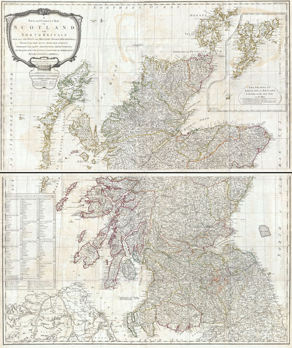
A New and Correct Map of Scotland or North Britain with all the Post and Military Roads, Divisions, and ca.
1794 (dated) 50 x 42 in (127 x 106.68 cm)
1794 (dated) 50 x 42 in (127 x 106.68 cm)
Description
An absolutely stunning and monumental 1794 wall map of Scotland by Lieutenant Campbell. Covers Scotland in full with extraordinary detail throughout. Notes every town, hamlet, bishopric, country, forest, castle swam and road. Even offers some offshore detail with regard to the various postal ferries, the Marrs Bank, rocks and other undersea dangers, and cod fishing grounds. Identifies a number of important locales including Loch Ness, the source of the Spey, Ben Wyvis mountain, the Rock of Islay, Ben Nivis Mountain, and the ruins of Beregonium ancient capital of Scotland. A large inset map in the upper right quadrant details the Shetland Islands. An elaborate baroque title cartouche appears in the upper left quadrant. Published by Laurie and Whittle as plate nos. 7-8 in the 1797 edition of Thomas Kitchin's General Atlas.
CartographerS
Duncan Campbell (fl. 1750 - 1800) was an Scottish cartographer and surveyor employed with the British Admiralty. Campbell has proven to be an elusive figure, however, "Lieutenant Campbell" as he is referred to on his famous map of Scotland, may in face refer to Duncan Campbell, who was associated with both the Admiralty and the British Post system. More by this mapmaker...
Laurie and Whittle (fl. 1794 - 1858) were London, England, based map and atlas publishers active in the late 18th and early 19th century. Generally considered to be the successors to the Robert Sayer firm, Laurie and Whittle was founded by Robert Laurie (c. 1755 - 1836) and James Whittle (1757-1818). Robert Laurie was a skilled mezzotint engraver and is known to have worked with Robert Sayer on numerous projects. James Whittle was a well-known London socialite and print seller whose Fleet Street shop was a popular haunt for intellectual luminaries. The partnership began taking over the general management of Sayer's firm around 1787; however, they did not alter the Sayer imprint until after Sayer's death in 1794. Apparently Laurie did most of the work in managing the firm and hence his name appeared first in the "Laurie and Whittle" imprint. Together Laurie and Whittle published numerous maps and atlases, often bringing in other important cartographers of the day, including Kitchin, Faden, Jefferys and others to update and modify their existing Sayer plates. Robert Laurie retired in 1812, leaving the day to day management of the firm to his son, Richard Holmes Laurie (1777 - 1858). Under R. H. Laurie and James Whittle, the firm renamed itself "Whittle and Laurie". Whittle himself died six years later in 1818, and thereafter the firm continued under the imprint of "R. H. Laurie". After R. H. Laurie's death the publishing house and its printing stock came under control of Alexander George Findlay, who had long been associated with Laurie and Whittle. Since, Laurie and Whittle has passed through numerous permeations, with part of the firm still extant as an English publisher of maritime or nautical charts, 'Imray, Laurie, Norie and Wilson Ltd.' The firm remains the oldest surviving chart publisher in Europe. Learn More...
Thomas Kitchin (August 4, 1718 – June 23, 1784) was a London based engraver, cartographer, and publisher. He was born in London to a hat-dyer of the same name. At 14, Kitchin apprenticed under Emanuel Bowen, under whom he mastered the art of engraving. He married Bowen daughter, Sarah Bowen, and later inherited much of his preceptor's prosperous business. Their son, Thomas Bowen Kitchin, also an engraver joined the family business, which thereafter published in Thomas Kitchin and Son. From 1858 or so Kitchin was the engraver to the Duke of York, and from about 1773 acquired the title, 'Royal Hydrographer to King George III.' He is responsible for numerous maps published in the The Star, Gentleman's Magazine, and London Magazine, as well as partnering with, at various times, with Thomas Jefferys, Emmanuel Bowen, Thomas Hinton, Issac Tayor, Andrew Dury, John Rocque, Louis de la Rochette, and Alexander Hogg, among others. Kitchin passed his business on to his son, Thomas Bowen Kitchin, who continued to republish many of his maps well after his death. Kitchin's apprentices included George Rollos, Bryant Lodge, Thomas Bowen Kitchin, Samuel Turner Sparrow, John Page, and Francis Vivares. Learn More...
Source
Kitchin, Thomas, Kitchin's General Atlas, describing the Whole Universe: being a complete collection of the most approved maps extant; corrected with the greatest care, and augmented from the last edition of D'Anville and Robert with many improvements by other eminent geographers, engraved on Sixty-Two plates, comprising Thirty Seven maps., Laurie & Whittle, London, 1797.
Condition
Very good condition. On four sheets, top two sheets jointed by publisher, bottom two sheets joined by publisher. Top section and bottom section are unjoined, but can be joined upon request from buyer. These also framed quite dramatically separately. Original folds exhibit some wear and minor verso repair and reinforcement. Platemark visible. Blank on verso. Size indicated is for the entire map, joined. Individual sheets are half as tall.
References
Rumsey 0411.011, 0411.012, 0411.013, 2310.013, 2310.014, 2310.015. Phillips (Atlases) 4300. National Maritime Museum, 375 (3rd ed. 1801).