This item has been sold, but you can get on the Waitlist to be notified if another example becomes available, or purchase a digital scan.
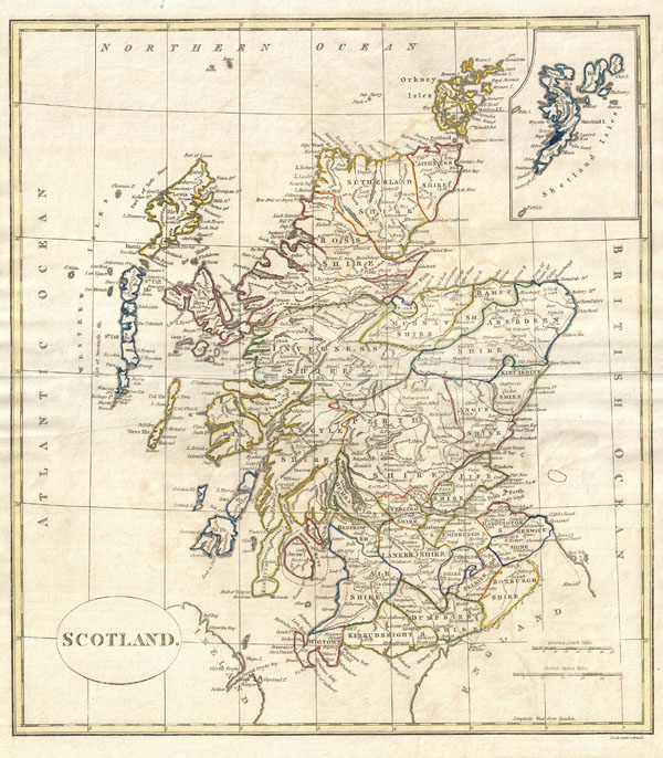
1799 Clement Cruttwell Map of Scotland
Scotland-cruttwell-1799$100.00

Title
Scotland.
1799 (dated) 16 x 14 in (40.64 x 35.56 cm)
1799 (dated) 16 x 14 in (40.64 x 35.56 cm)
Description
A fine 1799 map of Scotland by the English map publisher Clement Cruttwell. Covers the entire region in great detail, including a detailed inset of the Shetland Isles. Here all the counties are labeled as Shires, as the word 'county' did not become common usage in Scotland until the nineteenth century. In the north are Caithness, Sutherland, Ross, Murray, Aberdeen, and Bamff Shires. With the exception of the merger of Ross Shire and Cromarty Shire, these counties are still in existence today. In central Scotland are the Inverness Shire, Kincardine Shire, Angus Shire, Argyle Shire, Fife Shire and Perth Shire. Further south are the Shires of Renfew, Dumbarton, Edinburgh, Haddington, Berwick, Lanerk, Air, Kirkudbright, Dumfries, Selkirk, and Roxburgh. Lewis Island, in the North, is attached to Rofs Shire. South of Lewis Island is North and South Uist Island, and Coll Island, which retained baronial fief by the Macleans of Coll until 1848. In the northeast are the Shetland Islands, which did not officially become a part of Scotland until a Scottish Act of Parliament in 1669. The map is highly detailed, including many roads, river ways, ports, towns and shoals. Outline color and fine copper plate engraving in the minimalist English style prevalent in the late 18th and early 19th centuries. Mountains and other topographical detail shown by profile. Drawn by G. G. and J. Robinson of Paternoster Row, London, for Clement Cruttwell's 1799 Atlas to Cruttwell's Gazetteer.
Cartographer
Clement Cruttwell (1743 - August 5, 1808) was an English book and map publisher active in Bath and London in the late 18th and early 19th century. Cruttwell was born the son of William Cruttwell, a gentleman of Wokingham, Berkshire, England. As a young man Cruttwell was educated to be an Anglican Reverend and consequently maintained a lifelong interest in religious matters. Throughout his life, he published a number of religious works and geographical gazetteers including several focused on the British Isles and one dedicated to France. Though little is known of Cruttwell today, he was highly regarded in his own time. In his obituary, a period publication, The Universal Magazine of Knowledge and Pleasure describes Cruttwell as
a gentleman whose various literary performances, for labour, extent, and utility, have rarely been equaled, and, when regarded as the productions of an unassisted valetudinarian, have perhaps never been surpassed.Cruttwell was also a known correspondent of George Washington to whom he sent his own translation of the Holy Bible, which Washington kept in his personal library until his death. More by this mapmaker...
Source
Cruttwell, C., Atlas to Cruttwell's Gazetteer, 1799.
Condition
Very good. Original centerfold. Platemark visible. Some offsetting. Moderate overall toning. Blank on verso.