This item has been sold, but you can get on the Waitlist to be notified if another example becomes available, or purchase a digital scan.
1921 Evans Map of the Scott Antarctic Expedition of 1910-1913
ScottExpedition-evans-1921$175.00

Title
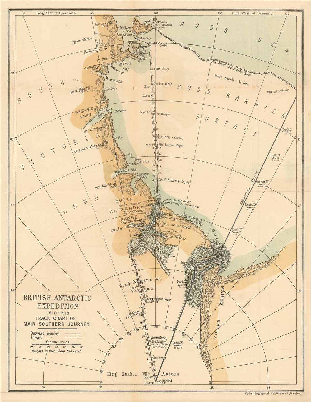
British Antarctic Expedition 1910-1913 Track Chart of Main Southern Journey.
1921 (undated) 15 x 11.75 in (38.1 x 29.845 cm) 1 : 3850000
1921 (undated) 15 x 11.75 in (38.1 x 29.845 cm) 1 : 3850000
Description
This 1921 map of the Ross Ice Shelf and the South Pole was included in Edward R.G.R. Evans' firsthand account of the ill-fated 1910-1913 Scott expedition to reach the Pole. The entire route of the journey is shown, marked with dates informed by Scott's own diaries. The final resting places of expedition members Evans, Oates, Scott, Wilson and Bowers are marked on the map. In a poignant addition, the route of the Norwegian Expedition under Amundsen -which beat Scott to the pole - is shown as well.
The British Antarctic Expedition
Also known as the Terra Nova expedition, this was a 1910-1913 expedition to Antarctica led by Robert Falcon Scott to be the first to reach the geographic South Pole. He and four companions attained the pole on January 17 1912, only to find that Amundsen's Norwegian team receded them by 34 days. Scott's party died on the return journey from the pole; some of their bodies, journals, and photographs were found by a search party eight months later.Publication History and Census
This map appeared as an insert in Captain Edward R.G.R. Evans' 'South With Scott', which is well represented in institutional collections.Cartographer
Edward Ratcliffe Garth Russell Evans, 1st Baron Mountevans, KCB, DSO, SGM (October 28, 1880 – August 20, 1957), was a British naval officer and Antarctic explorer. He served as a crewman on the Discovery Expedition of the Antarctic in 1901–04, and was second-in-command on Robert Falcon Scott's ill-fated expedition to the South Pole in 1910–1913, as captain of the expedition ship Terra Nova. He accompanied Scott to within 150 miles of the Pole, but later became seriously ill with scurvy and only narrowly survived the return journey. He toured extensively giving lectures on the expedition, and published a 1921 firsthand account of the expedition with Scott. He spent the First World War as a destroyer captain, commanded a cruiser at Hong Kong in 1921–22, and was awarded command of the modern battlecruiser HMS Repulse. He later served as Civil Defence Commissioner for London during the preparations for the Second World War. More by this mapmaker...
Source
Evans, Captain Edward R.G.R. 'South With Scott' (Collins, London) 1921.
Condition
Very good, with some wear at juncture of folds.
References
cfOCLC 987811