
1946 Onativia Pictorial Map of Basque Country, Spain

This item has been sold.
Carta ilustrada del M.N. y M.L. Señorío de Vizcaya.
Euskal Herria.
Choose a Collection:
- Digital Map Information
- Suitable for large format printing
- File Size: 55.45 MB
- File Type: ZIP / TIFF
- ICC color profile embedded
- Delivered instantly via download link
This Item
Enquire
Euskal Herria.
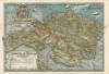
A richly illustrated c. 1957 pictorial map of the province of Biscay in Basque Country by Gregorio Hombrados Oñativia. Intricately detailed, it is a remarkable chronicle of Basque culture, history, and geography.A Closer Look
The entirety of Biscay (Vizcaya), including its enclaves (parts of Santander) and exclave (Orduna), is presented. The province is based on the territory of the historic Lordship (Señorío) of Biscay, whose coat of arms appears at top-left. A tremendous amount of information is included, as reflected by the highly detailed legend below the title.In addition to cities and villages (including Bilbao near center), railroads, roads of various types and quality, mountains, rivers, and other elements, even gas stations and public telephones, are noted. Illustrations depict settlements, industries, landmarks, famous inhabitants, sports and leisure activities, and other local characteristics. Vignettes around the margins of the map represent neighboring provinces, including the Basque regions of Álava and Guipúzcoa.
Although meant to highlight and celebrate Basque culture, it is notable that the language used is Spanish, reflecting official suppression of the Basque language under the Francoist regime.
Publication History and Census
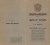
This map was drawn by Gregorio Hombrados Oñativia using a distinctive 'difuminograbado' process, which appears to be a combination of etching and lithography. It was printed by Gráficas Laborde y Labayen in Tolosa and sponsored by the Banco de Bilbao. The date of 1946 appears in faint print below the scale, part of a larger string of text that appears to have been erased or stricken from the original print. Although listed five times in the OCLC, only four institutions (the University of Arizona, the University of Kansas, the Biblioteca Nacional de España, and the University of Liverpool) are noted as holding physical examples.Condition
Very good. Light wear along original fold lines. Stray ink from printing and other minor imperfections in margins.
References
OCLC 1076615109, 25116277, 431772833.