This item has been sold, but you can get on the Waitlist to be notified if another example becomes available, or purchase a digital scan.
1581 Ortelius Map of Seville, Andalusia
Seville-ortelius-1579$225.00

Title
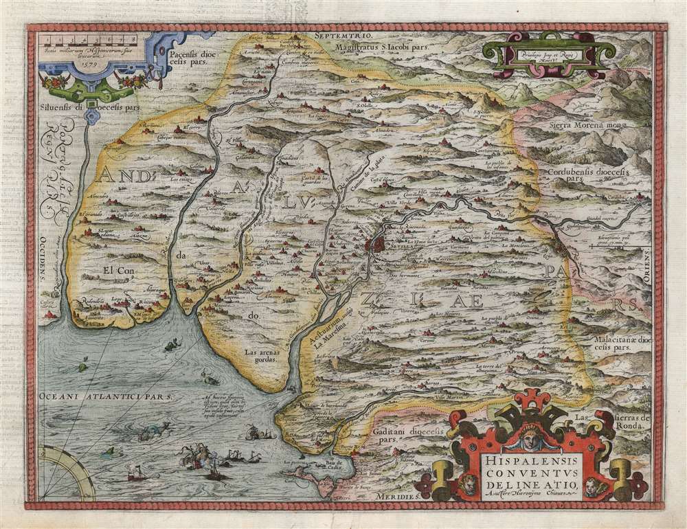
Hispalensis Conventus Delineatio Auctore Hieronÿmo Chiaves.
1579 (dated) 13.75 x 18 in (34.925 x 45.72 cm) 1 : 600000
1579 (dated) 13.75 x 18 in (34.925 x 45.72 cm) 1 : 600000
Description
This is an attractive, first state example of Abraham Ortelius' 1581 map of Seville and its surroundings, Andalusia, Spain. This map details the most crucial home ports of the Spanish Empire, based on the report of Geronimo de Chavez, the chief geographer of Spain's Casa de Contratación at the peak of its power. It centers on a pictorial representation of the walled city of Seville and its cathedral on the Guadalquivir River. The vital port and city of Cadiz, home port of the Spanish treasure fleet, appears at bottom center. The region's mountainous terrain is dramatically and artfully depicted. Off the coast of Cadiz a sea battle rages, while hungry sea monsters prowl the waters.
The Region and the Source
Beginning in 1503, Seville was the home of the Casa de Contratación, which was Spain's bureaucracy tasked with administering the Empire's sprawling overseas holdings. It had broad powers over any overseas matters, ranging from trade disputes, probates of Spaniards dying abroad, the training of navigators, the collection of colonial taxes, and the creation of maps and charts. Through its control of the Padrón Real (the master map and template for all Spanish charts produced during the 16th century) the Casa was the single clearinghouse of Spanish geographical knowledge, all of which was held a close secret by the Empire. Nevertheless, the vast array of officials, cartographers, engravers, and draftsmen needed for this task meant that secrets inevitably leaked. Also, from time-to-time geographical information would be deliberately disseminated to map publishers within the Empire - in particular, to Antwerp, where engravers of sufficient skill for map printing could be found. The chief cartographer of the Casa beginning in 1552, Geronimo de Chavez (1523 - 1574), was responsible for the publication of a number of crucial maps both of Spanish regions and her overseas territories. After his death, many of these were printed in Ortelius' atlas, including this one.Publication History and Census
This map was engraved for inclusion in Abraham Ortelius' Theatrum Orbis Terrarum. It remained in the atlas with minor changes throughout the long print run of that work. This specific example is the first state - in 1595, the ocean area was re-engraved with stippling. The French verso text conforms to the 1581 edition Theatrum. The map appears on the market from time to time, and it is well represented in institutional collections.CartographerS
Abraham Ortelius (April 14, 1527 - June 28, 1598) also known as Ortels, was a cartographer, geographer, and cosmographer of Brabant, active in Antwerp. He was the creator of the first modern atlas, Theatrum Orbis Terrarum and is a seminal figure in the history of cartography. Along with Gerard Mercator and Gemma Frisius, he was a founder of the Netherlandish school of cartography. His connections with Spain - culminating in his 1575 appointment as Royal Cartographer to King Phillip II of Spain - gave him unmatched access to Spanish geographical knowledge during a crucial period of the Age of Discovery. Ortelius was born in 1527 in Antwerp. In 1547 he entered the Antwerp Guild of Saint Luke as an illuminator of maps. He began trading in books, prints, and maps, traveling regularly to the Frankfurt book and print fair, where in 1554 he met Mercator. He accompanied Mercator on journeys throughout France in 1560 and it was at this time, under Mercator's influence, that he appears to have chosen his career as a scientific geographer. His first published geographic work appeared in 1564, an eight-sheet cordiform world map. A handful of other maps preceded the 1570 publication of the first edition of the Theatrum Orbis Terrarum, which would prove to be his life work. Appearing with but 53 maps in its first edition, Ortelius' work expanded with new maps added regularly. By 1592, it had 134 maps. Many of Ortelius' maps remained the standard for nearly a century. He traveled extensively, but his genius was as a compiler, locating the best informed maps on which to base his own. His contacts throughout Europe and extending even (via the Portuguese) to the Far East were formidable. Moreover, many of his maps were based on his own scholarship, particularly his historical works. His theories of geography were particularly ahead of his time with respect to the notion of continental drift, the possibility of which he mused on as early as 1596, and which would be proven correct centuries later.
In a sense his greatest achievement was his successful navigation of the religious and political violence endemic to his city throughout his adult life: The Dutch Revolt, or Eighty Years' War (1568 - 1648), fully embroiled Antwerp. Although outwardly and officially recognized as Catholic (Arias Montanus vouched for Ortelius' Catholic orthodoxy prior to his appointment as Royal Geographer), Ortelius was able to separate himself from the religious furor which characterized the war in the low countries. Ortelius showed a glimpse of himself in a letter to a friend, regarding humanist Justus Lipsius: 'I do not know whether he is an adherent of the Pope or a Calvinist, but if he has ears to hear, he will neither be one nor the other, for sins are committed on both sides'. Ortelius' own explorations of Biblical history in his maps, and the Christogram contained in his own motto, suggest him to be a religious man, but his abjuration of political religious authorities mark him as an individualist. His tombstone at St Michael's Præmonstratensian Abbey in Antwerp bears the inscription, Quietis cultor sine lite, uxore, prole. ('served quietly, without accusation, wife, and offspring.') More by this mapmaker...
Géronimo de Chaves,(1523-1574) was a Spanish cartographer, best known as the author of the first atlas map of Florida. His father, Alonso de Chaves, was examiner of pilots at the Casa de Contratacion (officially, La Casa y Audiencia de Indias.) This was the Spanish bureaucracy established by the Crown of Castile in 1503 to administer all matters pertaining to Spain's overseas empire. Its domain included the training of navigators and pilots, and the creation of maps and charts. Géronimo would follow his father in service to the Casa but as Chair of Cartography. It is not known how or precisely when his map passed from Spain to reach Ortelius in Antwerp, but since it did not reach print until ten years after Chaves' death it may be that it was allowed out of the country as obsolete. Learn More...
Source
Ortelius, A., Theatre de l'univers, contenant les cartes de tout le monde, (Antwerp: Plantin) 1581.
Condition
Good. Filled marginal wormholes and mends at lower centerfold, else very good with fine hand color.
References
OCLC 68568194 (1579). Rumsey 10001.097 (1608). van den Broecke, M. Ortelius Atlas Maps 28.