This item has been sold, but you can get on the Waitlist to be notified if another example becomes available, or purchase a digital scan.
1794 Laurie and Whittle Nautical Map of the Mahe and Amirantes Islands, Seychelles
Seychelles-lauriewhittle-1794$200.00

Title
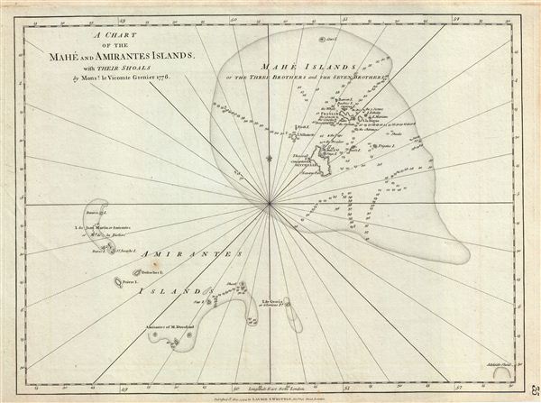
A Chart of the Mahe and Amirantes Islands with their Shoals.
1794 (dated) 18 x 23.5 in (45.72 x 59.69 cm) 1 : 900000
1794 (dated) 18 x 23.5 in (45.72 x 59.69 cm) 1 : 900000
Description
This is a fine example of Laurie and Whittle's 1794 nautical chart or maritime map of Mahe and Amirantes Islands, Seychelles. It covers the Mahe and Amirantes islands, also known as the Three Brothers and the Seven Brothers, along with their shoals. When this map was drawn, the Mahe and Amirantes islands, along with the rest of modern day Seychelles, were under French control. Following the French Revolution of 1790, the colonists formed an Assembly in an attempt to govern the islands autonomously. Jean Baptiste Quéau de Quinc became the leader of the colony in 1794, the same year this map was created. When armed British warships arrived, later in 1794, he negotiated favorable terms of capitulation and the Seychelles became a prosperous neutral colony. When nearby Mauritius finally surrendered in 1810, at the end of the Napoleonic Wars, the British took full control of the entire region.
The map offers rich detail including countless depth soundings, notes on the sea floor, commentary on reefs, rhumb lines, shoals, place names and a wealth of other practical information for the mariner. As noted in the title, Laurie and Whittle derived this map from an earlier survey completed the Frenchman Monsieur le Vicomte Grenier made in 1776. This map was published by Laurie and Whittle from their offices at 53 Fleet Street, London, on May 12, 1794.
The map offers rich detail including countless depth soundings, notes on the sea floor, commentary on reefs, rhumb lines, shoals, place names and a wealth of other practical information for the mariner. As noted in the title, Laurie and Whittle derived this map from an earlier survey completed the Frenchman Monsieur le Vicomte Grenier made in 1776. This map was published by Laurie and Whittle from their offices at 53 Fleet Street, London, on May 12, 1794.
Cartographer
Laurie and Whittle (fl. 1794 - 1858) were London, England, based map and atlas publishers active in the late 18th and early 19th century. Generally considered to be the successors to the Robert Sayer firm, Laurie and Whittle was founded by Robert Laurie (c. 1755 - 1836) and James Whittle (1757-1818). Robert Laurie was a skilled mezzotint engraver and is known to have worked with Robert Sayer on numerous projects. James Whittle was a well-known London socialite and print seller whose Fleet Street shop was a popular haunt for intellectual luminaries. The partnership began taking over the general management of Sayer's firm around 1787; however, they did not alter the Sayer imprint until after Sayer's death in 1794. Apparently Laurie did most of the work in managing the firm and hence his name appeared first in the "Laurie and Whittle" imprint. Together Laurie and Whittle published numerous maps and atlases, often bringing in other important cartographers of the day, including Kitchin, Faden, Jefferys and others to update and modify their existing Sayer plates. Robert Laurie retired in 1812, leaving the day to day management of the firm to his son, Richard Holmes Laurie (1777 - 1858). Under R. H. Laurie and James Whittle, the firm renamed itself "Whittle and Laurie". Whittle himself died six years later in 1818, and thereafter the firm continued under the imprint of "R. H. Laurie". After R. H. Laurie's death the publishing house and its printing stock came under control of Alexander George Findlay, who had long been associated with Laurie and Whittle. Since, Laurie and Whittle has passed through numerous permeations, with part of the firm still extant as an English publisher of maritime or nautical charts, 'Imray, Laurie, Norie and Wilson Ltd.' The firm remains the oldest surviving chart publisher in Europe. More by this mapmaker...
Source
Laurie, R., and Whittle, J., The East-India Pilot, or Oriental Navigator, on One Hundred and Eighteen Plates: Containing a Complete Collection of Charts and Plans, &c., &c. for the Navigation not only of the Indian and China Seas, but of those also between England and the Cape of Good-Hope; Improved and Chiefly Composed from the Last Work of M. D'Apres de Mannevillette; with Considerable Additions, from Private Manuscripts of the Dutch, and from Draughts and Actual Surveys Communicated By Officers of the East-India Company A New Edition, Containing One Hundred and Five Charts. (London: Laurie and Whittle) 1797.
Condition
Very good. Original platemark visible.