1961 Eddy Pictorial Strip Map, San Francisco to Chicago
SFChicago-eddy-1961$450.00

Title
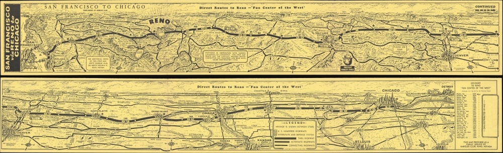
San Francisco via Reno to Chicago / Direct Routes to Reno - 'Fun Center of the West'.
1961 (dated) 4 x 27 in (10.16 x 68.58 cm)
1961 (dated) 4 x 27 in (10.16 x 68.58 cm)
Description
A whimsical two-sided pictorial strip map of highway routes between San Francisco and Chicago drawn by Gerald Eddy in 1961 for Harold's Club casino in Reno. Among other features, it is notable for showcasing Interstate 80, only designated five years prior. It is part of series of similar strip map issued by Eddy for Herod's Club, but by far the rarest.
Aside from cities and Harold's Club, other attractions and geographic features are illustrated throughout, including several national parks, major rivers, mountains, and the site of the 1960 Winter Olympics at Squaw Valley near Lake Tahoe.
A Closer Look
Beginning in San Francisco and ending in Chicago, this view follows Interstate 80 through Sacramento, Reno, Salt Lake City, Cheyenne, Omaha, and Des Moines to Chicago. As the home of Harold's Club, the main sponsor and distributor of the map, Reno is highlighted, with distances to the casino noted throughout and a table of distances between Reno and other major cities appearing at the end of the strip map on the verso. The verso also included a legend denoting types of highways. Having only been designated five years earlier, Interstate 80 in part ran concurrently with other highways which it mostly superseded, especially US 40.Aside from cities and Harold's Club, other attractions and geographic features are illustrated throughout, including several national parks, major rivers, mountains, and the site of the 1960 Winter Olympics at Squaw Valley near Lake Tahoe.
Harolds Club
Opened in 1935, Harolds Club, not to be confused with another Reno casino Harrah's (which bought the former casino and closed it in 1995), was among the earliest and most successful casinos in Reno and in Nevada writ large. The brothers Harold and 'Pappy' Smith were clever marketers, using bright electronic signage and a massive mural over the casino's entrance to drawn in patrons, while also using print media like the present strip map to reach a broad audience far beyond the city limits of Reno.Publication History and Census
This view was drawn by Gerald Eddy in 1961, one of several he did for Harold's Club in the late 1950s and early 1960s. The only example of this map in institutional collections is dated to 1959, perhaps an earlier edition, that is held by the Newberry Library.Cartographer
Gerald Allen Eddy (October 12, 1889 - September 9, 1967) was an American artist. Born in Michigan, Eddy's parents either divorced or his father died between 1900 and 1910. In 1910 Eddy was living with his mother, brother, and stepfather in Los Angeles and working as an artist. Eddy was a prolific cartographer and created numerous maps of different areas of the western United States. He was married and had a daughter by 1917, according to his World War I draft card. He was married to his wife Madolyn when he died. More by this mapmaker...
Condition
Very good. Light wear on original folds. Map continues on verso.
References
OCLC 1017474793 (dated 1959).