
1937 Conseil Municipal Diazotype Map of the Shanghai French Concession

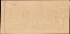
Plan de la Concession française Changhai.
Shanghai's French Concession amidst War.
$2,000.00
Choose a Collection:
- Digital Map Information
- Suitable for large format printing
- Full resolution TIFF file
- ICC color profile embedded
- Delivered instantly via download link
This Item
Enquire
Shanghai's French Concession amidst War.
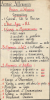
This is a large-format diazotype proof map of the Shanghai French Concession, produced by the Concession's administration in 1937, a period defined by the Battle of Shanghai (August 13 - November 26, 1937) and a refugee crisis. The verso is equally intriguing, though perhaps unrelated, and bears the handwritten Order of Battle of a German infantry division in French.A Closer Look
This map covers nearly the entirety of the Shanghai French Concession, from the Rue Haig (now Huashan Road) near Xujiahui (Zikawei) to the area near the Bund waterfront of the Huangpu River. Unfortunately, the easternmost edge of the map, encompassing the French Bund, is missing, possibly trimmed off. Streets and alleyways are depicted and labeled throughout, including Avenue Foch (now Yan'an Road) at the top, the dividing line between the French Concession and the International Settlement (historically British-dominated with a strong presence of Americans, but increasingly Japanese in this period). The Zikawei Creek appears at the bottom, marking the southern limit of the concession. The 'Chinese City' at bottom-right was the historic walled city of Shanghai which predated its designation as a treaty port; by this point, the city walls had been demolished but the area retained (and still largely does) the feel of a cramped, dense urban space, unlike the relatively spacious tree-lined boulevards of the French Concession, with their characteristic hybrid-style shikumen (石库门) apartments.Verso Content
The verso includes a list of the units of a German infantry division, written in very clear, ornate handwriting. It appears unlikely that this could have been a German unit in China, as Germany's concessions were dissolved after World War I (1914 - 1918). Even then, the largest German concession, at Jiaozhou (Qingdao), consisted of a single marine battalion. Instead, it appears that this diazo map of the French Concession made its way back to Paris (likely to the Quai d'Orsay / Ministre des Affaires étrangères), and its blank verso was repurposed due to paper shortages. The composition of the German units suggests a date contemporary with the Shanghai map on the recto, that is, late in the Interwar Period or early in World War II (with the units being a combination of older-style cavalry and 'minenwerfer' - World War I-era trench mortars - with more modern aspects, such as automobiles, anti-tank units, and howitzers). Curiously, the map bears no visible marks of having been hung up, such as tape residue or pinholes, making a complete understanding of how this artifact came to be in this state even more of a mystery.Shanghai French Concession - 上海法租界
On April 6, 1849, Lin Kouei (麟桂, c. 1804 - ?), the daotai (道臺, circuit attendant) of Shanghai, granted French Consul Charles de Montigny (1805 - 1868) a proclamation ceding extraterritoriality to France to establish a trading colony. The Concession initially occupied a narrow strip of land around the northern end of the Chinese City, south of the British settlement, and covered an area of 66 hectares. It was subsequently expanded several times. A further small strip of riverside land to the east of the Chinese City was added in 1861, to allow for the Quai de France, docks servicing shipping between China and France. Between 1899 and 1900, the French Concession underwent further expansion, nearly doubling in size with the addition of new territory extending west of the original grant. It expanded again in 1914, reaching as far west as modern Huashan Lu (Avenue Haig).By the 1920s, the western part of the French Concession had become the most desirable residential area of Shanghai, popular both with foreign nationals and wealthy Chinese. The skeletal French administration, run out of the Ministre des Affaires étrangères, 'farmed out' many governmental tasks to Catholic missionaries (especially the Jesuits based in Xujiahui), other civic organizations, and, above all, the Shanghai Green Gang, an extremely powerful mafia that oversaw opium, gambling, and prostitution in Shanghai. The French had entered into a veritable pacte avec le diable with the Green Gang in order to manage the overwhelmingly Chinese population of the French Concession, including the handling of troublesome labor disputes, and found itself at the gang's mercy.
The Battle for Shanghai and its Aftermath
Starting with the Japanese invasion of Manchuria (the 'Mukden Incident') in September 1931, Chinese and Japanese troops fought on-again, off-again battles in northern China for several years. One of these many skirmishes took place on July 7, 1937, at the 'Marco Polo Bridge' (Lugouwiao), just to the southwest of Beijing. Chiang Kai-shek had been reluctant to throw his armies into a full-scale war against the better-trained and equipped Japanese forces, but after the December 1936 Xi'an Incident (when he was kidnapped by one of his own generals), he was forced to bow to public pressure and launch the long-expected war. Chiang decided to dedicate the bulk of his forces to a battle for Shanghai, China's wealthiest and most important city, which raged in the closing months of 1937. Chinese-administered parts of the city, particularly Zhabei and Wusong to the north and east of the International Settlement, saw extensive bombardment and house-to-house fighting.Even the foreign concessions were not spared, most notoriously in the 'Black Saturday' incident, when a Chinese aircraft attempting to bomb a Japanese battleship on the Huangpu River released its payload early, right into the most heavily-populated part of the International Settlement, killing some 3,000 civilians, including many foreigners. Japanese planes also bombed targets in the foreign concessions (not always by accident), increasing already high tensions with the British, French, and Americans. Nevertheless, as the foreign concessions offered relative safety, they were inundated with tens of thousands of refugees who needed food and basic shelter. Eventually, a French Jesuit named Jacquinot de Besange (1878 - 1946) negotiated with the Japanese to establish a safety zone for civilians in the old Chinese city seen here that saved thousands of lives and became a model for other cities in China.
Despite the valiant efforts of Chinese troops, Japanese forces had naval, air, and artillery superiority and were able to receive sufficient resupply and reinforcements. The Japanese held their ground against Chinese attacks until a counter-attack was prepared, similar to the Soviet victory at Stalingrad six years later. Severely weakened by the fighting in Shanghai and with many units in disarray, Chiang arranged a hasty defense of Nanjing while planning for a retreat to Wuhan and then Chongqing, deep in the Chinese interior, to prepare for a long-term war of attrition.
As for Shanghai, the Chinese-administered parts of the city fell under a collaborationist administration that was incorporated into a national puppet regime based in Nanjing, following Japan's sanguinary capture of the Chinese capital. The foreign concessions were occupied by Japanese forces in conjunction with the attack on Pearl Harbor in December 1941 and abolished in 1943. The turnover was officially ratified after the war by the Sino-French Accord of February 1946, signed by the French Ambassador and Chiang Kai-Shek (who grudgingly assented to France's reoccupation of Indochina in exchange).
Publication History and Census
This map was prepared in 1937. It almost certainly was prepared by the Conseil Municipal of the French Concession, which would also be consistent with the verso content being a French official source. However, this map bears significant resemblance to a 1927 map printed by the Jesuits' Imprimerie de T'ou-Sè-Wè (see our earlier listing ShanghaiFrenchConcession-tousewe-1920). Given the very close relationship between the Jesuits and the French administration of the concession, it is conceivable that this diazo proof of a later (1937) edition of the Jesuits' map was sent to the Conseil Municipal, and then made its way back to France and was repurposed for the order of battle on the verso. In any event, we have been unable to locate any examples of the printed edition of this map, and have only been able to locate one example of a similar 1937 census map of the French Concession, cataloged on the website Virtual Shanghai.Condition
Average. Toning, some stains, minor edge wear.
References
Virtual Shanghai Document ID 2178.