This item has been sold, but you can get on the Waitlist to be notified if another example becomes available, or purchase a digital scan.
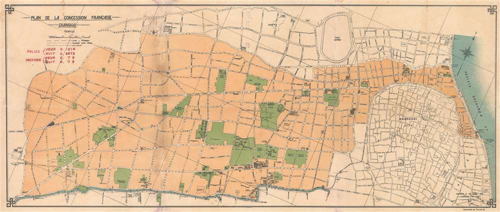
1920 T'ou-sè-wè Map of the French Concession, Shanghai, China
ShanghaiFrenchConcession-tousewe-1920
Title
1920 (undated) 12 x 28 in (30.48 x 71.12 cm) 1 : 8750
Description
Shanghai French Concession - 上海法租界
On April 6, 1849, Lin Kouei (麟桂), the Chinese governor of Shanghai, granted French Consul Charles de Montigny (1805 - 1868) a proclamation ceding extraterritoriality to France in order to establish a trading colony. The Concession initially occupied a narrow collar of land around the northern end of the Chinese City, south of the British settlement, an area of 66 hectares. It was subsequently expended several times. A further small strip of riverside land to the east of the Chinese City was added in 1861, to allow for the Quai de France, docks servicing shipping between China and France. Between 1899 and 1900 the French Concession further expanded, nearly doubling in size with new territory extending west of the original grant. It expanded again in 1914, reaching as far west as modern Huashan Lu (Avneue Haig). By the 1920s, the western part of the French Concession had become the most desirable residential area of Shanghai, popular both with foreign nationals and wealthy Chinese. The concession was mistakenly bombed during the chaotic 1937 Battle of Shangahi, fought between the National Revolutionary Army (NRA) of the Republic of China (ROC) and the Imperial Japanese Army (IJA). In 1943, the French Concession was handed over to the Japanese puppet Wang Jingwei Regime by Vichy France. The turnover was officially ratified after the war by the Sino-French Accord of February 1946, signed by the French Ambassador and Chiang Kai-shek. Today the French Concession, with its tree lined boulevards and French colonial architecture, remains Shanghai's most desirable neighborhood.Shanghai 1910 - 1932
The 1910s-20s were a golden age for Shanghai. While China was ruled by Chiang Kai-shek, Shanghai was dominated by several consolidated foreign trade Concessions. Under the strict administrative control of the Concessions, the city became a cosmopolitan haven in the midst of political unrest and a center for global trade and finance. The Concessions occupied what is today central Shanghai's most desirable land, hugging the Huangpu River and Wusong River (Suzhou Creek). These extraterritorial European, Japanese, and American enclaves had elegant housing, fine roads, streetcars, elegant shops, clubs, and more. It was a place of excess, art, and extravagance, where fortunes could be made by the enterprising - and lost by the foolish. Moreover, lacking the moral constrains that limited social life in Europe and America, Shanghai became nexus for the opium trade, sexual excess, gambling, and other vices. This ephemeral world come crashing down on January 28, 1932, when the Shanghai Incident or January 28 Incident pitted the Republic of China against the Empire of Japan. Responding to Chinese student protests against the Japanese occupation of Manchuria, the Japanese Navy bombarded Shanghai. Chiang Kai-shek sent the Chinese army in to defend the Shanghai students, threatening to escalate the conflict. The League of Nations, fearing all-out war, united to demand a ceasefire, which was signed. Nonetheless, most consider The January 28 incident to be the opening salvo of the Second Sino-Japanese War (1938 - 1945) which ultimately merged into World War IIPublication History and Census
This map was published by one of the most remarkable institutions in the history of Shanghai, the Chinese Jesuit funded T'ou-sè-wè Orphanage and Mission Press - one of the first modern printing houses in Shanghai. Although the map is undated, we can roughly date it by the unconstructed streets. Route Camille Lorioz, constructed in 1921, is here in the planning stage, limited this map production date to from 1919 - 1920. The present map is the only known example.Cartographer
T'ou-sè-wè (fl. c. 1900 - 1939) or 土山湾 or Tushanwan was a Chinese orphanage, vocational school, printing house active in the Xujiahui District of Shanghai, China. It is considered to be the birthplace of modern Chinese creative arts. T'ou-Sè-Wè, as it was then pronounced was initially a Jesuit Orphanage located just southwest of the old French Concession. The Orphanage was founded in 1864 and specialized in teaching their orphan charges practical vocations such as carpentry, stained-glass work, painting, wood carving, and printing. As a Catholic mission, the work of the orphanage often went into newly build churches, church projects, and other church properties. The publishing work of the T'ou-sè-wè printing house included numerous works both in French and Chinese on history, geography, theology the natural sciences, language, and astronomy. Their works received accolade at world exhibitions in 1900, 1915, 1935 and 1939. The Jesuits were expelled from Shanghai in 1949 by Communist revolutionaries, but the orphanage did fully not close until 1960. Today the site of the former orphanage houses the Tushanwan Museum, opened in June of 2010. More by this mapmaker...

