This item has been sold, but you can get on the Waitlist to be notified if another example becomes available, or purchase a digital scan.
1755 Bellin / Schley map of Siam, Vietnam and the Malay Peninsula
Siam-bellin-1755$295.00

Title
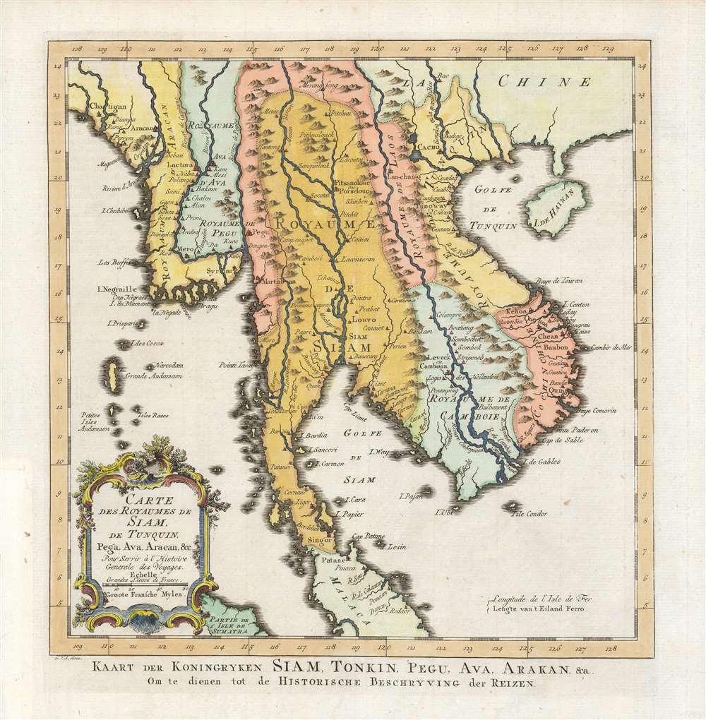
Carte des Royaumes de Siam, de Tunquin, Pegu, Ava, Aracan etc./ Kaart der Koningryken Siam, Tonkin, Pegu, Ava, Arakan etc./ Om te dienen tot de Historische Beschryving der Reizen.
1755 (undated) 11.5 x 10.75 in (29.21 x 27.305 cm) 1 : 14000000
1755 (undated) 11.5 x 10.75 in (29.21 x 27.305 cm) 1 : 14000000
Description
This is the 1755 Dutch edition of Bellin's map of Southeast Asia, engraved by Jakob van der Schley for inclusion in the Dutch edition of Abbe Prévost's Histoire Générale des Voyages. Centered on the Chao Phraya River, this map covers from the Kingdom of Aracan to the Gulf of Tonkin and from China to the Malay Peninsula, including the modern day nations of Thailand, Cambodia, Laos, Vietnam, Burma, and Malaysia. This map represented a considerable advancement of mapping of the interior of Southeast Asia over the maps of De l'Isle which preceded it, with numerous cities, fortifications, temples, and mountain ranges noted. The map identifies the cities of Siam (Ayutthaya), Bangkok, Lau Chang (Luong Prabong), and Pegu. Many of the islands in the Gulf of Thailand, including Samui, and in the Andaman Islands are noted as well.
Publication History and Census
The map was drawn by Jacques Nicolas Bellin to be published in volume 9 of the 1752 edition of Abbe Prévost's Histoire Générale des Voyages. For the Dutch edition published by Pieter Hondt in The Hague in 1755, the maps were re-engraved by Jakob van der Schley. A further edition of this map was printed for the 1773 Atlas portatif, pour servir à l'intelligence de l'histoire philosophique et politique des etablissements et du commerce des Européens dans les deux Indes. The 1755 edition can be distinguished from the 1773 by the composition of the final sentence of the Dutch title: the last four words of the 1755 read 'Historische Beschryving der Reizen' whereas the 1773 read 'Historische Beschryving der Volkpl.' Separate examples of the 1755 are catalogued in the Universiteit Leiden and the Bayerische Staatsbibliothek. The Histoire Générale is well represented in institutional collections.CartographerS
Jacques-Nicolas Bellin (1703 - March 21, 1772) was one of the most important cartographers of the 18th century. With a career spanning some 50 years, Bellin is best understood as geographe de cabinet and transitional mapmaker spanning the gap between 18th and early-19th century cartographic styles. His long career as Hydrographer and Ingénieur Hydrographe at the French Dépôt des cartes et plans de la Marine resulted in hundreds of high quality nautical charts of practically everywhere in the world. A true child of the Enlightenment Era, Bellin's work focuses on function and accuracy tending in the process to be less decorative than the earlier 17th and 18th century cartographic work. Unlike many of his contemporaries, Bellin was always careful to cite his references and his scholarly corpus consists of over 1400 articles on geography prepared for Diderot's Encyclopedie. Bellin, despite his extraordinary success, may not have enjoyed his work, which is described as "long, unpleasant, and hard." In addition to numerous maps and charts published during his lifetime, many of Bellin's maps were updated (or not) and published posthumously. He was succeeded as Ingénieur Hydrographe by his student, also a prolific and influential cartographer, Rigobert Bonne. More by this mapmaker...
Jacob Van der Schley (1715 - 1779) was a prominent Amsterdam engraver and draftsman based out of Amsterdam. Schley apprenticed under portrait engraver Bernard Picart, whose style he imitated. He is said to have completed several of Picart's portraits following his master's death. While Schley is primarily known for his work as a portraitist and illustrator, he also has a considerable cartographic corpus. He is known to have worked with Bellin, Hondt, and Provost, among others. Learn More...
Antoine François Prévost d'Exiles (April 1, 1697 – November 25, 1763), usually known the Abbé Prévost, was a French author and novelist. Having had difficulty in his youth determining a preference for life in the military or life among the Jesuits, he eventually wound up with the Benedictines, with whom he took vows. Despite his taking the vows, the vows evidently did not take with him: in 1728 he abandoned his abbey and fled to London. Naturally, he became a writer. In this he was prolific, both producing his own work and translations of others. Beginning in 1726, he published the first volume of his Histoire générale des voyages, which he worked on for the remained of his life and which was completed by his associates after his death, stretching to 25 volumes. Learn More...
Source
Prévost, A., Histoire Générale des Voyages, ou Nouvelle Collection de Toutes les Relations de Voyages par Mer et par Terre..., (Amsterdam: Pierre de Hondt ) 1746 - 1759.
Prévost's Histoire Générale des Voyages is a 15-volume compendium of travel literature initiated by Antoine François Prévost (Provost; 1697 - 1763) in 1746, intended as a universal history of exploration and geography. The initial publication, compiled from 1746 to 1759, spans 15 volumes and draws from a vast array of sources - travelers, explorers, missionaries, merchants, and diplomats - to present detailed narratives of significant global journeys. The work was initially published in Paris by Didot and offers ethnographic, political, religious, and natural observations about the peoples, cultures, flora, fauna, and geography. It is an ambitious attempt to organize knowledge about the world's diversity according to Enlightenment values, reflecting both scientific curiosity and imperial ideology. It functioned as both an informative reference and a literary work, influencing how European audiences understood and imagined distant lands. It proved extremely successful, and both reissues other publishers and pirate editions emerged, most notably Pierre de Hondt's 1747 Dutch edition and Jean-Franćois de la Harpe's 1780 abridged version. In addition to reissues of the original work, between 1768 and 1801, additional expanded volumes emerged, adding new voyages and histories. We have seen some sets with as many as 80 volumes. Over time, the Histoire générale des voyages became one of the most comprehensive and widely read travel collections of the 18th century, notable for blending factual reporting with the period's characteristic intellectual ambition.
Condition
Very good. Margin reinstated at insertion point, not impacting printed image.
References
OCLC 164345934.