1742 Coronelli Nolin Map of Southeast Asia (Siam, Thailand, Malaya, Laos, Vietnam)
Siam-coronellinolin-1742$10,000.00

Title
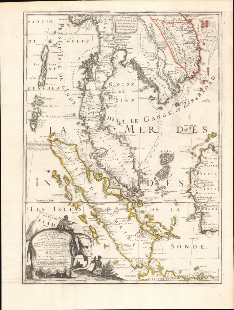
Royaume De Siam, avec Les Royaumes qui luy sont-Tributaries, et les Isles de Sumatra, Andemaon, etc.
1742 (dated) 19 x 25 in (48.26 x 63.5 cm) 1 : 4430000
1742 (dated) 19 x 25 in (48.26 x 63.5 cm) 1 : 4430000
Description
This is the important and influential Coronelli-Nolin map of Southeast Asia, considered one of the Holy Grails of Siam-related map collecting. Here in its 1742 edition, the map was first issued in 1687, following the 1685 first French embassy to Siam, led by Alexandre, Chevalier de Chaumont (1640 - 1710). Most Europeans were expelled from Siam a year later in 1688, making this the definitive model of all subsequent maps of Siam, and Southeast Asia in general until the 1821 John Crawfurd Embassy.
When Chaumont and his 6 Jesuit companions arrived in the Siamese capital, it was during an unprecedented golden age known as the Ayutthaya Period (1351 - 1767). During this period, Siam expanded dramatically, annexing U Thong, Lopburi, and former Khmer strongholds including Angkor. It was also a period of social and philosophical growth, leading to modernized legal systems and a flowering of the arts. Ayutthaya (Judtija) itself, the capital, boasted a population in excess of 1,000,000 and was likely the largest city in the world.
The Siamese monarch at the time of the embassy, King Narai the Great (Ramathibodi III; 1632 - 1688), was fascinated with foreigners, especially the French. He had foreign advisors and even allowed for the construction of a French fort south of the capital at a bend in the Chao Phraya that is today Bangkok. Although Narai retained his Buddhist faith, his son and heir was converted to Christianity.
In 1688, two years after the Chaumont Embassy, and perhaps because of it and the ramifications it suggested, one of Narai's chief advisors, Phetracha (1632 - 1703), led an anti-foreigner revolution. Phetracha ordered the killing Narai's Christian heir and possibly Narai (although he was already ill) and established himself as King. Phetracha reversed Narai's pro-French policies, expelling all missionaries, and laying siege to the fort at Bangkok. Under Phetracha and his heirs, only the Dutch were allowed a limited presence, essentially closing Siam to foreign influence for the subsequent 150 years.
The new cartographic information gathered by Chaumont transmitted was passed on, via the agency of the semi-official Royal cartographer Jean-Baptiste Nolin, to the Venetian, Vincenzo Maria Coronelli, considered the finest cartographer in Europe. Coronelli, who made two magnificent and colossal globes for the French King Louis XIV, was much admired in court and granted special access to these and other records. Via Coronelli and Nolin, the limited reconnaissance of the Chaumont embassy presented here, became the definitive European reference for Siam and Southeast Asia until the early 19th century.
A Closer Look
Coverage embraces from Martaban (modern day Myanmar / Burma) and Kehoa (Quang Binh Province, Vietnam) to Java and the Strait of Sunda (Sonde), thus including all southern Siam (Thailand), Laos, Cambodia, southern Vietnam, Malaya, Singapore, Sumatra, the Andaman and Nicobar Islands, and western Borneo. The track of the 1885-86 Chaumont Embassy is illustrated, entering the South China Sea via the Straits of Sunda, coasting eastern Malaya through the Gulf of Siam to the mouth of the Chao Phraya River, and returning south via the coast of Cambodia, to again pass through the Sunda Strait. In the lower left, the title cartouche evocatively takes the form of a white elephant, an age-old symbol the Siamese monarchy.Historical Context
Although first contacted by a Portuguese Embassy in 1511, Siam remained little known to Europeans. The Dutch and French were allowed a few trading and resupply posts along the Chao Phraya River south of modern-day Bangkok but failed to penetrate inland. Nor did Siam have an indigenous cartographic tradition that could be assimilated or copied, so these early points of contact generated few maps. This began to change with the 1685-86 Chevalier de Chaumont Embassy.When Chaumont and his 6 Jesuit companions arrived in the Siamese capital, it was during an unprecedented golden age known as the Ayutthaya Period (1351 - 1767). During this period, Siam expanded dramatically, annexing U Thong, Lopburi, and former Khmer strongholds including Angkor. It was also a period of social and philosophical growth, leading to modernized legal systems and a flowering of the arts. Ayutthaya (Judtija) itself, the capital, boasted a population in excess of 1,000,000 and was likely the largest city in the world.
The Siamese monarch at the time of the embassy, King Narai the Great (Ramathibodi III; 1632 - 1688), was fascinated with foreigners, especially the French. He had foreign advisors and even allowed for the construction of a French fort south of the capital at a bend in the Chao Phraya that is today Bangkok. Although Narai retained his Buddhist faith, his son and heir was converted to Christianity.
In 1688, two years after the Chaumont Embassy, and perhaps because of it and the ramifications it suggested, one of Narai's chief advisors, Phetracha (1632 - 1703), led an anti-foreigner revolution. Phetracha ordered the killing Narai's Christian heir and possibly Narai (although he was already ill) and established himself as King. Phetracha reversed Narai's pro-French policies, expelling all missionaries, and laying siege to the fort at Bangkok. Under Phetracha and his heirs, only the Dutch were allowed a limited presence, essentially closing Siam to foreign influence for the subsequent 150 years.
The new cartographic information gathered by Chaumont transmitted was passed on, via the agency of the semi-official Royal cartographer Jean-Baptiste Nolin, to the Venetian, Vincenzo Maria Coronelli, considered the finest cartographer in Europe. Coronelli, who made two magnificent and colossal globes for the French King Louis XIV, was much admired in court and granted special access to these and other records. Via Coronelli and Nolin, the limited reconnaissance of the Chaumont embassy presented here, became the definitive European reference for Siam and Southeast Asia until the early 19th century.
Publication History and Census
This map was first published in 1687 by Jean-Baptiste Nolin and Vincenzo Maria Coronelli. The present example is the 1742 second edition, issued from the same plates by Jean-Baptiste Nolin's son, also Jean-Baptiste Nolin. Although well represented in select European institutions, on the private market, all editions and examples are extremely scarce and highly desirable.CartographerS
Vincenzo Maria Coronelli (August 16, 1650 - December 9, 1718) was an important 17th-century cartographer and globe maker based in Venice. Coronelli was born the fifth child of a Venetian tailor. Unlikely to inherit his father's business, he instead apprenticed in Ravenna to a woodcut artist. Around 1663, Coronelli joined the Franciscan Order and, in 1671, entered the Venetian convent of Saint Maria Gloriosa dei Frari. Coronelli excelled in the fields of cosmography, mathematics, and geography. Although his works include the phenomenal Atlante Veneto and Corso Geografico, Coronelli is best known for his globes. In 1678, Coronelli was commissioned to make his first major globes by Ranuccio II Farnese, Duke of Parma. Each superbly engraved globe was five feet in diameter. Louis IV of France, having heard of the magnificent Parma globes, invited Coronelli to Paris, where from 1681-83 he constructed an even more impressive pair of globes measuring over 12 feet in diameter and weighing 2 tons each. The globes earned him the patronage of Louis XIV and privileged access to French cartographic information from Jesuit sources in the New World, particularly Louisiana. Coronelli returned to Venice and continued to publish globes, maps, and atlases, which were admired all over Europe for their beauty, accuracy, and detail. He had a particular fascination for the Great Lakes region, and his early maps of this area were unsurpassed in accuracy for nearly 100 years after their initial publication. He is also well known for his groundbreaking publication of the first accurate map depicting the sources of the Blue Nile. At the height of his career, Coronelli founded the world's first geographical society, the Accademia Cosmografica degli Argonauti, and was awarded the official title Cosmographer of the Republic of Venice. In 1699, in recognition of his extraordinary accomplishment and scholarship, Coronelli was also appointed Father General of the Franciscan Order. The great cartographer and globe maker died in Venice at the age of 68. His extraordinary globes can be seen today at the Bibliothèque Nationale François Mitterrand in Paris, Biblioteca Marciana in Venice, the National Library of Austria, the Globe Museum in Vienna, the Library of Stift Melk, the Special Collections Library of Texas Tech University, as well as lesser works in Trier, Prague, London, and Washington D.C. Coronelli's work is notable for its distinctive style, which is characterized by the high-quality white paper, dark intense impressions, detailed renderings of topographical features in profile, and numerous cartographic innovations. More by this mapmaker...
Jean-Baptiste Nolin (1657 - 1725) was a French cartographer and publisher active in Paris during the late 17th and early 18th centuries. Nolin was a man of exceptional business acumen and while many cartographers struggled financially, he prospered. Many attribute this to the fact that Nolin produced very little original work, relying primarily on business relationships with the legendary Italian cartography Vincenzo Coronelli, Jean-Dominique Cassini, and the French geographer Jean Nicolas du Trallage, Sieur de Tillemont (1620 – 1698). His work is known for exceptional aesthetic élan, combining Italianesque baroque and rococo ethics with most current cartographic data. It might also be said that Nolin was a bit of a con-artist in his self-promotion, often inaccurately using such titles as 'Engraver to the King' and 'Geographer to the Duke of Orleans', neither of which appointments he actually held. In 1705, he was successfully sued by Guillaume De L’Isle for copyright infringement, a case which cost him significant scientific credibility. Nonetheless, Nolin remained commercially popular and prosperous. Nolin's son, also Jean Baptiste Nolin (1686 - 1762) inherited his father’s map plates and republished many of his maps, as well as issuing his own unique maps, well into the 18th century. Both Nolins maintained offices on Rue St. Jacques, Paris. Learn More...
Condition
Very good. A few minor verso reinforcements along old fold lines.
References
OCLC 15670260.