1742 Nolin Map of the Bay of Bengal, Siam (Thailand), and India
SiamBengalIndia-nolin-1742$1,200.00

Title
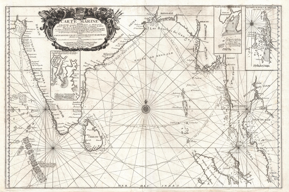
Carte Marine depuis Suratte jusqu'au Detroit de Malaca Dressee par le R.P. Tachard de la Compagnie de Jesus Missionaire et Mathematicien du Roy dans les Indes.
1742 (dated) 19.5 x 29 in (49.53 x 73.66 cm) 1 : 5100000
1742 (dated) 19.5 x 29 in (49.53 x 73.66 cm) 1 : 5100000
Description
An impressive separately-issued 1742 nautical map of the Bay of Bengal, India, and Southeast Asia (Thailand, Cambodia) by J. B. Nolin. The map chronicles the travels of the Jesuit Priest Guy Tachard in his attempts to establish a Siamese-French alliance, the eventual collapse of that alliance, and anti-French Siamese Revolution of 1688.
Tachard's second voyage commenced a year later in 1667. It was organized by Jean-Baptiste Colbert and led by Marshal Desfarges, Simon de la Loubère, and Claude Céberet du Boullay, director of the French East India Company. This voyage brought the Siamese ambassador home and cemented a trade alliance between France and Narai's Siam.
Unfortunately, the military nature of the fleet, including 5 warships and French troops who established a fortified base at what would become Bangkok, engendered anti-French sentiment. A nationalist anti-foreign movement led by the official Phra Petratcha ultimately resulted in the 1688 Siamese Revolution, in which King Narai was overthrown and killed. Petratcha assumed the throne and immediately drove the French out of Siam.
Tachard, meanwhile, returned to France accompanied by a Siamese representative, Ok-khun Chamnan Chaichong, 'Ambassador Extraordinary for the King of Siam'. Unaware of the overthrow of Narai, Tachard and Ok-khun toured Europe and were introduced with fanfare to Pope Innocent XI.
In 1690, Tachard attempted to return to Siam a third time, but Phra Petratcha denied him entry. A fourth attempt followed in 1699, but likewise did little to improve Siamese-French relations.
A Closer Look
Coverage embraces from Surat to the Maldives to the Gulf of Siam (Gulf of Thailand). It extends south along the Strait of Malacca into Malay as far as Malacca. Inset maps provide additional detail of the vicinity of Goa, the vicinity of Mergui (Myeik, Myanmar/Burma), and the port of Negrailles.The Voyages of Guy Tachard
The map follows the voyages of Guy Tachard (1651 - 1712), a Jesuit missionary who twice visited Siam (Thailand). The first voyage, commencing in 1685, was led by Chevalier de Chaumont and François-Timoléon de Choisy. It was officially a scientific expedition to India and China, but was more likely focused on military and trade reconnaissance. Tachard hoped to foster an alliance between Louis XIV of France and the pro-foreign King of Siam, Narai (Ramathibodi III). When the embassy returned to France in 1686, an ambassador of the Siamese court, Kosa Pan, was on board with a proposal.Tachard's second voyage commenced a year later in 1667. It was organized by Jean-Baptiste Colbert and led by Marshal Desfarges, Simon de la Loubère, and Claude Céberet du Boullay, director of the French East India Company. This voyage brought the Siamese ambassador home and cemented a trade alliance between France and Narai's Siam.
Unfortunately, the military nature of the fleet, including 5 warships and French troops who established a fortified base at what would become Bangkok, engendered anti-French sentiment. A nationalist anti-foreign movement led by the official Phra Petratcha ultimately resulted in the 1688 Siamese Revolution, in which King Narai was overthrown and killed. Petratcha assumed the throne and immediately drove the French out of Siam.
Tachard, meanwhile, returned to France accompanied by a Siamese representative, Ok-khun Chamnan Chaichong, 'Ambassador Extraordinary for the King of Siam'. Unaware of the overthrow of Narai, Tachard and Ok-khun toured Europe and were introduced with fanfare to Pope Innocent XI.
In 1690, Tachard attempted to return to Siam a third time, but Phra Petratcha denied him entry. A fourth attempt followed in 1699, but likewise did little to improve Siamese-French relations.
Publication History and Census
This map was first issued in 1701. The present edition has been revised and updated to 1742. We note 6 examples of the 1742 edition cataloged in OCLC: Harvard University, the Biblothèque Nationale de France, the Universiteit van Amsterdam, and three university collections in Germany.Cartographer
Jean-Baptiste Nolin (1657 - 1725) was a French cartographer and publisher active in Paris during the late 17th and early 18th centuries. Nolin was a man of exceptional business acumen and while many cartographers struggled financially, he prospered. Many attribute this to the fact that Nolin produced very little original work, relying primarily on business relationships with the legendary Italian cartography Vincenzo Coronelli, Jean-Dominique Cassini, and the French geographer Jean Nicolas du Trallage, Sieur de Tillemont (1620 – 1698). His work is known for exceptional aesthetic élan, combining Italianesque baroque and rococo ethics with most current cartographic data. It might also be said that Nolin was a bit of a con-artist in his self-promotion, often inaccurately using such titles as 'Engraver to the King' and 'Geographer to the Duke of Orleans', neither of which appointments he actually held. In 1705, he was successfully sued by Guillaume De L’Isle for copyright infringement, a case which cost him significant scientific credibility. Nonetheless, Nolin remained commercially popular and prosperous. Nolin's son, also Jean Baptiste Nolin (1686 - 1762) inherited his father’s map plates and republished many of his maps, as well as issuing his own unique maps, well into the 18th century. Both Nolins maintained offices on Rue St. Jacques, Paris. More by this mapmaker...
Condition
Good. Map is bright and clean. From the right margin and about 1 inch into the map has been expertly restored.
References
Hollis 012632199. OCLC 248608216.