This item has been sold, but you can get on the Waitlist to be notified if another example becomes available, or purchase a digital scan.
1689 Coronelli Map of Ayutthaya, Siam (Thailand)
SiamIudia-coronelli-1689-2$1,750.00

Title
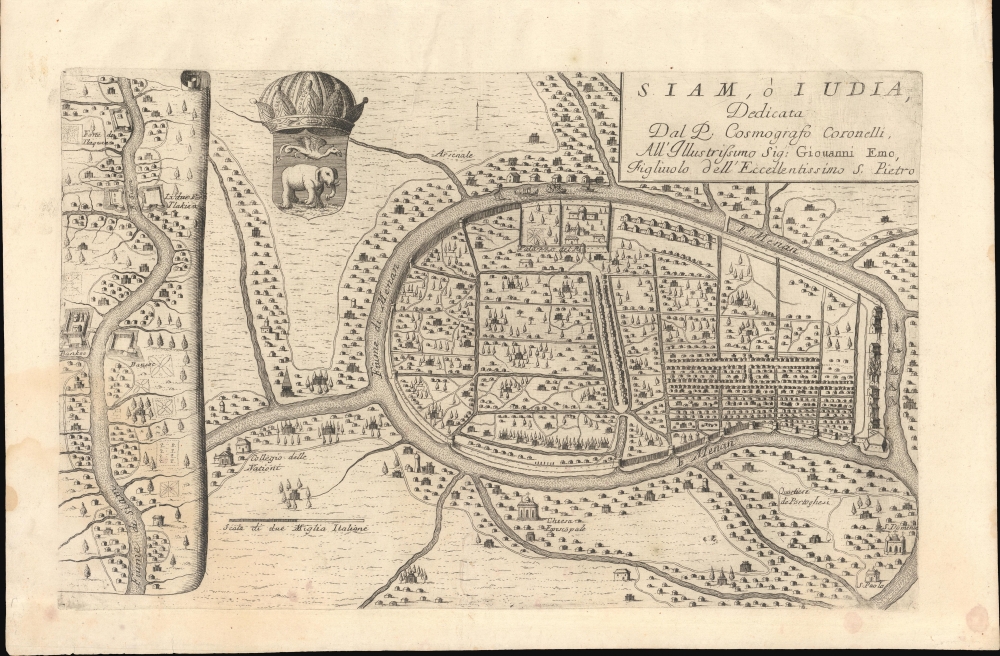
Siam, ò Iudia, Dedicata Dal P. Cosmografo Coronelli All'Illustrissimo Sig: Giouanni Emo.
1689 (undated) 10.5 x 17 in (26.67 x 43.18 cm) 1 : 36500
1689 (undated) 10.5 x 17 in (26.67 x 43.18 cm) 1 : 36500
Description
This is Coronelli's important 1689 map of Ayutthaya, representing the Siamese capital at the height of the Ayutthaya Period (1351 - 1767), considered a golden age for Thailand. At the time, Ayutthaya was the world's largest, most sophisticated city, with a population exceeding 1,000,000. The cartography here immediately predates the 1688 Siamese Revolution, and thus includes foreign settlements, churches, and schools. All of these were violently expelled in the Revolution's aftermath. As such, this map reflects the most sophisticated European mapping of the Siamese capital through the 18th century - the Siamese themselves did not make maps as such.
The larger, at right, illustrates the city Ayutthaya, situated on an island formed by a dramatic curve in the Menan (Chao Phraya) River. It features an elaborate canal system, strong fortifications, and a dense inner city. To the southeast is the 'Quartiere de Portoghesi' (Portuguese Quarter), a well-established trade colony complete with three catholic churches. Further west, in the unlabeled 'French' district, we see the Collegio delle Nationi, according to Fr. João Alvares, a French boys' school established c. 1660.
A secondary map at left follows the Chao Phraya south past several fortified positions, most notably Bangkok (Bankoc). Although unlabeled as such, the mapping likely represents French interest in the Chao Phraya and Bangkok, where, from 1687, they maintained a troop presence. Moreover, it reflects the French military strategy of Bangkok as 'key to the kingdom', from which traffic along the Chao Phraya could be fully controlled.
The map also features a dramatic rendering of the Siamese royal crest, featuring an elephant and a Garuda.
Phaulkon's rise to power was unpopular with the Siamese nobility. Phra Phetracha (1632 - 1703), a member of Narai's extended family, led an anti-foreign opposition party. As a traditionalist, Phetracha opposed Narai's open-door policy and was vexed by missionary efforts to convert the throne to Catholicism, the garrisoning of French troops in Bangkok, and Phaulkon's growing influence.
When Narai was on his deathbed in May of 1688, Phetracha launched a coup, the Siamese Revolution of 1688, which placed him on the throne and established the Ban Phlu Luang Dynasty. As King, he was fast to act, expelling foreigners from Ayutthaya while arresting, torturing, and killing Phaulkon. He then led an army of some 40,000 men to Bangkok, which he besieged, eventually forcing the French to abandon Siam entirely. Afterward, he closed Siam to most foreign influence, with only the Dutch permitted tightly controlled trading rights.
Ayutthaya remained the capital of Siam until 1767, when it was sacked at the end of the Burmese-Siamese War (1765 - 1767), ending the Ayutthaya Period and the Siamese Golden Age. The capital was subsequently moved south to the more easily defensible Bangkok.
A Closer Look
This map is divided into two sections:The larger, at right, illustrates the city Ayutthaya, situated on an island formed by a dramatic curve in the Menan (Chao Phraya) River. It features an elaborate canal system, strong fortifications, and a dense inner city. To the southeast is the 'Quartiere de Portoghesi' (Portuguese Quarter), a well-established trade colony complete with three catholic churches. Further west, in the unlabeled 'French' district, we see the Collegio delle Nationi, according to Fr. João Alvares, a French boys' school established c. 1660.
A secondary map at left follows the Chao Phraya south past several fortified positions, most notably Bangkok (Bankoc). Although unlabeled as such, the mapping likely represents French interest in the Chao Phraya and Bangkok, where, from 1687, they maintained a troop presence. Moreover, it reflects the French military strategy of Bangkok as 'key to the kingdom', from which traffic along the Chao Phraya could be fully controlled.
The map also features a dramatic rendering of the Siamese royal crest, featuring an elephant and a Garuda.
The Siamese Revolution of 1688
The cartography is based upon reconnaissance collected during Alexandre Chevalier de Chaumont's 1685 visit. Chaumont was the ambassador of King Louis XIV of France to the court the Siamese king, Narai the Great (Ramathibodi III; 1632 - 1688). Narai was obsessed with everything European and welcomed foreign embassies, missionaries, and merchants. He even established Constantine Phaulkon (1648 - 1688), a Greek adventurer formerly with the British East India Company, as his Prime Councilor.Phaulkon's rise to power was unpopular with the Siamese nobility. Phra Phetracha (1632 - 1703), a member of Narai's extended family, led an anti-foreign opposition party. As a traditionalist, Phetracha opposed Narai's open-door policy and was vexed by missionary efforts to convert the throne to Catholicism, the garrisoning of French troops in Bangkok, and Phaulkon's growing influence.
When Narai was on his deathbed in May of 1688, Phetracha launched a coup, the Siamese Revolution of 1688, which placed him on the throne and established the Ban Phlu Luang Dynasty. As King, he was fast to act, expelling foreigners from Ayutthaya while arresting, torturing, and killing Phaulkon. He then led an army of some 40,000 men to Bangkok, which he besieged, eventually forcing the French to abandon Siam entirely. Afterward, he closed Siam to most foreign influence, with only the Dutch permitted tightly controlled trading rights.
Ayutthaya remained the capital of Siam until 1767, when it was sacked at the end of the Burmese-Siamese War (1765 - 1767), ending the Ayutthaya Period and the Siamese Golden Age. The capital was subsequently moved south to the more easily defensible Bangkok.
Publication History and Census
This map was engraved in 1688 or 1689 by Coronelli's workshops for inclusion in his Citta, Fortezze e, Isole, e Porti principlai dell'Europa in Pianta et in Elevatione, Descritte, e Publicate Ad uso dell'Accademia Cosmografica degli Argonauti dal Padre Maestro Coronelli Lettore, e Cosmografo della Serenissima Republica di Venezia, one of Coronelli's most significant and important works. Rare. We see no separate examples in the OCLC.Cartographer
Vincenzo Maria Coronelli (August 16, 1650 - December 9, 1718) was an important 17th-century cartographer and globe maker based in Venice. Coronelli was born the fifth child of a Venetian tailor. Unlikely to inherit his father's business, he instead apprenticed in Ravenna to a woodcut artist. Around 1663, Coronelli joined the Franciscan Order and, in 1671, entered the Venetian convent of Saint Maria Gloriosa dei Frari. Coronelli excelled in the fields of cosmography, mathematics, and geography. Although his works include the phenomenal Atlante Veneto and Corso Geografico, Coronelli is best known for his globes. In 1678, Coronelli was commissioned to make his first major globes by Ranuccio II Farnese, Duke of Parma. Each superbly engraved globe was five feet in diameter. Louis IV of France, having heard of the magnificent Parma globes, invited Coronelli to Paris, where from 1681-83 he constructed an even more impressive pair of globes measuring over 12 feet in diameter and weighing 2 tons each. The globes earned him the patronage of Louis XIV and privileged access to French cartographic information from Jesuit sources in the New World, particularly Louisiana. Coronelli returned to Venice and continued to publish globes, maps, and atlases, which were admired all over Europe for their beauty, accuracy, and detail. He had a particular fascination for the Great Lakes region, and his early maps of this area were unsurpassed in accuracy for nearly 100 years after their initial publication. He is also well known for his groundbreaking publication of the first accurate map depicting the sources of the Blue Nile. At the height of his career, Coronelli founded the world's first geographical society, the Accademia Cosmografica degli Argonauti, and was awarded the official title Cosmographer of the Republic of Venice. In 1699, in recognition of his extraordinary accomplishment and scholarship, Coronelli was also appointed Father General of the Franciscan Order. The great cartographer and globe maker died in Venice at the age of 68. His extraordinary globes can be seen today at the Bibliothèque Nationale François Mitterrand in Paris, Biblioteca Marciana in Venice, the National Library of Austria, the Globe Museum in Vienna, the Library of Stift Melk, the Special Collections Library of Texas Tech University, as well as lesser works in Trier, Prague, London, and Washington D.C. Coronelli's work is notable for its distinctive style, which is characterized by the high-quality white paper, dark intense impressions, detailed renderings of topographical features in profile, and numerous cartographic innovations. More by this mapmaker...
Source
Coronelli, V., Citta, Fortezze, Isole, e Porti Principali dell'Europa, (Venice: Domenico Padovani) 1689.
Condition
Very good.