1772 Vaugondy / Diderot Map of Asia, Alaska, and the Northeast Passage
SiberiaAlaska-vaugondy-1772-2$350.00
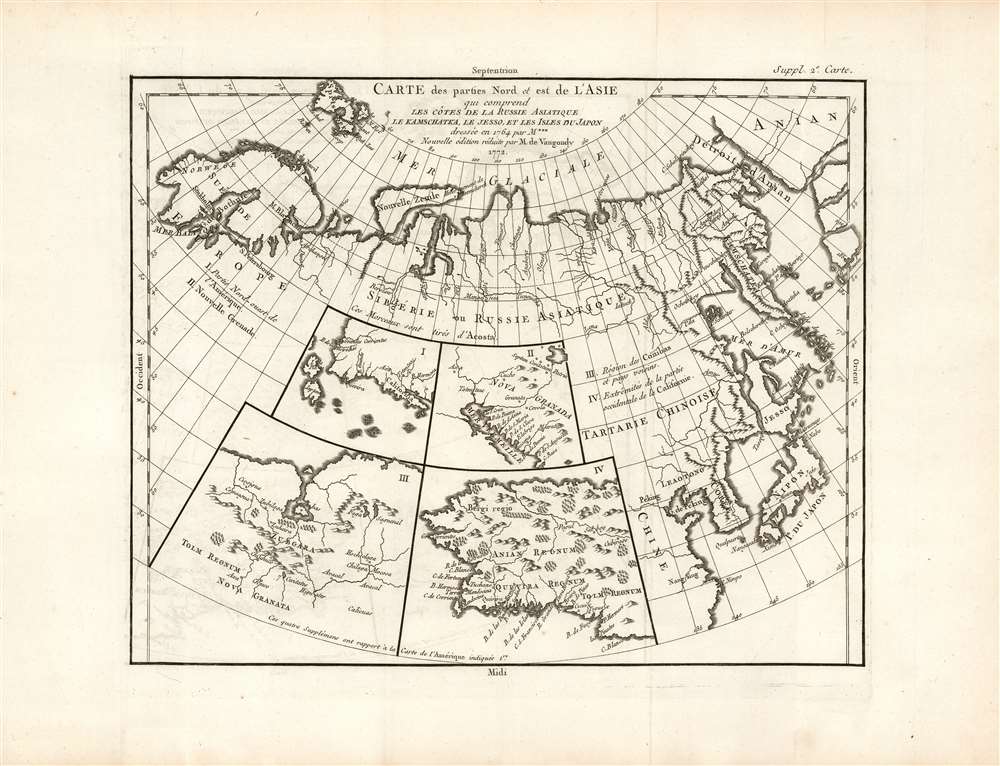

Title
Carte des Parties Nord et Est de l'Asie qui Comprend les Cotes de la Russie Asiatique le Kamschatka, le Iesso, et les Isles du Japon.
1772 (undated) 12.25 x 15 in (31.115 x 38.1 cm)
1772 (undated) 12.25 x 15 in (31.115 x 38.1 cm)
Description
A map of the Northeast Passage, the northeast coasts of Asia, and the American Northwest. The Northeast Passage, much like America's Northwest Passage, was a long sought after sea route through the Arctic that would save European merchantman the expense of rounding Africa in order to access the trade riches of East Asia. This map deals primarily with Asiatic Russia, detailing the Northeast Passage from Norway and Iceland westward as far as Alaska (Anian), Kamchatka, Hokkaido (Yesso), and Japan. Knowledge of this area was, at the time, speculative at best and this is reflected here in the depictions of many unknown islands, misshapen representations of Kamchatka, Japan, Hokkaido (Yesso), and Alaska. Notes Peking (Beijing), Nanking (Nanjing), Corea (Korea), Jedo (Tokyo), and Nangasaki (Nagasaki).
Inset Maps
The four inset maps of America depicted in the lower left are of special interest. All four loosely reference Wytfliet's seminal 1597 atlas. The upper left inset (I), depicts the northwest coast of America from the Bay of California to a conjectural Alaska, a misshapen Japan, and a mysterious 'I. de Plata' (Island of Silver). Depicts the mythical city of Quivira on the Alaskan coast. This map was based upon the California sheet of Wytfliet's atlas. Inset (II), also drawn from the Wytfliet California, shows the Bay of California and Nova Granada. Plate (III) depicts the Conibas-Zubgara region. This region, which appeared first in Mercator's 1569 atlas, has been loosely interpreted, as either as the Northwest Passage, the Hudson Bay, or the first map of the Great Lakes. Plate IV shows what is almost certainly Alaska, labeled Anian Regnum.Anian
Here is a real cartographic curiosity, where myth becomes fact, which again becomes myth. Anian is a term used in John Donne poem, 'Anyan if I go west by the North-West passage.' In was interpreted as a kid of Bering Strait by some early cartographers, successfully transitioning it from the realms of poetry to cartography. Anian presupposed the existence of a Northwest Passage and, as such, was entirely mythical, despite any resemblance to modern-day Alaska.Publication History and Census
This map is part of the 10 map series prepared by Vaugondy for the Supplement to Diderot's Encyclopédie, of which this is plate 2. This seminal map series, exploring the mapping of North American and specifically the Northwest Passage was one of the first studies in comparative cartography. The Supplément à l'Encyclopédie is well represented in institutional collections. We see six examples of the separate map catalogued in OCLC.CartographerS
Robert de Vaugondy (fl. c. 1716 - 1786) was French may publishing from run by brothers Gilles (1688 - 1766) and Didier (c. 1723 - 1786) Robert de Vaugondy. They were map publishers, engravers, and cartographers active in Paris during the mid-18th century. The father and son team were the inheritors to the important Nicolas Sanson (1600 - 1667) cartographic firm whose stock supplied much of their initial material. Graduating from Sanson's maps, Gilles, and more particularly Didier, began to produce their own substantial corpus. The Vaugondys were well-respected for the detail and accuracy of their maps, for which they capitalized on the resources of 18th-century Paris to compile the most accurate and fantasy-free maps possible. The Vaugondys compiled each map based on their own geographic knowledge, scholarly research, journals of contemporary explorers and missionaries, and direct astronomical observation. Moreover, unlike many cartographers of this period, they took pains to reference their sources. Nevertheless, even in 18th-century Paris, geographical knowledge was limited - especially regarding those unexplored portions of the world, including the poles, the Pacific Northwest of America, and the interiors of Africa, Australia, and South America. In these areas, the Vaugondys, like their rivals De L'Isle and Buache, must be considered speculative or positivist geographers. Speculative geography was a genre of mapmaking that evolved in Europe, particularly Paris, in the middle to late 18th century. Cartographers in this genre would fill in unknown lands with theories based on their knowledge of cartography, personal geographical theories, and often dubious primary source material gathered by explorers. This approach, which attempted to use the known to validate the unknown, naturally engendered rivalries. Vaugondy's feuds with other cartographers, most specifically Phillipe Buache, resulted in numerous conflicting papers presented before the Academie des Sciences, of which both were members. The era of speculative cartography effectively ended with the late 18th-century explorations of Captain Cook, Jean Francois de Galaup de La Perouse, and George Vancouver. After Didier died, his maps were acquired by Jean-Baptiste Fortin, who in 1787 sold them to Charles-François Delamarche (1740 - 1817). While Delamarche prospered from the Vaugondy maps, he defrauded Vaugondy's window Marie Louise Rosalie Dangy of her rightful inheritance and may even have killed her. More by this mapmaker...
Denis Diderot (October 5, 1713 - July 31, 1784) was a French Enlightenment era philosopher, publisher and writer. Diderot was born in the city of Langres, France and educated at the Lycée Louis le Grand where, in 1732, he earned a master of arts degree in philosophy. Diderot briefly considered careers in the clergy and in law, but in the end chose the more fiscally challenge course of a writer. Though well respected in philosophical circles Diderot was unable to obtain any of the government commissions that commonly supported his set and consequently spent much of his life in deep poverty. He is best known for his role in editing and producing the Encyclopédie . The Encyclopédie was one of the most revolutionary and impressive works of its time. Initially commissioned as a translation of Ephraim Chambers' Cyclopaedia, or Universal Dictionary of Arts and Sciences, Diderot instead turned into a much larger and entirely new work of monumental depth and scope. Diderot's Encyclopédie was intended to lay bare before the common man the intellectual mysteries of science, art and philosophy. This revolutionary mission was strongly opposed by the powers of the time who considered a learned middle class it a threat to their authority. In the course of the Encyclopédie production Diderot was imprisoned twice and the work itself was officially banned. Nonetheless, publication continued in response to a demand exceeding 4000 subscribers. The Encyclopédie was finally published in 1772 in 27 volumes. Following the publication of the Encyclopédie Diderot grew in fame but not in wealth. When the time came to dower his only surviving daughter, Angelique, Diderot could find no recourse save to sell his treasured library. In a move of largess, Catherine the II Russia sent an emissary to purchased the entire library on the condition that Diderot retain it in his possession and act as her "librarian" until she required it. When Diderot died of gastro-intestinal problems 1784, his heirs promptly sent his vast library to Catherine II who had it deposited at the Russian National Library, where it resides to this day. Learn More...
Source
Supplement to Diderot, D., Encyclopédie, ou dictionnaire raisonné des sciences, des arts et des métiers; or Robert de Vaugondy, G., Recueil de 10 Cartes Traitant Particulierement de L'Amerique du Nord, (Paris) 1779.
Condition
Excellent. Original platemark visible, with generous margins. An unusually sharp, bold strike. Some faint offsetting, else fine.
References
Rumsey 10402.000. OCLC: 945089117. Wagner 637. Wheat 160. Tooley 100. Pedley, Mary Sponberg, Bel et Utile: The Work of the Robert de Vaugondy Family of Mapmakers, #406.