This item has been sold, but you can get on the Waitlist to be notified if another example becomes available, or purchase a digital scan.
1850 / 1821 Horsburgh Nautical Chart / Map of Singapore Strait
Singapore-horsburgh-1850$2,500.00

Title
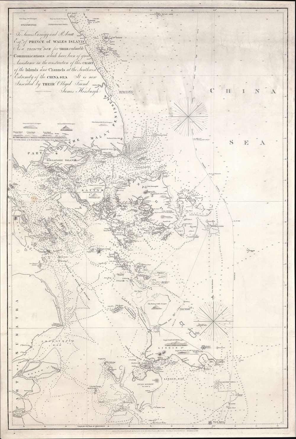
To James Carnegy and R. Scott Esqrs. of Prince of Wales Island As a Tribute due for their valuable Communications which have been of great Assistance in the construction of this chart of the Islands and Channels at the Southwest Extremity of the China Sea. It is not Inscribed by their Obliged Friend James Horsburgh.
1850 (dated) 39.5 x 26.25 in (100.33 x 66.675 cm) 1 : 390000
1850 (dated) 39.5 x 26.25 in (100.33 x 66.675 cm) 1 : 390000
Description
The rare 1850 final edition of the James Horsburgh nautical map of Singapore and the surrounding waters when it was the epicenter of British power in the East Indies. The chart covers the southern extreme of the Malay Peninsula, including all of Singapore Island and Singapore Strait, as well as adjacent islands and parts of eastern Sumatra. It was Horsburgh's first chart of the dangerous waters surrounding the Strait of Singapore and was the definitive mapping of these seas for nearly 30 years.
Historical Context
When this map was issued, Singapore was the capital of the Straits Settlements and, as now, the hub of trade between the Indian Ocean (and thus Europe) and China. At the time of publication, in 1850, there were roughly 60,000 residents. Near Singapore city, 'Govern. Ho.', the British colonial headquarters from which the Straits Settlements were administered is noted. Malay Town' is located to south, as is the New Harbour (Keppel Harbour), the main deep water port.The Dedication
The chart is titled in the form of an elaborate dedication to James Carnegy (1770 - 1824) and Robert Scott (1789 - 1846), both commanders in the 'Malay Trade,' based in Penang, or as it was then known, Prince of Wales Island. When this chart was initially published, the island's main city, George Town, founded in 1786, was the principal British trading center in the region and the capital of the Straits Settlements until 1846, when it was eclipsed by Singapore.Publication History and Census
This chart was first issued by James Horsburgh for the British Admiralty in 1821 - although we are aware of no surviving examples of that edition. Subsequent editions followed, with Horsburgh's own updates, in 1824 and 1831. After Horsburgh's death in 1836, the plates were regularly updated by the British Admiralty in 1841, 1849, and (as here) 1850. The present example, 1850, represents the 6th and final state.CartographerS
James Horsburgh (September 28, 1762 – May 14, 1836) was a Scottish hydrographer and navigator active in the late 18th and early 19th century. Horsburgh was born in Fife, Elie, Scotland, to a humble family. Like many young Scottish men of little means, Horsburgh was destined for a sea-faring life and at just 16 signed on as a cabin boy in a coal trading ship. After many misadventures, including a brief incarceration by the French at Dunkirk, Horsburgh made his way to the West Indies and eventually to Calcutta, India. As the center for British maritime trade in the region, Horsburgh had no difficulty finding work with the British East India Company who maintained an active trade network between India and China. Despite the regular trade, one these voyages to China, aboard the ironically named Atlas, taught Horsburgh just how poorly the East Indies were charted. The 1786 shipwreck of the Atlas, on which he was the First Mate, near Diego Garcia Island proved a pivotal moment Horsburgh's life. He subsequently devoted himself to accurately charting the Indian Ocean and the dangerous Straits of Malacca, Sunda, and Singapore. Many of Horsburgh's charts are the direct results of his own unique survey work on board the Carron and later as captain of the Anna. Horsburgh's work culminated in the publication if his 1809 Directions for Sailing to and from the East Indies, China, New Holland, Cape of Good Hope, and the Interjacent Ports, a monumentally important guide to navigating the waters of the Indian Ocean and the East Indies. His work earned him friendships in London's highest naval and scientific circles, among them Joseph Banks and Alexander Dalrymple. He became a member of the Royal Society in 1806, when he retired from active sailing. When Alexander Dalrymple died in 1810, Horsburgh was appointed to the prestigious position of Hydrographer to the British East India Company where he worked until his death in 1836. Whereas Dalrymple was somewhat indiscriminate regarding the charts he published, Horsburgh was exacting and double checked the veracity of each and every chart that passed through his office. Horsburgh's work with the East India Company elevated the standards of the Hydrographic Department and earned him a Fellowship with the Royal Society. Today's Horsburgh's accomplishments are memorialized by the Horsburgh Lighthouse, near Singapore, and Horsburgh Island. When Horsburgh died most of his work was passed by his children to the Admiralty, which continued to publish updates until roughly 1864. More by this mapmaker...
John Bateman (fl. 1804 – 1825) was a British copperplate printer, map, and chart engraver active in London during the early part of the 19th century. Bateman is best known for his maps and charts, especially of the East Indies engraved for James Horsburgh and published between 1804 and 1825. He appears to have spent time in the East Indies with records documenting him in Calcutta as early in 1799 and may have befriended Horsburgh there. Some have speculated that John Bateman is related to Richard Bateman, another map and chart engraver active during roughly the same period. Learn More...
The British Admiralty Office (1795 - Present) or the United Kingdom Hydrographic Office refers to the Branch of the English government that is responsible for the command of the British Navy. In 1795 King George III created the United Kingdom Hydrographic Office, known in short as the U.K.H.O., to provide top notch nautical charts to the vast Royal Navy. Prior the founding of the Admiralty the surveying and creation of nautical charts was primarily a commercial venture wherein the cartographer himself, more of than not, actually financed the printing of his own material. The great navigator Cook himself is known to have scrambled for funds to publish his own seminal charts - the most important and advanced of the period. The system of privately funded nautical mapping and publishing left vast portions of the world uncharted and many excellent charts unpublished. King George III, responding significant loss in trade revenue related to shipwrecks and delay due to poor charts, recognized the need for an institutionalized government sponsored cartographic agency - the Admiralty. The first head of the Admiralty, a position known as Hydrographer, was the important cartographer Alexander Dalrymple. Dalrymple started by organizing and cataloging obtainable charts before initiating the laborious process of updating them and filling in the blanks. The first official Admiralty Chart appeared in 1800 and detailed Quiberon Bay in Brittany. By 1808 the position of Hydrographer fell to Captain Thomas Hurd. Hurd advocated the sale of Admiralty charts to the general public and, by the time he retired in 1829, had issued and published some 736 charts. Stewardship of the organization then passed to Rear Admiral Sir Francis Beaufort. It was under Beaufort's administration that the Admiralty truly developed as a "chart making" as opposed to a "chart cataloging" institution. Beaufort held his post from 1829 to 1854. In his 25 years at the Admiralty Beaufort created nearly 1500 new charts and sponsored countless surveying and scientific expeditions - including the 1831 to 1836 voyage of the H.M.S. Beagle. By 1855 the Admiralty's chart catalog listed some 1,981 charts. Learn More...
Condition
Good. A view tears repaired and reinforced on verso. Paper watermarked 'Whatman 1853'.
References
OCLC 967235075. Boston Public Library, G8073.R5P5 1850 .H67. cf. 1849 edition, National Library of Singapore (Lee Kong Chian Reference Library), 623.8922472 HOR.