This item has been sold, but you can get on the Waitlist to be notified if another example becomes available, or purchase a digital scan.
1830 Murray / Raffles Map and Chart of Singapore
Singapore-murray-1830$1,100.00

Title
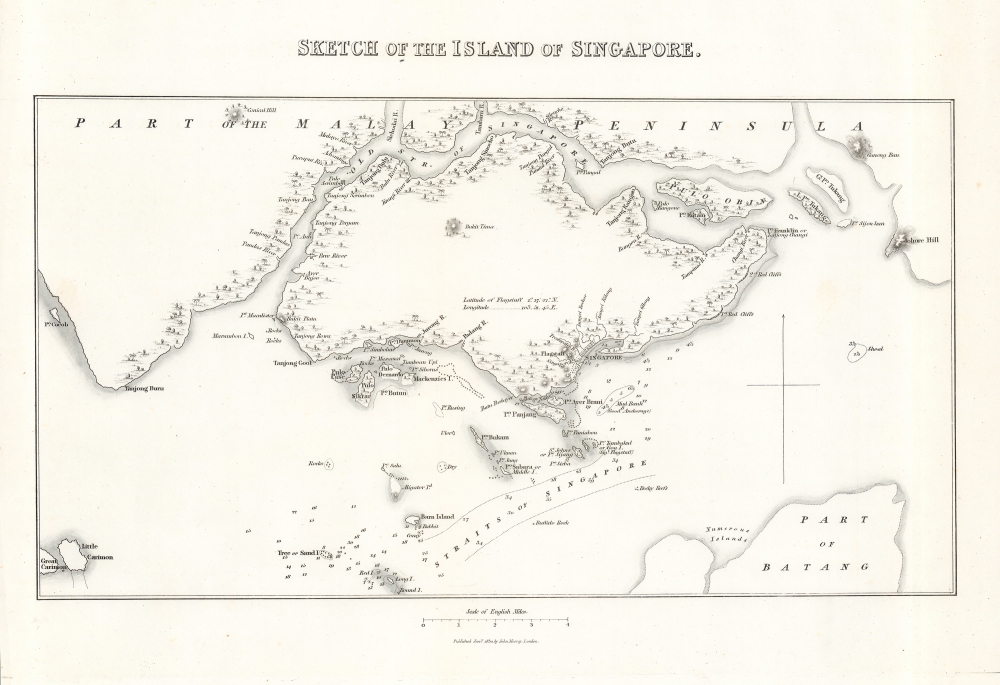
Sketch of the Island of Singapore.
1830 (dated) 9 x 12.75 in (22.86 x 32.385 cm) 1 : 129300
1830 (dated) 9 x 12.75 in (22.86 x 32.385 cm) 1 : 129300
Description
A scarce, early map and chart of Singapore, published by John Murray in 1830 for Lady Sophia Raffles' Memoir of the life and public services of Sir Thomas Stamford Raffles, four years after her husband's death. It depicts the nascent colonial city in the early years after the development of the Raffles Town Plan, a partially-realized scheme for the city's future development.
From the beginning, Singapore witnessed rapid growth and high volume as a port. With limited funds, Farquhar could not fully control the urban development of Singapore Town and allowed haphazard organic growth. When Raffles returned in October of 1822, he was displeased by the chaotic development and so commissioned Lieutenant Philip Jackson, who himself had just arrived in Singapore, to create a new development plan outlining his ambitious urban vision.
A Closer Look
The island of Singapore and its environs are displayed, with the burgeoning colonial city towards right. Noted prominently is the flagstaff on Government Hill, later incorporated into Fort Canning, used to signal the arrival of ships in the harbor. Small rivers and indigenous Malay settlements are noted along the island's coast. Mostly local names are recorded for the many hills (bukit), capes (tanjung, here as tanjong), and other features along the coast, including 'Point Franklin or Tanjong Changi,' now the site of the country's main airport. On the water, islands (Pulo or Palau) are noted in detail along with hazards, reefs, banks, and soundings.Historical Context
Stamford Raffles founded Singapore as a British colony in 1819, looking for a site to challenge the Dutch, who had a colony at Melaka from which they threatened to dominate the Straits of Malacca. Finding a sparsely populated but strategically located island at the end of the Malay Peninsula with a natural deep harbor and fresh water, Raffles intervened in a factional struggle in the Sultanate of Johor, which nominally controlled the island, supporting one faction in exchange for being granted the island. Having engineered the handover to British sovereignty, Raffles set it up as a free port and promptly returned to Bencoolen, leaving William Farquhar (1774 - 1839) to manage the colony.From the beginning, Singapore witnessed rapid growth and high volume as a port. With limited funds, Farquhar could not fully control the urban development of Singapore Town and allowed haphazard organic growth. When Raffles returned in October of 1822, he was displeased by the chaotic development and so commissioned Lieutenant Philip Jackson, who himself had just arrived in Singapore, to create a new development plan outlining his ambitious urban vision.
The Raffles Vision
Raffles' plan for Singapore called for structured, centrally planned development with racial and social segregation. The European area would be located to the east of the cantonment (the government area) and the area southwest of the Singapore River would be used for commerce. Raffles correctly predicted that the Chinese would eventually constitute the largest community, reserving a large area southwest of the Singapore River. Indians were to be settled further up the river, and the Bugis and Arabs were also allocated distinct areas. Raffles mistakenly believed that there would not be significant numbers of Malay settlers, but thought the upper banks of the river could be reserved for them. In addition to apportioning land, Raffles also determined a location for the Telok Ayer Market, stipulated that burial grounds be placed far from the town, and required urban uniformity in the layout of streets. Although not exactly considered a master plan for the development of Singapore, Raffles' Plan had a strong influence on the subsequent settlement and development of the colonial town.Publication History and Census
This map appeared in Lady Sopia Raffles' Memoir of the life and public services of Sir Thomas Stamford Raffles published by John Murray in London in 1830. The present map is only independently listed among the institutional holdings of the British Library and only occasionally appears on the market, while the entire book is somewhat more widely distributed in institutions but still quite rare.Cartographer
John Murray I (1737 - 1793) founded the British publishing firm John Murray (1768 - present) in London. Born in Edinburgh, Murray served as an officer in the Royal Marines and built a list of authors that included Isaac D’Israeli and published the English Review. Murray the elder also was one of the founding sponsors of the London evening newspaper The Star in 1788. John Murray II (November 27 1778 - June 27, 1843) continued the family publishing business and developed it into one of the most important and influential publishing houses in Britain. The list of authors published by the firm grew to include Jane Austen, Sir Walter Scott, Washington Irving, George Crabbe, and Lord Byron under his tenure. Murray II also moved the business to 50 Albermarle Street in Mayfair, which became famous for Murray’s tradition of ‘four o’clock friends’, which was afternoon tea with his writers. John Murray III (1808 - 1892) continued to grow the business, and the firm published the first English translation of Goethe’s Theory of Colours, David Livingstone’s Missionary Travels and Charles Darwin’s Origin of Species during his tenure. Murray also published Herman Melville’s first two books. The firm began publishing Murray Handbooks in 1836, an ancestor of all modern travel guides. Sir John Murray IV (1851 - 1928) was publisher to Queen Victoria. Three successive Murray’s after Murray IV led the business until it was purchased by Hodder Headline in 2002, which was acquired by the French conglomerate Lagardère Group in 2004. Today, Murray is an imprint of Lagardère under the imprint Hachette UK. More by this mapmaker...
Source
Raffles, Sophia, Memoir of the life and public services of Sir Thomas Stamford Raffles, F.R.S., (London: John Murray) 1830.
Condition
Good. Uneven toning along fold line at right. A couple areas of soiling. Offsetting present though faint.
References
OCLC 557483856.