This item has been sold, but you can get on the Waitlist to be notified if another example becomes available, or purchase a digital scan.
1938 F.M.S. City Map or Plan of Singapore
Singapore2-fmssurveys-1938$1,000.00

Title
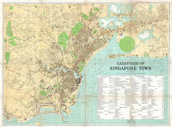
Gazetteer of Singapore Town.
1938 (dated) 29 x 39 in (73.66 x 99.06 cm) 1 : 9600
1938 (dated) 29 x 39 in (73.66 x 99.06 cm) 1 : 9600
Description
This is a 1938 F.M.S. Survey city map or plan of Singapore. The map depicts the city of Singapore from Bukit Timah Road and Telok Blanga Road to the Sea View Hotel and Paya Lebar. Highly detailed, individual buildings are illustrated throughout the city, several of which are labeled. The Lee Rubber Factory, several Muslim (Mohammedan per the map) cemeteries, and the Firestone Rubber Company are among the labeled locations. The Royal Singapore Flying Club sits near the Singapore Civil Airport, with a seaplane approach and anchorage running out into the channel. Neighborhoods are labeled, along with myriad roads and several parks. Trolley and bus routes are depicted using either a solid or dashed line, respectively. An index of cinemas, public offices, consulates, and other locations around the city is located in the lower right corner.
This map was produced by F.M.S. Surveys in 1938.
This map was produced by F.M.S. Surveys in 1938.
Cartographer
Federated Malay States Survey (1922 - 1945), better known as the F.M.S. Survey Department, was established in the early 20th century to produce detailed surveys of British Malaya and the Straits Settlements. The survey department had offices in most major Malayan ports, including Singapore, Kuala Lumpur, Penang (Georgetown), and Malacca. They were the first official survey organization to publish detailed scientifically produced maps of the region. More by this mapmaker...
Condition
Good. Some soiling. Verso repairs to fold separations. Map of Singapore and Jahore on verso.
References
OCLC 222051361.