This item has been sold, but you can get on the Waitlist to be notified if another example becomes available, or purchase a digital scan.
1945 British War Office Map of Southern Singapore
SingaporeMain-waroffice-1945$500.00

Title
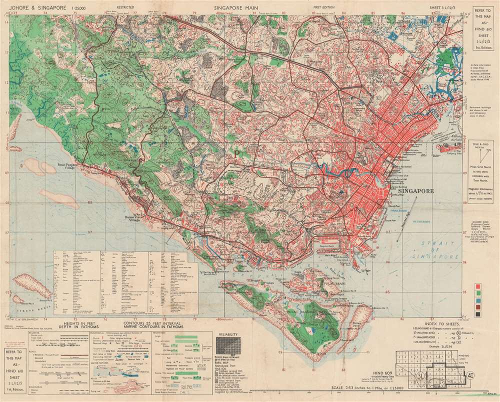
Singapore Main. HIND 610 Sheet 3 L/12/5. First Edition.
1945 (dated) 19.25 x 24 in (48.895 x 60.96 cm) 1 : 25000
1945 (dated) 19.25 x 24 in (48.895 x 60.96 cm) 1 : 25000
Description
This is a 1945 British War Office map of southern Singapore. The map depicts the region from the Pandan River to Kallang Airfield and from the Sleepy Valley Estate to Pulau Blakang Mati. Highly detailed, individual buildings are illustrated throughout the region, some of which are labeled, including stores, sports areas, hospitals, prisons, factories, government buildings, schools, and churches. Roads snake their way from one end of the area to the other, providing access to nearly every part of the island. An index of abbreviations used is situated in the lower left quadrant, just above a key explaining the various notations present.
Publication History and Census
This map was created and published by the Survey Production Centre for South East Asia of the Geographical Section of the General Staff of the War Office. It was revised by the Seventh Indian Air Survey Company and produced by the 66 Indian Reprographic Group in August 1945. We are aware of three examples in institutional collections which are part of the collections at Southern Illinois University, the Australian War Memorial, and the National Archives of Singapore. This map is extremely rare on the market as we have been able to trace only one other occurrence in recent years when it has been available.Cartographer
The British War Office (1857 - 1964) was a department of the British Government responsible for the administration of the Royal Army until 1964, when its functions were transferred to the Ministry of Defense. The War Office was to the Royal Army what the Admiralty was to the Royal Navy, and later, the Air Ministry. Within the War Office, the General Staff Topographical Section was responsible for thousands of maps issued for British intelligence and military use. The Topographical Section was renamed Geographical Section in April 1907. Many, once their military use passed, were offered through licensed agents to the general public. The sole London agent for War Office material was Edward Stanford. More by this mapmaker...
Condition
Very good. Light wear along original fold lines. Light soiling. Blank on verso.
References
OCLC 785809563.