This item has been sold, but you can get on the Waitlist to be notified if another example becomes available, or purchase a digital scan.
1870 Admiralty Chart of Singapore Strait
SingaporeStrait-admiralty-1870$2,000.00

Title
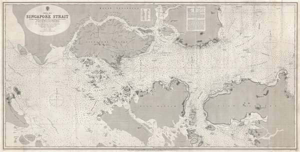
China Sea Singapore Strait.
1870 (dated) 26 x 51 in (66.04 x 129.54 cm) 1 : 100000
1870 (dated) 26 x 51 in (66.04 x 129.54 cm) 1 : 100000
Description
A rare 1870 British Admiralty nautical chart or maritime map of the Singapore Strait. Centered Singapore city and the narrow strait between Singapore Island and Pulo Battam (Pulau Batam) the map extends west as far as the Malacca Strait and east to South Channel and Pulo Bintang (Pulau Bintan), north to the mouth of the Johore River, and south to Pulo Rempang (Pulau Rempang). The map offers good detail of Singapore town noting individual buildings, in particular Fort Canning. There are countless depth soundings in fathoms throughout.
This chart was initially produced in 1868 and follows Staff Commander John William Reed's major resurvey of the Singapore Strait region, completed on the HMS Rifleman between 1865 and 1868. The present edition, 1870, represent the fourth state of the map. It was engraved by Davies, Bryer and Company. Admiralty Chart no 2403.
This chart was initially produced in 1868 and follows Staff Commander John William Reed's major resurvey of the Singapore Strait region, completed on the HMS Rifleman between 1865 and 1868. The present edition, 1870, represent the fourth state of the map. It was engraved by Davies, Bryer and Company. Admiralty Chart no 2403.
CartographerS
The British Admiralty Office (1795 - Present) or the United Kingdom Hydrographic Office refers to the Branch of the English government that is responsible for the command of the British Navy. In 1795 King George III created the United Kingdom Hydrographic Office, known in short as the U.K.H.O., to provide top notch nautical charts to the vast Royal Navy. Prior the founding of the Admiralty the surveying and creation of nautical charts was primarily a commercial venture wherein the cartographer himself, more of than not, actually financed the printing of his own material. The great navigator Cook himself is known to have scrambled for funds to publish his own seminal charts - the most important and advanced of the period. The system of privately funded nautical mapping and publishing left vast portions of the world uncharted and many excellent charts unpublished. King George III, responding significant loss in trade revenue related to shipwrecks and delay due to poor charts, recognized the need for an institutionalized government sponsored cartographic agency - the Admiralty. The first head of the Admiralty, a position known as Hydrographer, was the important cartographer Alexander Dalrymple. Dalrymple started by organizing and cataloging obtainable charts before initiating the laborious process of updating them and filling in the blanks. The first official Admiralty Chart appeared in 1800 and detailed Quiberon Bay in Brittany. By 1808 the position of Hydrographer fell to Captain Thomas Hurd. Hurd advocated the sale of Admiralty charts to the general public and, by the time he retired in 1829, had issued and published some 736 charts. Stewardship of the organization then passed to Rear Admiral Sir Francis Beaufort. It was under Beaufort's administration that the Admiralty truly developed as a "chart making" as opposed to a "chart cataloging" institution. Beaufort held his post from 1829 to 1854. In his 25 years at the Admiralty Beaufort created nearly 1500 new charts and sponsored countless surveying and scientific expeditions - including the 1831 to 1836 voyage of the H.M.S. Beagle. By 1855 the Admiralty's chart catalog listed some 1,981 charts. More by this mapmaker...
John William Reed (1826 – November 18, 1873) was a British naval officer active in the East Indies and the Pacific in the middle part of the 19th century. Reed was born in Sheerness, near Chatham, Kent, England. The son of a Royal Navy shipwright, john joined the navy as a clerk in 1840. Looking for a more active duty, he became an assistant to a Master of the Royal Navy, and was promoted to second master in July of 1851. In 1853 records place him in the South Pacific where, working on board the HMS Saracen, he was part of a team dispatched to survey the Fijian Coast, the later the coasts of Taiwan, Korea, Japan. By 1856 he had risen to become an Assistant Surveyor. The HMS Saracen was decommissioned in 1860 and Reed returned to England where he was reassigned to duties in the North Atlantic, including visits to Labrador and Greenland. He was given command of the HMS Rifleman in 1861 and once again dispatched to the East Indies. After two years of service in the East Indies, he returned again to England, possibly due to sickness or an injury. In 1866, the HMS Rifleman was again dispatched to the East Indies, again with Reed in command. He was assigned to complete a detailed survey of the waters between Singapore and Hong Kong, the first major update to this region since the work of John Turnbull Thomson. Reed completed his seminal survey, but by 1868 his health broke down again and he returned to England and retired. His ship, the HMS Rifleman, was similarly decommissioned. He died four years later in 1873, probably from tropical diseases contracted in his travels. Edward Reed, his brother, was an important British shipwright. Learn More...
Davies, Bryer, and Company (fl. 1866 – 1872) was an English, London based, map engraving firm active in the middle part of the 19th century. The partnership consisted of 'Davies' who may or may not be the prominent map engraver Benjamin Rees Davies (1789 - 1872) and Frederick Bryer (1840 – 1919). The firm was contracted by the British Admiralty Hydrographic Office to engrave several important nautical charts in the 1860s through the 1870s. The partnership appears to have dissolved around 1872 and, although both publishers continued to engrave charts independently, no later charts bear the Davies, Bryer and Company imprint. Learn More...
Condition
Very good.
References
Royal Maritime Museum, Greenwich, G257:4/6.