This item has been sold, but you can get on the Waitlist to be notified if another example becomes available, or purchase a digital scan.
1847 Kollner Map of the Battle of Canada during the Taos Uprising in New Mexico
SketchApril18-kollner-1847$150.00

Title
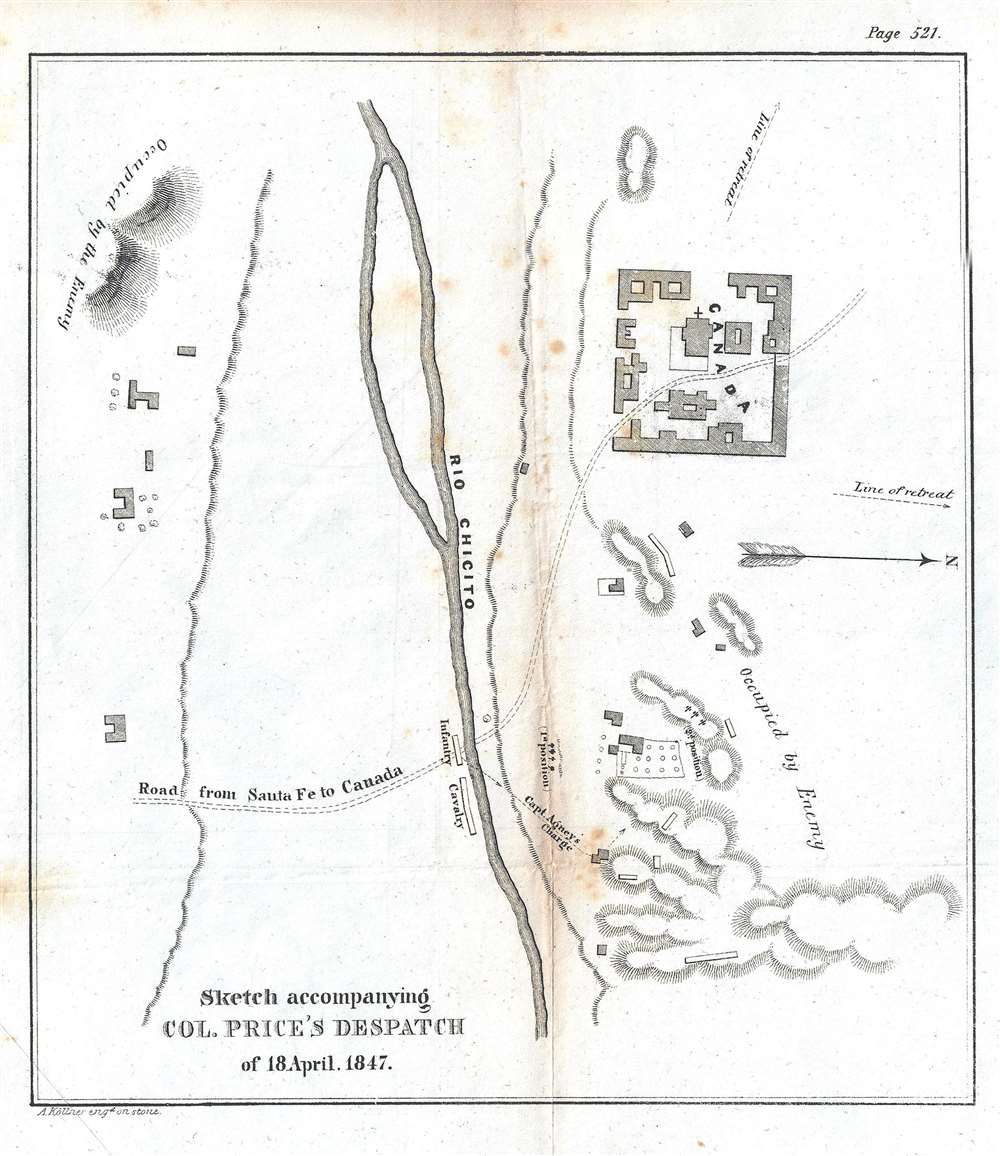
Sketch accompanying Col. Price's Despatch of 18 April 1847.
1847 (undated) 9 x 8 in (22.86 x 20.32 cm)
1847 (undated) 9 x 8 in (22.86 x 20.32 cm)
Description
This is an 1847 William Hemsley Emory map of the Battle of Cañada one of the battles during the Taos Revolt in and near Taos, New Mexico, which was part of the Mexican-American War. Oriented to the west, the map is bisected by the Rio Chicito, with the road from Santa Fe to Cañada illustrated by two dashed lines. Cañada itself is on the north side of the river and several buildings are noted, though none are labeled. Numerous buildings are illustrated throughout the countryside, along with the region's topography, allowing the viewer to have some understanding of the terrain where the battle occurred.
Thus, when violence ignited on the morning of January 19, 1847, plenty of animosity was felt by the insurrectionists and their supporters. The revolt began in Don Fernando de Taos (present-day Taos, New Mexico) and was led by Pablo Montoya, a Hispano, and Tomás Romero, a Taos Puebloan. A Native American force, led by Romero, broke into Governor Bent's house and shot him with arrows and scalped him in front of his family. Bent survived the attack, and he and his family dug through the walls of their house into the house next door. When the insurrectionists discovered this, they killed Bent, but spared his wife and children. The following day, a force of approximately 500 Hispanos and Puebloans attacked Simeon Turley's mill in Arroyo Hondo, which was located a few miles outside Taos. An employee at the mill saw them coming and immediately left for Santa Fe to seek help from the occupying U.S. forces. Of the ten men left to defend the mill, only two survived by escaping under the cover of darkness on foot. That same day, seven or eight American traders were killed on their way to Missouri.
Colonel Price and the U.S. forces moved quickly to crush the revolt. He led a force of 300 U.S. troops, which was accompanied by sixty-five volunteers, some of which were New Mexican. Along the way to Taos, Price and his forces hammered a force of 1,500 Hispanos and Puebloans, before successfully recapturing Taos and the Taos Pueblo. A 'drumhead court-martial' was convened by Price once he had secured Taos, and, ultimately, fifteen men were found guilty of murder and treason and sentenced to death. By the end of the process, the U.S. hanged twenty-eight men in Taos in response to the revolt. A year later, the United States Secretary of War reviewed the process and stated that the map convicted of treason may have been wrongly convicted, an opinion upheld by the U.S. Supreme Court. All the other convictions, however, were affirmed.
The Battle of Cañada
The battle of Canada took place on January 24, 1847, when Colonel Sterling Price and his force of U.S. soldiers, militia, and volunteers from Santa Fe, encountered a large force of insurgents on the heights along the road to Santa Cruz de la Cañada. The battle, which lasted only minutes, was essentially an ambush laid by the insurgents in the hopes of hurting the advancing U.S. force. However, Price and his men 'had dislodged the enemy' from all its strongpoints and 'they were flying in every direction'. Price and his men camped at Cañada that night, while the insurgents retreated to Taos.The Taos Revolt
The Taos Revolt was a January 1847 popular insurrection by Puebloan and Hispano allies against the U.S. occupation of New Mexico during the Mexican-American War. In every battle between the United States Army and militia and the Hispano and Puebloan rebels, the U.S. forces crushed the rebellion and the rebels soon abandoned open warfare. The rebellion began fermenting in August 1846, when U.S. forces under the command of Stephen Watts Kearny invaded New Mexico and captured Santa Fe without firing a shot. Kearny left for California, and left Colonel Sterling Price in command, who, in turn, appointed Charles Bent as New Mexico's first territorial governor. Many New Mexicans did not believe Governor Manuel Armijo made the right decision in surrendering to U.S. forces without a fight. They also resented how U.S. soldiers treated them, as they chose to act like conquerors. New Mexicans also feared that their land titles would not be recognized by the United States.Thus, when violence ignited on the morning of January 19, 1847, plenty of animosity was felt by the insurrectionists and their supporters. The revolt began in Don Fernando de Taos (present-day Taos, New Mexico) and was led by Pablo Montoya, a Hispano, and Tomás Romero, a Taos Puebloan. A Native American force, led by Romero, broke into Governor Bent's house and shot him with arrows and scalped him in front of his family. Bent survived the attack, and he and his family dug through the walls of their house into the house next door. When the insurrectionists discovered this, they killed Bent, but spared his wife and children. The following day, a force of approximately 500 Hispanos and Puebloans attacked Simeon Turley's mill in Arroyo Hondo, which was located a few miles outside Taos. An employee at the mill saw them coming and immediately left for Santa Fe to seek help from the occupying U.S. forces. Of the ten men left to defend the mill, only two survived by escaping under the cover of darkness on foot. That same day, seven or eight American traders were killed on their way to Missouri.
Colonel Price and the U.S. forces moved quickly to crush the revolt. He led a force of 300 U.S. troops, which was accompanied by sixty-five volunteers, some of which were New Mexican. Along the way to Taos, Price and his forces hammered a force of 1,500 Hispanos and Puebloans, before successfully recapturing Taos and the Taos Pueblo. A 'drumhead court-martial' was convened by Price once he had secured Taos, and, ultimately, fifteen men were found guilty of murder and treason and sentenced to death. By the end of the process, the U.S. hanged twenty-eight men in Taos in response to the revolt. A year later, the United States Secretary of War reviewed the process and stated that the map convicted of treason may have been wrongly convicted, an opinion upheld by the U.S. Supreme Court. All the other convictions, however, were affirmed.
Publication History and Census
This map was created by William Hemsley Emory, engraved by Augustus Kollner, and published in a U.S. government report in 1847. While fairly well represented in institutional collections, this map is scarcely on the market.CartographerS
William Hemsley Emory (September 7, 1811 - December 1, 1887) was an American surveyor, civil engineer, and Army officer. Born in Queen Anne's County, Maryland, Emory graduated from the United States Military Academy at West Point in 1831, was assigned to the Fourth Artillery, and resigned from service in 1836 to pursue civil engineering. He returned to the army in 1838 to serve in the newly-formed Army Corps of Topographical Engineers. During the Mexican-American War, Emory served in the Army of the West under the command command of Stephen Watts Kearny. While serving with Kearny, he kept a detailed journal that was then published as Notes of a Military Reconnaissance from Fort Leavenworth to San Diego and soon became an important guidebook for the route to Southern California. After the war, Emory served as part of the team that surveyed the United States-Mexican border. When the American Civil War started, Emory was stationed in Indian Territory and immediately realized the likelihood that Confederates would capture him and his men. To avoid this, Emory quickly secured the services of Black Beaver, the famous Lenape warrior, to guide them out of the territory. Emory and his troops, on their way from Fort Washita to Fort Leavenworth, captured a number of their Confederate pursuers, which were the first prisoners taken during the war. Emory then served in the Army of the Potomac, in the Western Theater, and in the Shenandoah Valley Campaign of 1854. After the war, Emory held the post of commander of the Department of the Gulf during Reconstruction and, in September 1874, President Ulysses S. Grant ordered Emory to New Orleans, where he successfully negotiated a peace with the white supremacist paramilitary organization the White League, which led to the White League being disbanded. Emory married Matilda Wilkins Bache on May 29, 1838 in Philadelphia, with whom he had two sons, both of which served in the United States armed forces. Matilda Bache was Alexander D. Bache's sister. Alexander Bache was one of the most influential superintendents of the United States Coast Survey. More by this mapmaker...
Augustus Theodore Frederick Köllner (1812 - December 10, 1906) was an artist, engraver, and lithographer based in Philadelphia. Born in Wurttemberg, Germany, Köllner began his career in Germany, working as a book illustrator in Stuttgart and Paris in the late 1820s and 1830s before immigrating to the United States in 1839. After settling in Washington, D.C., Köllner worked as a lithographer for the Haas firm, working on advertisements, bank notes, and city views. He moved to Philadelphia in 1840 and tried unsuccessfully to establish himself as a portrait painter. After this misstep, Köllner became the second chief artist of P.S. Duval and William Huddy's 'U.S. Military Magazine' (1839 - 1842). Throughout the 1840s, Köllner worked as a lithographer for many different Philadelphia based lithographic firms, including Duval, J.T. Bowen, Frederick Kuhl, Thomas Sinclair, and Wagner and McGuigan. Between 1847 and 1848, Köllner began working for the lithographic firm Brechemin and Camp, for whom he designed all genres of lithographs and advertised his own lithographic views based on his annual summer sketching trips along the East Coast. His work also began to be published in the seminal series 'View of American Cities', published between 1848 and 1851 by Goupil, Vibert, and Company. While working for Brechemin and Camp, Köllner was responsible for creating the multi-foot Dripp's map of New York City. Kollner established his own firm in 1851 and worked on a wide range of projects, including advertisements, labels, city and landscape views, and maps. During the Civil War, Köllner enlisted in the cavalry in 1863 and later sold photographic reproductions of the etchings he did as a soldier. He produced his last series of landscape lithographs entitled 'Bits of Nature' in 1878, but focused mostly on his watercolor work during the late 1870s. Köllner retired in the early 1880s, but continued to make sketching trips around the Philadelphia area. Köllner married Mary Sheek (c. 1821 - 1899) in 1843, and they had several children, three of which survived infancy: William, Clara, and Josephine. Köllner died on December 10, 1906. Learn More...
Source
United States Senate, 'Message from the President of the United States to the Two Houses of Congress, at the Commencement of the First Session...December 7, 1847.', 30th Congress, 1st Session, No.1 (Washington: Wendell and Van Benthuysen) 1847.
Condition
Very good. Foxing. Wear and soiling along original fold lines. Blank on verso.
References
OCLC 25852560.