This item has been sold, but you can get on the Waitlist to be notified if another example becomes available, or purchase a digital scan.
1879 Johnston Map of South Central Africa: Mozambique, Namibia, Botswana, Zimbabwe
SouthAfrica-stanford-1879$62.50

Title
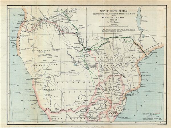
Map of South Africa Illustrating the Journey of Major Serpa Pinto from Benguella to Natal 1877-79.
1879 (dated) 9 x 12 in (22.86 x 30.48 cm)
1879 (dated) 9 x 12 in (22.86 x 30.48 cm)
Description
This is an uncommon 1879 map of central Africa by A. K. Johnston. Illustrating the journey of the Portuguese explorer Major Serpa Pinto, this map covers from the Atlantic Ocean to the Indian Ocean and from Njambi to Cape Colony. It includes the modern day African nations of Mozambique, Zimbabwe, Botswana, and Namibia. The routes traversed by Serpa Pinto (Benguella to Natal from 1877 to 1879), David Livingstone, (Zambezi River, 1849 to 1860) and Verney Lovatt Cameron (Zambezi River, 1873 to 1875) are identified with color coding. The mission town of Livingstonia (Kondowe), named after the missionary David Livingstone, is noted at the southern tip of Lake Nyassa or Lake Malawi. British colonies are highlighted in red and Portuguese colonies in brown. Victoria Falls (along with its indigenous name, Mosi-oa-Tunya), the Ruins of Zumbo, and the Kalahari Desert are all identified. Alexandre de Serpa Pinto recorded his travels across Africa in a book entitled 'How I crossed Africa.' He was later appointed governor of Mozambique in 1889. This map was drawn by A. K. Johnston and published by e. Stanford with contributions from W. J. Turner, for issue in the 1879 Proceedings of the Royal Geographical Society and Monthly Record of Geography.
CartographerS
Alexander Keith Johnston (December 28, 1804 - July 9, 1871) was a Scottish cartographer and map publisher active in the middle portion of the 19th century. Johnson was born at Kirkhill, near Edinburgh, Scotland. He studied at the University of Edinburgh where he apprenticed as an engraver. Around 1826, in partnership with his brother William, he founded a cartographic printing and engraving firm with the imprint "W. and A. K. Johnston." Johnston made a name for himself in educational geography, publishing numerous maps for use in schools. His brother, William Johnston, eventually left the firm to pursue a career in politics, eventually becoming the Lord Provost of Edinburgh. Alexander's son, who would bear the same name, became a geographer and explorer, suffering an untimely death on the Royal Geographical Society's 1879 expedition to Lake Nyasa. More by this mapmaker...
Edward Stanford (May 27, 1827 - November 3, 1904) was one of the most prolific map publishing firms of the late 19th century. The company began as a partnership in 1848 between the 21 year old Edward Stanford and the established map dealer Trelawney Saunders. By 1853 the partnership had dissolved and Edward Stanford took full control of the business. A subsequent series of expansions and exciting new map issues finally led to the production of Stanford's masterwork, "Stanford's Library Map of London". This map is still available and remains somewhat accurate. At the time of publishing it was hailed by the Royal Geographical Society as "the most perfect map of London that has ever been issued". In 1882 Edward Stanford Sr. passed the firm on to his son, Edward Stanford Jr. who continued in his father's proud tradition. Today the Stanford firm still publishes maps and remains one of the most important and prolific cartographic publishers in the world. Learn More...
Source
Stanford, E. Proceedings of the Royal Geographical Society and Monthly Record of Geography, Vol. 1, 1879.
Condition
Very good. Minor wear and toning on original fold lines.
References
Bassett, T., and Scheven, Y., Maps of Africa to 1900 : a checklist of maps in atlases and geographical journals in the collections of the University of Illinois, Urbana-Champaign, 910.6RLn.s./rbx.