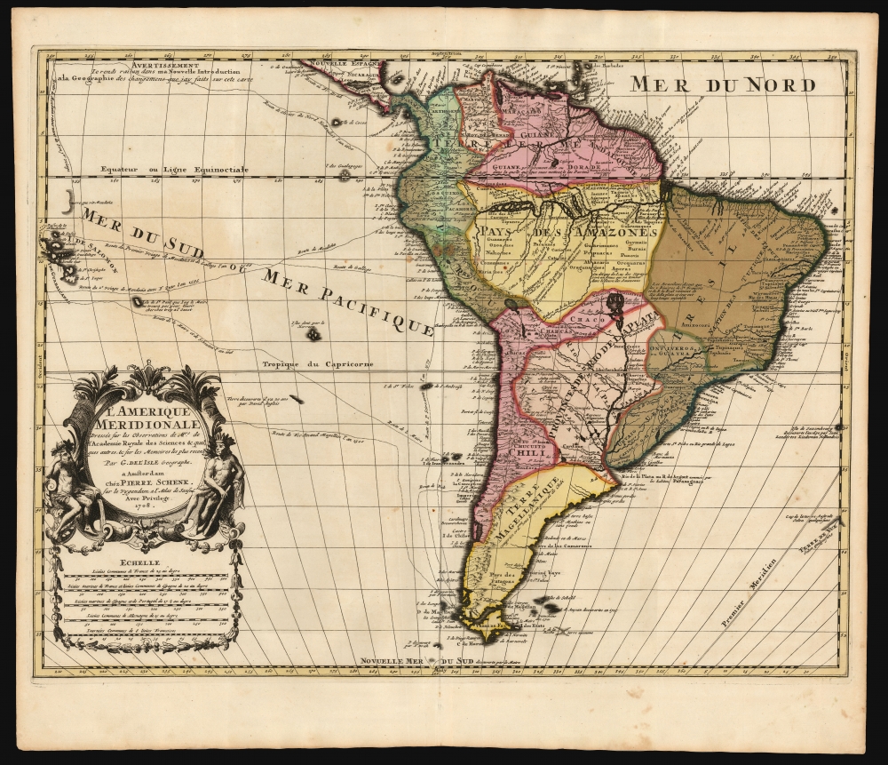
1708 De l'Isle / Schenk Map of South America
SouthAmerica-delisleschenk-1708
Title
1708 (undated) 17.5 x 23 in (44.45 x 58.42 cm) 1 : 19500000
Description
A Closer Look
The map covers from Costa Rica and Barbados south to beyond Tierra del Fuego. The coastline boasts exceptional detail. The Amazon Basin is similar to that found on Coronelli's maps and is likewise derived from late-17th-century French Jesuit relations. The present work diverges from the previous century's maps of South America by its excision of Parime Lacus, a legendary lake in Guiana, and the supposed location of El Dorado. Instead, the great inland sea Parima is replaced by notes and the smaller 'Lake Cassipa', an early name of the factual Lake Amaku.Lago de Xarayes
The map does include a prominent Lago de Xarayes at the head of the Paraguay River. The Xarayes (a corruption of Xaraiés, meaning Masters of the River) were an indigenous people occupying what are today parts of Brazil's Matte Grosso and the Pantanal. When Spanish and Portuguese explorers first navigated up the Paraguay River, as always in search of El Dorado, they encountered the vast Pantanal flood plain at the height of its annual inundation. Understandably, they misinterpreted the floodplain as a gigantic inland sea, which they named after the local tribes, the Xaraies. The Laguna de los Xarayes almost immediately began to appear on early maps of the region and, at the same time, took on a legendary aspect. Later missionaries and chroniclers, particularly Díaz de Guzmán, imagined an island in this lake and curiously identified it as a Paradise.Sanson?
An odd feature of this map's title is the reference in the cartouche to the atlas of Nicolas Sanson - who had died in 1667, and whose geography for this region had been obsolete 20 years prior to De l'Isle's 1700 map. Sanson's maps of North America bore no resemblance to De l'Isle's work. To be fair, Sanson was, in his day, a towering geographical authority, and his reputation was such that Schenk's atlas (in this map would be inserted) was titled Atlas Contractus sive Mapparum Geographicarum Sansoniarum auctarum et correctarum nova congeries. Schenk would not be the only turn-of-the-century map publisher to drop the great geographer's name amongst collections of maps otherwise unconnected with him, and indeed, there exist copies of De l'Isle's North America attributed to Sanson in the imprint.Publication History and Census
This map was engraved for Peter Schenk for inclusion in his 1708 Atlas Contractus.... It is one of the earliest derivatives of De l'Isle's 1700 map, which was widely copied. It is neglected by institutional collections, with one example cataloged by the University of Wisconsin. It appears on the market from time to time but rarely in such strikingly beautiful condition.CartographerS
Guillaume De l’Isle (1675 - 1726) was a French cartographer, and arguably the finest mapmaker at the beginning of the eighteenth century. He was the son of Claude De L'Isle (1644 -1720), a Paris-based historian and geographer under Nicholas Sanson, then the leading light of French cartography. He was the chief proponent of the school of 'positive geography' and the primary figure defining the heights of the Golden Age of French Cartography. Guillaume's skill as a cartographer was so prodigious that he drew his first map at just nine years of age. He was tutored by J. D. Cassini in astronomy, science, mathematics and cartography. By applying these diverse disciplines to the vast stores of information provided by 18th century navigators, Guillaume created the technique that came to be known as 'scientific cartography', essentially an extension of Sanson's 'positive geography'. This revolutionary approach transformed the field of cartography and created a more accurate picture of the world. Among Guillaume's many firsts are the first naming of Texas, the first correct map of the Mississippi, the final rejection of the insular California fallacy, and the first identification of the correct longitudes of America. Stylistically De L'Isle also initiated important changes to the medium, eschewing the flamboyant Dutch style of the previous century in favor of a highly detailed yet still decorative approach that yielded map both beautiful and informative. Guillaume was elected to the French Academie Royale des Sciences at 27. Later, in 1718, he was also appointed 'Premier Geographe du Roi', an office created especially for him. De L'Isle personally financed the publication of most of his maps, hoping to make heavy royalties on their sales. Unfortunately he met an untimely death in 1728, leaving considerable debt and an impoverished child and widow. De L'Isle's publishing firm was taken over by his assistant, Phillipe Buache, who would also become his son in law. More by this mapmaker...
Petrus Schenk (Pieter Schenck) the Elder (December 26, 1660 - 1711) was a Dutch engraver, globe maker, and map publisher active in Amsterdam and Leipzig in the latter half of the 17th century. Schenk, was born in Elberfield, Germany. He moved in Amsterdam in 1675, becoming the apprentice to Gerard Valk (Valck). In 1687, Schenk married Agatha Valk, Gerard Valk's sister and went into partnership with his brother-in-law under the imprint of 'Valk and Schenk'. Initially they focused on maps and atlases, acquiring the map plates of Jan Jansson and Jodocus Hondius in 1694. Later, in 1701 they moved into the former Hondius offices where they began producing globes. Valk and Schenk quickly became known for producing the best globes in the Netherlands, a business on which they held a near monopoly for nearly 50 years. Schenk's three sons, Pieter Schenk the Younger, Jan Schenk, and Leonard Schenk, all became engravers in their own right. Pieter Schenk the Younger inherited the business and ran his father's shop in Leipzig. His daughter, Maria Schenk, married Leonard Valk, the son of Gerard Valk, and continued to run the Valk and Schenk map engraving workshop in Amsterdam. Learn More...

