1847 Perthes / Alt Ethnographic and Linguistic Map of South America
SouthAmericaEthnographic-perthes-1847$375.00

Title
Ethnographische Karte von Süd-Amerika...
1847 (dated) 11.5 x 14.25 in (29.21 x 36.195 cm) 1 : 28000000
1847 (dated) 11.5 x 14.25 in (29.21 x 36.195 cm) 1 : 28000000
Description
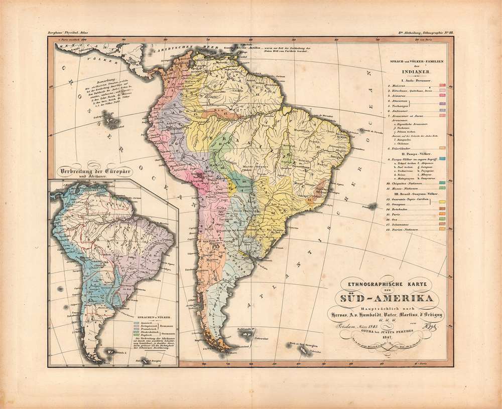
A fascinating 1847 ethno-linguistic map of South America by Wilhelm Alt for Berghaus' Physikalischer Atlas, a landmark achievement in German cartography. It reflects the intellectual environment of the mid-19th century and, along with the entire atlas, can be regarded as an early example of cartographic representation of social science research.
Despite the title, the data represented focuses more on linguistic than ethnic or 'racial' groups, perhaps because the latter was especially complicated in the American context and would have been near impossible to represent visually. Indeed, although the map and the inset at bottom-left implicitly allude to this question, there is no mention of the race-based social hierarchy of South American societies, nor the social categories produced by the New World context (creoles, mestizos, mulattoes). The inset shows the 'Distribution of Europeans and Africans,' in fact displaying two distinct sets of data: the distribution of European languages and the density of the 'African' population in different parts of the continent.
A note near top-left discusses 'civilized states' of South America at the onset of European colonization, with one being the well-known Incas, the descendants of which are represented by numbers 2-5 in the table, and the lesser-known Muiscas, number 1 in the table. The Muiscas formed a loose confederation in the Central Andean Highlands (in modern-day Colombia), some local rulers of which were known as Zaque, the origin of the German term Zake Reich.
A few more points of interest are worth mentioning. The names of some peoples here are rooted in indigenous terms, others are descriptive (such as Feüerländer), while others appear to be wholly imported and did not become standard (such as the 'Schumanas' people). The map dates to a brief period when Manaus, at the meeting of the Solimões and Negro Rivers, which forms the beginning of the Amazon proper, was called Cidade da Barra do Rio Negro, the reason for its uncommon designation as Barra here. Finally, it is noteworthy that Paris is used as a Prime Meridian not Berlin, though the reason for this choice is unclear.
A Closer Look
The map shows the prevailing indigenous groups in different parts of South America. Information is mentioned as being drawn mainly from (Lorenzo) Hervas, (Alexander von) Humboldt, (Johann Severin) Vater, (Carl von) Martius, and (Alcide) d'Orbigny. Humboldt played an especially important role in this map and the atlas in which it appeared. Not only would he have been familiar to readers, as he was one of the most prominent German intellectuals of his day, he also was a friend of the author, Berghaus, and had traveled extensively in South America in the early 19th century, undertaking scientific observations and geographic explorations.Despite the title, the data represented focuses more on linguistic than ethnic or 'racial' groups, perhaps because the latter was especially complicated in the American context and would have been near impossible to represent visually. Indeed, although the map and the inset at bottom-left implicitly allude to this question, there is no mention of the race-based social hierarchy of South American societies, nor the social categories produced by the New World context (creoles, mestizos, mulattoes). The inset shows the 'Distribution of Europeans and Africans,' in fact displaying two distinct sets of data: the distribution of European languages and the density of the 'African' population in different parts of the continent.
A note near top-left discusses 'civilized states' of South America at the onset of European colonization, with one being the well-known Incas, the descendants of which are represented by numbers 2-5 in the table, and the lesser-known Muiscas, number 1 in the table. The Muiscas formed a loose confederation in the Central Andean Highlands (in modern-day Colombia), some local rulers of which were known as Zaque, the origin of the German term Zake Reich.
A few more points of interest are worth mentioning. The names of some peoples here are rooted in indigenous terms, others are descriptive (such as Feüerländer), while others appear to be wholly imported and did not become standard (such as the 'Schumanas' people). The map dates to a brief period when Manaus, at the meeting of the Solimões and Negro Rivers, which forms the beginning of the Amazon proper, was called Cidade da Barra do Rio Negro, the reason for its uncommon designation as Barra here. Finally, it is noteworthy that Paris is used as a Prime Meridian not Berlin, though the reason for this choice is unclear.
Publication History and Census
This map is attributed to Wilhelm Alt in Ohrdruff (that is, Gotha) and was included in Part 8, No. 18 'Ethnography' of Berghaus' Physikalischer Atlas, published by Justus Perthes. It is dated as being drawn at the Geographische Kunstschule in March 1845 in Potsdam and published in Gotha in 1847. Berghaus had founded the Geographische Kunstschule and it is possible that Alt was one of his pupils who went on to work for Justus Perthes. Berghaus' Physikalischer Atlas was initially published as an addendum to Humboldt's extremely popular and influential book Kosmos, which incidentally was strongly influenced by his travels in the Americas. With the publicity attracted by its association with Humboldt, Berghaus' atlas quickly became well-known and was regarded as a triumph in its thorough research, coverage of a wide range of subjects, and clever methods for presenting large amounts of data. This map is only cataloged as belonging to the holdings of a small handful of libraries in Germany and it is scarce to the market.CartographerS
Johan Georg Justus Perthes (September 11, 1749 - May 2, 1816) was one of the most important German cartographic engravers of the 19th century. He was born in the Thuringian town of Rudolstadt, the son of a court physician. In 1778, he began working as a bookseller in Gotha. Perthes began his publishing empire shortly thereafter with the 1784 issue of the famed survey of European nobility known as the Almanac de Gotha. In the next year, 1785, he founded the cartographic firm of Justus Perthes Geographische Anstalt Gotha. His son Wilhelm Perthes (1793 - 1853) joined the firm in 1814. Wilhelm had prior publishing experience at the firm of Justus Perthes' nephew, Friedrich Christoph Perthes, who ran a publishing house in Hamburg. After Justus Perthes died in 1816, Wilhelm took charge and laid the groundwork for the firm to become a cartographic publishing titan. From 1817 to 1890. the Perthes firm issued thousands of maps and more than 20 different atlases. Along with the visionary editors Hermann Berghaus (1797 - 1884), Adolph Stieler (1775 - 1836), and Karl Spruner (1803 - 1892), the Perthes firm pioneered the Hand Atlas. When Wilhelm retired, management of the firm passed to his son, Bernhardt Wilhelm Perthes (1821 – 1857). Bernhardt brought on the cartographic geniuses August Heinrich Peterman (1822 - 1878) and Bruno Hassenstein (1839 - 1902). The firm was subsequently passed to a fourth generation in the form of Berhanrd Perthes (1858 – 1919), Bernhard Wilhelm's son. The firm continued in the family until 1953 when, being in East Germany, it was nationalized and run as a state-owned enterprise as VEB Hermann Haack Geographisch-Kartographische Anstalt Gotha. The Justus family, led by Joachim Justus Perthes and his son Wolf-Jürgen Perthes, relocated to Darmstadt where they founded the Justus Perthes Geographische Verlagsanstalt Darmstadt. More by this mapmaker...
Wilhelm Alt (fl. c. 1827 – 1882) was a German cartographer associated with Justus Perthes, based in Gotha. He is credited as the creator of over one hundred maps published by Perthes, especially those in the atlases of Karl Spruner von Merz, Adolf Stieler, and Heinrich Berghaus, though little is known about his life and training. Learn More...
Heinrich Karl Wilhelm Berghaus (May 3, 1797 – February 17, 1884) was a German (Prussian) geographer who founded the Geographische Kunstschule in Potsdam and trained several important German geographers and cartographers of the late 19th century, including August Heinrich Petermann and his nephew Hermann Berghaus. The elder Berghaus also was a friend and associate of Alexander von Humboldt, producing some of the maps in his publications. In 1837, he inherited the Daniel Gottlob Reymann (1759 – 1837) monumental Geographischer Specialatlas von Deutschland. Berghaus is best known for his own influential and wide-ranging atlases, namely Atlas von Asien, published between 1833 and 1837, and Berghaus' Physikalischer Atlas, published in multiple editions in the 1830s - 1840s. Although Atlas von Asien was a commercial failure, it was regarded as a work of supreme quality, boosting the reputation of the publisher Justus Perthes and setting up their next collaboration, Berghaus' Physikalischer Atlas, for success. Learn More...
Source
Berghaus, H., Berghaus' Physikalischer Atlas (Gotha: J. Perthes) 1847.
Condition
Good. A few old fold lines. Periodic foxing.
References
Rumsey 2515.081. OCLC 632650173, 165437157.