1763 Mount and Page 'English Pilot' Chart or Map of South Carolina
SouthCarolina-mountpage-1763$4,500.00

Title
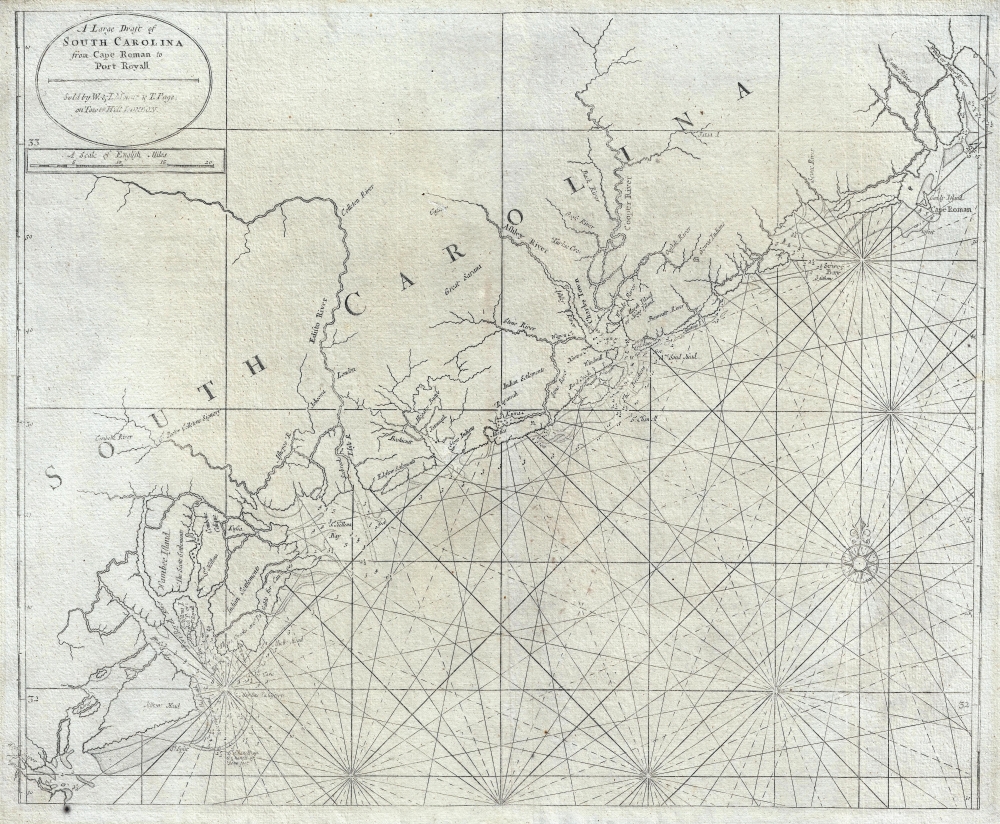
A Large Draft of South Carolina from Cape Roman to Port Royall.
1763 (undated) 18 x 22 in (45.72 x 55.88 cm) 1 : 316800
1763 (undated) 18 x 22 in (45.72 x 55.88 cm) 1 : 316800
Description
A rare 1763 Mount and Page nautical chart or maritime map of the coast of South Carolina issued at the end of the French and Indian War (1754 - 1763). Centered on Charleston (Charles Town), the map covers from the Santee River and Cape Romain (Cape Roman) to Hilton Head and Port Royal - a prosperous area covering the main ports of the cotton and tobacco trade. The cartographer notes various Indian and European Settlements, including the Scotts Settlements, Sr. Peter Colleons Signory, the Edestow Setlements (Edisto Settlements), the site of a Sewee Indian village, and more. There are soundings along much of the coastline, but particularly concentrated around Charleston and Port Royal
This map exists in three known states, all of which are identical with the exception of the imprint:
Publication History and Census
This chart was first drawn by John Thornton and issued in the 1706 edition of the English Pilot, the Fourth Book. Thornton derived the basic cartography from the 1685 manuscript map of Maurice Mathews (1694), leader of the notorious Barbadian planter gang, the 'Goose Creek Men.' The present example is the third state, issued by Mount and Page is 1863 or 1864.This map exists in three known states, all of which are identical with the exception of the imprint:
- State 1 - 1706 - bears John Thornton Imprint.
- State 2 - 1716 - bears John Thornton Imprint.
- State 3 - 1763/4 - bears Mount and Page imprint.
CartographerS
Mount and Page (fl. 1701 - 1760) was a London based firm of religious and maritime publishers that flourished in the 18th century. With the publication of the 1732 English Pilot, the Mount and Page name became well-known worldwide as an imprint of nautical charts. The firm was founded at Tower Hill, London, in 1701 by Richard Mount (1654 - 1722) and his apprentice Thomas Page (1780 - March 15, 1733). Mount had previously been in partnership with his father-in-law William Fisher (1631 - 1691) and inherited the business on the latter's death. Page completed his apprenticeship in 1716. Now fully partnered, Mount and Page subsequently acquired the map plates several defunct British nautical chart publishers, including Greenville Collins, Jeremiah Seller, Charles Price, and John and Samuel Thornton - thus nearly monopolizing the British nautical chart business. The firm consequently received several lucrative government contracts and thereby flourished throughout the 18th century, making the fortunes of both families. Successive generations of Mounts and Pages worked in the business, and the families intermarried. Its staple titles were The English Pilot and Navigatio Britannica by John Barrow. By the 1760s, Richard Mount's grandson John Mount (1725 - 1786) was able to retire to Berkshire where he built the stately mansion, Wasing Place. John's son William (1753 - 1815) was the last to work in the map business, and later generations went into politics. More by this mapmaker...
John Thornton (October 8, 1641 - January 23, 1708) was a British chartmaker, sea captain, publisher and engraver active in London during the late 18th and early 19th centuries. Thornton apprenticed to John Burston where mastered the art of manuscript maritime cartography as practiced by the Thames School. By the 1660s Thornton, working with John Seller and William Fisher, began publishing printed nautical charts and was the only Thames School cartographers to successfully transition to print. Thornton published numerous maps both independently and with some of the most prominent British publishers of his day, including the aforementioned as well as Herman Moll, Robert Morden, James Clark, Robert Greene, and Philip Lea. From around 1665 Thornton took over from Seller the production of the English Pilot. Upon his death in 1708 Thornton willed his charts, copper plates, instruments, and 'all things belonging to my calling' to his son, Samuel Thornton, who continued to republished his father's work, with few updates, until about 1715. Learn More...
Source
The English Pilot. Fourth Book, (London: Mount and Page) 1763.
Condition
Very good. Some uneven toning. Light impression.
References
OCLC 948604320. Phillips (America) page 419. Cumming, W., The Southeast in Early Maps, #144.