This item has been sold, but you can get on the Waitlist to be notified if another example becomes available, or purchase a digital scan.
1778 Andrew Hughes Map of the Georgia, South Carolina, and Florida
SouthCarolinaGeorge-hughes-1778-2$2,250.00

Title
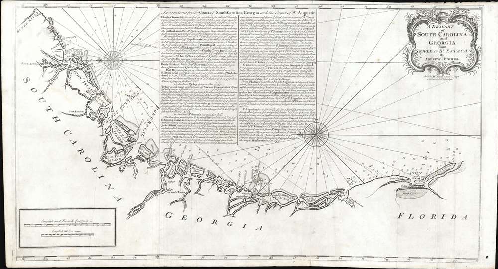
A Draught of South Carolina and Georgia from Sewee to St. Estaca.
1778 (undated) 18 x 32.75 in (45.72 x 83.185 cm) 1 : 450000
1778 (undated) 18 x 32.75 in (45.72 x 83.185 cm) 1 : 450000
Description
A rare and important 1778 American Revolutionary War era Andrew Hughes nautical chart or maritime map of the coasts of South Carolina, Georgia, and northern Florida. During the early part of the Revolutionary War, this was the best obtainable nautical chart of the Sea Islands. Oriented to the east, this stunning map covers the Atlantic coast from the Santee River (Sewee River), South Carolina, past Charleston, Beaufort, and Savannah, to Saint Augustine, Florida. In addition, the map offers extensive and valuable piloting instructions addressing the entire coastline as well as most individual islands, including Tybee Island, Amelia Island, and Sapelo Island. It also includes excellent coverage of the region's shoals, anchorages, currents, marsh lands, river estuaries, and tides marks.
Publication History and Census
The chart is credited to Andrew Hughes, of whom we have been able to learn little. There was an man of this name active in South Carolina during the American Revolutionary War, but no evidence that he had any nautical surveying experience. It first appeared in the 1778 edition of Mount and Page's English Pilot, the Fourth Book, replacing A Large Draught of South Carolina. It represents a significant step forward in the cartography of this coastal region both in terms of greater accuracy and expanded coverage. Despite this, the map appeared in only a few Revolutionary War Era editions of the English Pilot and is consequently extremely scarce.Cartographer
Mount and Page (fl. 1701 - 1760) was a London based firm of religious and maritime publishers that flourished in the 18th century. With the publication of the 1732 English Pilot, the Mount and Page name became well-known worldwide as an imprint of nautical charts. The firm was founded at Tower Hill, London, in 1701 by Richard Mount (1654 - 1722) and his apprentice Thomas Page (1780 - March 15, 1733). Mount had previously been in partnership with his father-in-law William Fisher (1631 - 1691) and inherited the business on the latter's death. Page completed his apprenticeship in 1716. Now fully partnered, Mount and Page subsequently acquired the map plates several defunct British nautical chart publishers, including Greenville Collins, Jeremiah Seller, Charles Price, and John and Samuel Thornton - thus nearly monopolizing the British nautical chart business. The firm consequently received several lucrative government contracts and thereby flourished throughout the 18th century, making the fortunes of both families. Successive generations of Mounts and Pages worked in the business, and the families intermarried. Its staple titles were The English Pilot and Navigatio Britannica by John Barrow. By the 1760s, Richard Mount's grandson John Mount (1725 - 1786) was able to retire to Berkshire where he built the stately mansion, Wasing Place. John's son William (1753 - 1815) was the last to work in the map business, and later generations went into politics. More by this mapmaker...
Source
The English Pilot. Fourth Book, (London: Mount and Page) 1778.
Condition
Very good. A few minor verso reinforcements. Light transferrence.
References
Verner, C., A Carto-Bibliographical Study of The English Pilot The Fourth Book,#61. Philips (Atlases), Vol. 1, 1168, # 13 and 1171, # 14. Sellers, John R. and Van Ee, Patricia, Maps and Charts of North America, #1399. OCLC 945093316.