
1945 C.P.D. Indian WWII Map of Southern China, Taiwan, French Indochina, and Eastern India

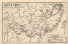
South China. Map 254.
India-published map of the Japanese WWII positions in China as of February 1945.
$300.00
Choose a Collection:
- Digital Map Information
- Suitable for large format printing
- Full resolution TIFF file
- ICC color profile embedded
- Delivered instantly via download link
This Item
Enquire
India-published map of the Japanese WWII positions in China as of February 1945.
This is a February 1, 1945, Indian-imprint 'C.P.D.' map of southern China and Taiwan (Formosa), along with parts of French Indochina, Burma (Myanmar), Siam (Thailand), and India. The map illustrates the high-water mark of Japanese control over China on the cusp of major Allied offensives to retake the region. The focus is on the Hanoi-Changsha-Wuhan railway corridor, the key north-south transport artery through central China.A Closer Look
Centered on the strategic Hanoi-Changsha-Wuhan railway corridor, coverage embraces from Myingyan, Burma, east to Luzon (an island in the Philippines) and from Chinkiang (Zhenjiang), China, to Hainan Island. Cities labeled include Shanghai, Nanking (Nanjing), Hangchow (Hangzhou), Hankow (Hankou), Foochow (Fuzhou), Hanoi, Wuhan (Wuchang), and Canton (Guangzhou). Roads, railways, and rivers are illustrated.Depicting the War
Lines of triangles mark the approximate position of the Japanese armies as of February 1, 1945, with lines stretching from just north of Myingyan through Burma and then north through China. The Japanese controlled Nanking, Shanghai, and Hankow, as well as all the major Chinese coastal cities. The Allies liberated Myingyan and Mandalay in March 1945, and Rangoon was liberated in April.Hanoi-Changsha-Wuhan Railway Corridor
Although it changed hands several times over the course of WWII, when this map was issued, February 1, 1945, the Hanoi-Changsha-Wuhan railway corridor was essentially under Japanese control from end to end. Vichy France nominally administered Hanoi and northern Indochina, but Japanese forces dominated the region and controlled key infrastructure (with the formal Japanese coup coming in March 1945). In China, Japan held the rail routes through Guangxi and Hunan following its 1944 Operation Ichi-Go offensive, including Changsha, while Wuhan (including Wuchang) had been under Japanese occupation since its fall in 1938.Verso Map
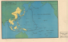
The map on the verso depicts from Bombay (Mumbai) in India to the west coast of North America. Yellow highlights the farthest extent of the Japanese advance across the Pacific and underscores that the Japanese did not occupy all of southern China.Publication History and Census
This map was published in India c. 1945 and drawn by a draftsman or agency identified only as 'C.P.D'. It is however part of a series, see our NorthChina-rrd-1945. We are aware of one other example in private hands.Condition
Very good. Light wear along original fold lines. Map of Asia and the Pacific Ocean on verso.