This item has been sold, but you can get on the Waitlist to be notified if another example becomes available, or purchase a digital scan.
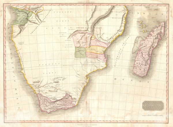
1818 Pinkerton Map of Southern Africa ( Congo, Monomotapa, Cape Colony )
SouthernAfrica-pinkerton-1818$175.00

Title
Southern Africa.
1818 (undated) 20 x 28 in (50.8 x 71.12 cm)
1818 (undated) 20 x 28 in (50.8 x 71.12 cm)
Description
This fascinating hand colored 1818 map by Edinburgh cartographer John Pinkerton depicts Southern Africa. Covers Africa from Angola south to the Cape Colony (modern South Africa) and east to the Kingdom of Mongall (modern day Mozambique) and the island of Madagascar. Reflecting the somewhat limited knowledge of the African interior available to European cartographers of the period, only three areas are illustrated with any detail - the Congo, the Cape Colony (South Africa) and the former Kingdom of Monomotapa, which roughly overlaps modern day Mozambique.
The Congo had been actively mapped and exploited by Portuguese merchants as early as the 14th century. South Africa, similarly, had an active Dutch and English presence since the earliest days of African Colonization.
The ancient Kingdom of Monomotapa, here part of the Empire of the Bororos and divided into Sabia, Sofala, Munhay and Manica, appears on most early maps of Africa. Already a great trading Empire when Vasco de Gama rounded the Cape of Good hope in the 1490s, Monomotapa or the regions between the Sabia, Sofala and Zambezi River systems, had long been associated with legends of King Solomon's Mines and the Biblical lands of Ophir. In the 15th century the Zambezi hills were indeed rich in gold, but these deposits had run out by the 1600s. Still, the European imagination, inflamed by conquistador tales of golden empires in America, made several attempts to conquer the region, only to find that there was no more gold to be had.
In other areas of Africa's interior Pinkerton notes an embryonic Lake Malawi (named Maravi), and notes several important African tribal nations, including the Massai, the Hottentots, the Bembe, and the Luba (Lubolo).
Drawn by L. Herbert and engraved by Samuel Neele under the direction of John Pinkerton. This map comes from the scarce American edition of Pinkerton's Modern Atlas, published by Thomas Dobson & Co. of Philadelphia in 1818.
CartographerS
John Pinkerton (February 17, 1758 - March 10, 1826) was an Scottish writer, historian, and cartographer. Pinkerton was born in Edinburgh, Scotland. He was a studious youth with a passion for the classics. As a young man, he studied at Edinburgh University before apprenticing as a lawyer. Around this time, he began writing, with his first book, Elegy on Craigmillar Castle published in 1776. Pinkerton moved to London in 1781 to pursue his writing career in earnest. He successfully published several works of literature, poetry, and history. Pinkerton proved passionate in his literary and historical writings, but his correspondence with other cartographers has been labeled as aggressive, even insane. In addition to his work as a writer and historian, Pinkerton was one of the leading masters of the Edinburgh school of cartography which flourished from roughly 1800 to 1830. Pinkerton and his contemporaries (Thomson and Cary) redefined European cartography by abandoning typical 18th century decorative elements such as elaborate title cartouches and fantastical beasts in favor of detail and accuracy. Pinkerton's principle work is Pinkerton's Modern Atlas published from 1808 through 1815 with a special American reissue by Dobson and Co. in 1818. Pinkerton relocated to Paris in 1818, where he managed his publishing business until his death in 1826. More by this mapmaker...
Thomas Dobson (1751 - 1823) was an American publisher active in Philadelphia during the late 18th and early 19th centuries. Dobson was born in Edinburgh, Scotland in 1751 and emigrated to Philadelphia c. 1780. In Philadelphia, he established a successful printing business by republishing edited and updated versions of important British reference materials in matching quality but at a much lower price point. He is best known for publishing the first American edition of the Encyclopedia Britannica. He also published America's first Hebrew Bible. Cartographically Dobson's most notable work is 1818 republication of Pinkerton's fantastic Modern Atlas. Learn More...
Source
Pinkerton, J., A Modern Atlas, from the Lates and Best Authorities, Exhibiting the Various Divisions of the World with its chief Empires, Kingdoms, and States; in Sixty Maps, carefully reduced from the Larges and Most Authentic Sources. 1818, Philadelphia, Thomas Dobson Edition.
Condition
Very good condition. Minor discoloration along original centerfold. Minor dampstaining in lower quadrants. Blank on verso.
References
Tooley, R. V., Printed Maps of Southern Africa and its Parts, 230. Rumsey 0732.061. Phillips (Atlases) 724. National Maritime Museum, 409.