1844 Copley Blueback Nautical Chart or Maritime Map of the Bahamas and Cuba
SouthernCoast-copley-1844$950.00

Title
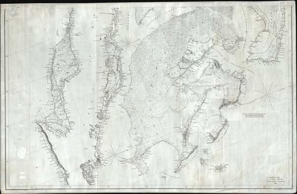
Southern Coast, U. States. Sheet VIII.
1844 (dated) 26 x 40 in (66.04 x 101.6 cm) 1 : 1222858
1844 (dated) 26 x 40 in (66.04 x 101.6 cm) 1 : 1222858
Description
This is an 1844 Edmund and George William Blunt map of the Bahamas and eastern Cuba. The map depicts the Caribbean from just south of Cuba to Great Abaco, Little Abaco, and the cays to the east of Great Abaco and from the Sagua la Grande River, Cuba and Great Bahama to just east of Santiago de Cuba and Watlings Island. Numerous locations are labeled along the Cuban coast on this highly detailed chart, with a detailed depiction of the small islands and cays situated along the Cuban coastline. The islands of the Bahamas are as meticulously illustrated, with coastal locations, channels, sounds, cays, small islands and other hazards charted. Myriad depth soundings are included, particularly within the Greater Bahama Bank. A note stating the best courses across the Bank is situated on the right side of the map, just below Eleuthera Island.
Blueback Charts
Blueback nautical charts began appearing in London in the late 18th century. Bluebacks, as they came to be called, were privately published large format nautical charts known for their distinctive blue paper backing. The backing, a commonly available blue manila paper traditionally used by publishers to warp unbound pamphlets, was adopted as a practical way to reinforce the low-quality paper used by private chart publishers in an effort to cut costs. The earliest known blueback charts include a 1760 chart issued by Mount and Page, and a 1787 chart issued by Robert Sayer. The tradition took off in the early 19th century, when British publishers like John Hamilton Moore, Robert Blachford, James Imray, William Heather, John William Norie, Charles Wilson, David Steel, R. H. Laurie, and John Hobbs, among others, rose to dominate the chart trade. Bluebacks became so popular that the convention was embraced by chartmakers outside of England, including Americans Edmund March Blunt and George Eldridge, as well as Scandinavian, French, German, Russian, and Spanish chartmakers. Blueback charts remained popular until the late 19th century, when government subsidized organizations like the British Admiralty Hydrographic Office and the United States Coast Survey, began issuing their own superior charts on high quality paper that did not require reinforcement.Publication History and Census
This map was drawn and engraved by Charles Copley and published by Edmund and George William Blunt in New York in 1844. This chart appears to be half of a larger chart, the other half of which we have not previously encountered.CartographerS
Charles Copley (1800 - November 17, 1880), was an American nautical chart and globe publisher based in Brooklyn, New York and active in the middle part of the 19th century. He was born in England and emigrated to the United States in the 1840s. He became a citizen in 1844. Charles Copley's earliest work is associated with the firm of E. and G. W. Blunt and his name appears as hydrographer or engraver on several of Blunt's c. 1840 charts – so he must have began working the Blunt shortly after emigrating. Around 1847 Copley began publishing independently, advertising himself as an engraver and map publisher. Most of his independent work was published in the 1850s. By 1860, the firm renamed itself Charles Copley and Son's, accommodating Charles John Copley Jr. (1826 - 18xx) and Frederick S. Copley (1827 - 18xx). From this point forward, most charts are copyrighted by 'C.C.J and F.S. Copley.' All Copley charts are extremely rare. More by this mapmaker...
Edmund March Blunt (June 20, 1770 - 1862) was an American navigator, bookseller, chartmaker, and cartographer based in Newburyport, Massachusetts. Blunt was born in Portsmouth, New Hampshire in 1770. In 1796, along with the nominal assistance of prominent navigator Captain Lawrence Furlong, Blunt published The American Coast Pilot, one of the most important published works on American navigation. Although much of the work was plagiarized from British publications, the Coast Pilot was an immediate popular success. In response to the popularity of his work, Blunt published 21 subsequent editions, each with important updates and revisions. The first edition to contain map plates was printed in 1804. Following a fire that destroyed his offices at The Sign of the Bible in 1811, Blunt moved his business to New York and opened a new shop, The Sign of the Quadrant. His sons Edmund Jr. (1799 - 1866) and George William (1802 - 1878), joined the firm in 1824 and eventually took over the family business, renaming the firm 'E. and G. W. Blunt'. They both produced their own nautical books, charts, and instruments, as well as republished their father’s work. In 1830, Edmund accepted a position under Ferdinand Hassler at the United States Office of the Coast Survey. Much of Blunt's original work eventually found its way into U.S. Coast Survey Publications. George closed the firm in 1872 and sold the plates and chart copyrights to the U.S. Coast Survey and the U.S. Navy Hydrographic Office. Due to the quality and detail of Blunt's work, revised editions of his most important charts were republished well into the 1880s. Learn More...
Condition
Good. Patched holes along left margin. Wear along top margin. Blank on verso.