This item has been sold, but you can get on the Waitlist to be notified if another example becomes available, or purchase a digital scan.
1926 Poole Brothers Railroad Map of Florida and the Southern Railway System
SouthernRailwaySystem-poolebros-1926$200.00

Title
Southern Railway System 'The Way to Florida'.
1926 (dated) 28.5 x 17.5 in (72.39 x 44.45 cm) 1 : 1267200
1926 (dated) 28.5 x 17.5 in (72.39 x 44.45 cm) 1 : 1267200
Description
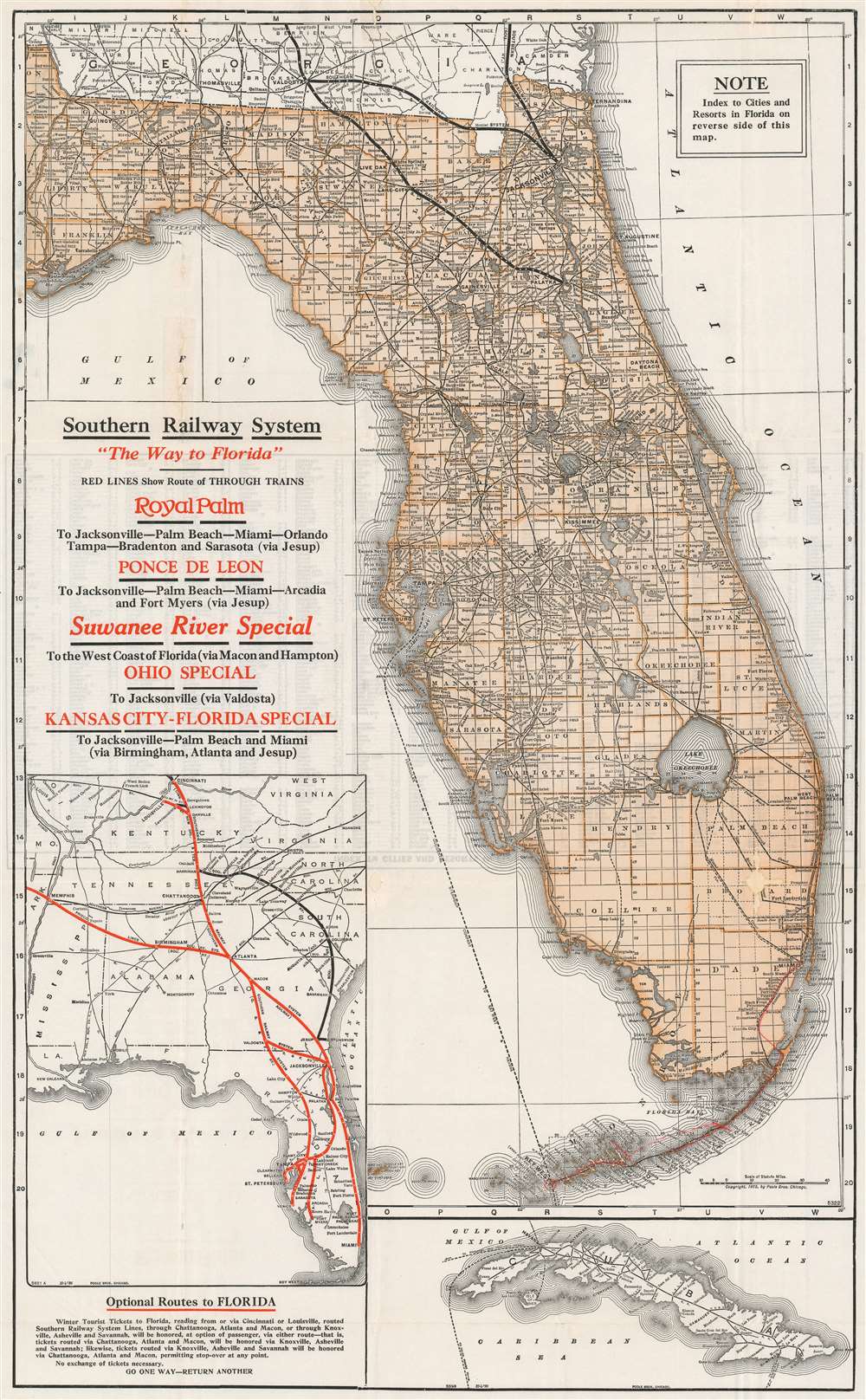
This is a 1926 Poole Brothers railroad map of Florida published by the Southern Railway System. Routes owned by Southern Railway and its subsidiaries in northern Florida are emphasized by illustrating them with thick black lines. The rest of the railroad network in Florida is depicted using thin place lines to mark the routes, all of which are labeled with block lettering, including the Atlantic Coast Line and the Seaboard Air Line, and the Florida East Coast Line from Miami to Key West is traced in red manuscript. The Peninsular and Occidental Steamship Company, which connected Tampa with Key West and Havana, Cuba, is marked by a dotted line running through the Gulf of Mexico. An inset map along the left border highlights the Southern Railway System from Cincinnati and Memphis to Miami, along with other rail lines in the American Southeast. A second inset map of Cuba is situated in the lower right corner that illustrates Cuban railways as well.
Southern Railway
Southern Railway was formed in 1894 by the merger of three railroads: the Memphis and Charleston Railroad, the Richmond and Danville system and the East Tennessee, Virginia and Georgia Railroad. Over the course of the twentieth century, Southern Railway obtained controlling interests in numerous railroads throughout the south, including the Alabama Great Southern and the Georgia Southern and Florida. By 1916, Southern operated on an 8,000-mile, thirteen-state railroad system that lasted until 1980, when Southern merged with the Norfolk and Western Railway and formed the Norfolk Southern Corporation.Publication History and Census
This map was created by Poole Brothers and published by the Southern Railway System in 1926. Both the inset maps are dated October 4, 1926, while the central map of Florida was originally published by Poole Brothers in 1915. Several editions and states of this map exist, and so far we have been unable to locate any other known examples of this exact map.Cartographer
Poole Brothers (1878 - 1968) were a Chicago based firm active in the late 19th and early 20th century with an initial focus on promotional railroad maps. Poole Brothers was founded by George Amos Poole (March 20, 1843 – September 7, 1918). In 1868, Poole, along with his uncle William H. Rand (1828 - 1915) and Andrew McNally (1836 - 1904), purchased the Chicago Tribune's job printing plant and formed the firm Rand McNally. In 1878, he left Rand McNally to form, with his brother William H. Poole, Poole Brothers, a direct competitor to Rand McNally for the lucrative railroad business. Like many of its competitors, Poole Brothers maintained an office on Chicago's Printer's Row (downtown Loop district). Their earliest known work is an 1880 map of Yellowstone National Park. In 1887, Poole Brothers, Andrew McNally, and several others formed the United Typothetae of America, a master printers association. In 1848, they were cited, along with Rand McNally and George Cram, by the Federal Trade Commission for price fixing. Their earliest known work is an 1880 map of Yellowstone National Park. Afterward they went on to produce a vast range of maps and other print products including tickets, cards, coupons, and restaurant menus. In time Poole Brothers merged with Newman-Randolph, which was then acquired by the American Can Company in the early 1960s. The American Can Company liquidated its printing concerns later in the same decade. More by this mapmaker...
Condition
Good. Wear along original fold lines. Areas of infill along original fold lines and along top margin. Index of Cities and Resorts in Florida on verso.