This item has been sold, but you can get on the Waitlist to be notified if another example becomes available, or purchase a digital scan.
1795 Russell Map of the Southern United States
SouthernStates-russell-1795$225.00

Title
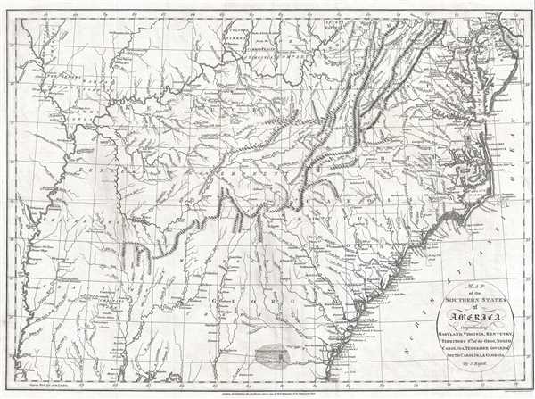
Map of the Southern States of America, Comprehending Maryland, Virginia, Kentucky, Territory South of the Ohio, North Carolina, Tennessee Government, South Carolina, and Georgia.
1795 (dated) 15 x 20 in (38.1 x 50.8 cm) 1 : 3000000
1795 (dated) 15 x 20 in (38.1 x 50.8 cm) 1 : 3000000
Description
This is a 1795 John Russell map of the southeastern United States. The map depicts the region from the Mississippi River to the Atlantic Ocean and from Wilmington, Delaware to Mobile and Mobile Bay, Alabama and Pensacola, Florida.
Expansion of the United States
In capturing the United States' continued push westward, Russell's work identifies important aspects of this movement. Several land companies are identified here, including the Ohio Company, the Illinois Company, and the Wabash Company. These companies were created to help settle land west of the Appalachian Mountains. Some, like the Ohio Company, were legitimate enterprises supported by either a state or the federal government, or both, whose claims were recognized. Others, such as the Illinois-Wabash Company (labeled separately here as both the Illinois Company and the Wabash Company), never achieved legitimacy and their land purchases from the Native Americans were not recognized by a state government (Virginia) or the federal government. The Seven Ranges are also labeled. This tract of land played an important role in the settlement of the American West because it was the first tract surveyed in what became the Public Land Survey System, a system that was used to survey all the land to the west of the Seven Ranges. The Tennessee Government is also labeled, which preceded Tennessee's statehood, which would come later in 1795.
A Closer Look at the Map Itself
An incredibly detailed piece, numerous cities and towns are labeled throughout the region, including Wilmington, Washington, D.C., Annapolis, Richmond, New Berne, Norfolk, Charleston, and Savannah. Other labeled locations include Native American villages throughout the western portion of the map, with tribes such as the Chickasaw and Choctaw being identified on the map. Forts are illustrated and labeled throughout, along with myriad rivers, lakes, and other physical features. Both Albemarle and Pamlico Sound in North Carolina are labeled, along with Delaware Bay and Chesapeake Bay, which is illustrated in detail. The Appalachian Mountains, Allegany Mountains, and Blue Mountains are also illustrated.
This map was drawn by John Russell and published by Henry Delahoy Symonds in 1795.
CartographerS
John Russell (c. 1750 - 1829) was a British cartographer active in London during the late 18th and early 19th centuries. Russell apprenticed as a goldsmith under William Palmer before turning to engraving and printing. He drew maps and engraved for several major publishers of his period including Alexander Dalrymple, Benjamin Henry, Robert Sayer, John Moore, and William Guthrie. Russell's 10 apprentices included such prominent cartographers as Alexander Findlay and Samuel Clapp. Russell was based on Constitution Row Grays Inn Lane, Middlesex (London). More by this mapmaker...
Henry Delahoy Symonds (fl. 1791 - 1816) was a British publisher / printer. He was an active and considerable bookseller for many years in Paternoster Row. As stated in an obituary, 'in the commencement of the crusade against the French Revolution, he suffered four years imprisonment in Newgate, and paid a heavy fine for vending some political pamphlets.' Learn More...
Condition
Very good. Even overall toning. Blank in verso.
References
OCLC 21244894.