This item has been sold, but you can get on the Waitlist to be notified if another example becomes available, or purchase a digital scan.
1741 Covens and Mortier Map of the Southern Hemisphere ( South Pole, Antarctic)
SouthPole-covensmortier-1741$750.00

Title
L'Hemisphere Meridional pour voir plus distinctement Les Terres Australes.
c. 1741 (dated 1739) 19 x 21 in (48.26 x 53.34 cm)
c. 1741 (dated 1739) 19 x 21 in (48.26 x 53.34 cm)
Description
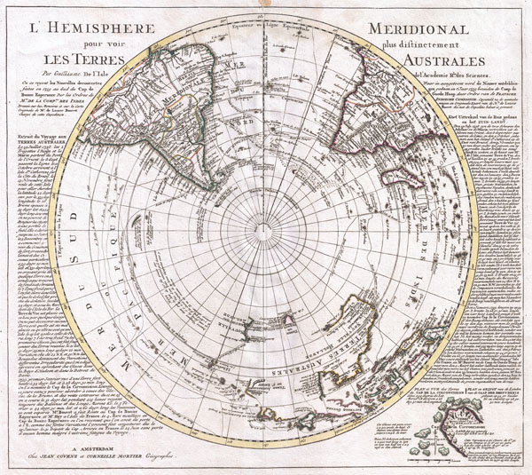
This is a stunning map of the Southern Hemisphere originally drawn by Guillaume de L'Isle and updated in 1739 by Covens and Mortier. Extends from the South Pole northwards in all directions as far as the Equator, encompassing in the process most of South America, southern Africa, Australia, and parts of the East Indies including Borneo, New Guinea, Java and Sumatra. Details the routes taken by numerous explorers including Magellan, Vespucci, Mendana, Dampier, L'Aigle, S. Louis, Halley, Quiros, Maire, Tasman, Davis and others.
Many of the updates to this map over earlier versions focus on the explorations of Lozier de Bouvet. An account of Bouvet's explorations appears on both sides of the map proper - in French on the left and in Dutch on the right. Bouvet explored the Antarctic seas in the late 1730s. In January of 1739 Bouvet discovered an iceberg ridden sea and sighted an outcropping of land he called Cap de la Circoncision. Based upon Bouvet's calculations this would have been the southernmost point of land ever sighted.
At the time, and for roughly 100 years previous, geographers had speculated on the existence of a Southern Continent. The idea of such a continent was based on a theory of balance. Geographers theorized that the weight of Asia had to be counter balanced by a similarly massive continent in the extreme South. The great proponent of this theory in the 18th century was Geographer to the King and Académie des Sciences member Philippe Buache de la Neuville.
Bauche was the preeminent geographical theorist of his day and used Lozier's discoveries to promote his own ideas of a Southern Continent. Thus, returning to our map, we see evidence of Bauchian Antarctic theory in the inset detail of Cap de la Circoncision in the lower right quadrant. Bauche would later theorize that the Cap was actually attached to a great continent further south and that it was the outlet for a large Antarctic Sea.
After Lozier de Bouvet, subsequent explorers had a great deal of difficulty finding Cap de la Circoncision. In the late 18th century Captain Cook searched for the Cap extensively on both his first and second voyages. One of Cook's associates, Captain Furneaux also searched the area with little success. The issue seems to have been a miscalculation by Bouvet regarding Longitude (a typical problem at the time) that placed the island about 23 degrees too far east. The land was finally rediscovered by Captain James Lindsay in 1808 who realized that it was in fact an island and not attached to a greater southern landmass. It was sighted again by the American whaling Captain Benjamin Morrell in 1822 who renamed it Bouvet's Island in honor of its original discoverer.
On to other parts of the map. De L'Isle, based on only the sketchiest knowledge of the region obtained from the voyages of Abel Janszoon Tasman around Australia, maps Australia, or in this case Terres Australes, as attached to both Tasmania (Van Diemen's Land) and New Guinea. Despite this, the western parts of Australia are drawn with relative accuracy while the eastern portions are postulated with a dotted line.
South America, roughly three quarters of which appears here, is well mapped along its shores though speculatively in the interior. Our map shows the Laguna de los Xarayes and the lands of the Xarayes, a corruption of 'Xaraiés' meaning 'Masters of the River.' The Xaraiés were an indigenous people occupying what are today parts of Brazil's Matte Grosso and the Pantanal. When Spanish and Portuguese explorers first navigated up the Paraguay River, as always in search of El Dorado, they encountered the vast Pantanal flood plain at the height of its annual inundation. Understandably misinterpreting the flood plain as a gigantic inland sea, they named it after the local inhabitants, the Xaraies. The Laguna de los Xarayes almost immediately began to appear on early maps of the region and, at the same time, almost immediately took on a legendary aspect as the gateway to El Dorado.
Africa, as was common in the 18th century is full of speculative details regarding the mountains, rivers systems, and indigenous peoples of the interior.
Published by Covens and Mortier in their c. 1741 reissue of Guillaume de L'Isle's Atlas Nouveau...
CartographerS
Covens and Mortier (1721 - c. 1862) was an Amsterdam publishing firm, the successor to the extensive publishing empire built by Pierre Mortier (1661 - 1711). Covens and Mortier maps are often criticized as derivative - but this is not fully the case. Pierre Mortier lived in Paris from 1681 to 1685. There he established close relationships the the greatest French cartographers of the era, including De L'Isle and D'Anville. His business model was based upon leveraging Dutch printing technology and sophistication to co-publish state of the art French cartography. Upon Mortier's death in 1711 his firm was taken over by his son, Cornelius Mortier (1699 - 1783). Cornelius married the sister of Johannes Covens (1697 - 1774) in 1721 and, partnering with his brother in law, established the Covens and Mortier firm. Under the Covens and Mortier imprint, Cornelius and Johannes continued in Pierre's model of publishing the most up-to-date French works with permission. They quickly became one of the largest and most prolific Dutch publishing concerns of the 18th century. The firm and its successors published thousands of maps over a 120 year period from 1721 to the mid-1800s. During their long lifespan the Covens and Mortier firm published as Covens and Mortier (1721 - 1778), J. Covens and Son (1778 - 94) and Mortier, Covens and Son (1794 - c. 1862). More by this mapmaker...
The De L'Isle family (fl. c. 1700 - c. 1760) (also written Delisle) were, in composite, a mapmaking tour de force who redefined early 18th century European cartography. Claude De L'Isle (1644 -1720), the family patriarch, was Paris based a historian and geographer under Nicholas Sanson. De L'Isle and his sons were proponents of the school of "positive geography" and were definitive figures, defining the heights of the Golden Age of French Cartography. Of his twelve sons, four, Guillaume (1675 - 1726), Simon Claude (1675 - 1726), Joseph Nicholas (1688 - 1768) and Louis (1720 - 1745), made a significant contributions to cartography. Without a doubt Guillaume was the most remarkable member of the family. It is said that Guillaume's skill as a cartographer was so prodigious that he drew his first map at just nine years of age. He was tutored by J. D. Cassini in astronomy, science, mathematics and cartography. By applying these diverse disciplines to the vast stores of information provided by 18th century navigators, Guillaume created the technique that came to be known as "scientific cartography", essentially an extension of Sanson's "positive geography". This revolutionary approach transformed the field of cartography and created a more accurate picture of the world. Among Guillaume's many firsts are the first naming of Texas, the first correct map of the Mississippi, the final rejection of the insular California fallacy, and the first identification of the correct longitudes of America. Stylistically De L'Isle also initiated important changes to the medium, eschewing the flamboyant Dutch style of the previous century in favor of a highly detailed yet still decorative approach that yielded map both beautiful and informative. Guillaume was elected to the French Academie Royale des Sciences at 27. Later, in 1718, he was also appointed "Premier Geographe du Roi", an office created especially for him. De L'Isle personally financed the publication of most of his maps, hoping to make heavy royalties on their sales. Unfortunately he met an untimely death in 1728, leaving considerable debt and an impoverished child and widow. De L'Isle's publishing firm was taken over by his assistant, Phillipe Buache who became, posthumously, his son in law. The other De L'Isle brothers, Joseph Nicholas and Louis De L'Isle, were employed in the Service of Peter the Great of Russia as astronomers and surveyors. They are responsible for cataloguing and compiling the data obtained from Russian expeditions in the Pacific and along the northwest coast of America, including the seminal explorations of Vitus Bering and Aleksei Chirikov. The De L'Isles, like their rivals the Vaugondys , must be considered speculative geographers. Speculative geography was a genre of mapmaking that evolved in Europe, particularly Paris, in the middle to late 18th century. Cartographers in this genre would fill in unknown areas on their maps with speculations based upon their vast knowledge of cartography, personal geographical theories, and often dubious primary source material gathered by explorers and navigators. This approach, which attempted to use the known to validate the unknown, naturally engendered many rivalries. The era of speculatively cartography effectively ended with the late 18th century explorations of Captain Cook, Jean Francois de Galaup de La Perouse, and George Vancouver. Learn More...
Source
Covens, J. & Mortier, C., Atlas nouveau, contenant toutes les parties su Monde, ou sont exactement remarquees les empires, monarchies, royaumes, etats, republiques, &c. Par Guillaume de l'Isle, c. 1841 editon.
Condition
Very good condition. Original centerfold. Minor centerfold split and discoloration in margins outside printed area.
References
Rumsey 4638.003. Newberry Library, Ayer 135 .L695 1741 v. 1, pl. [3]. Phillips (Atlases), 595 no.3, 596 no.3. Koeman, C., Atlantes Neerlandici v.2, p.56 (C & M 8 [no.] 3).