This item has been sold, but you can get on the Waitlist to be notified if another example becomes available, or purchase a digital scan.
1900 Amundsen Map of Sichuan and Yunnan Provinces, China
SouthWesternChina-amundsen-1900$100.00

Title
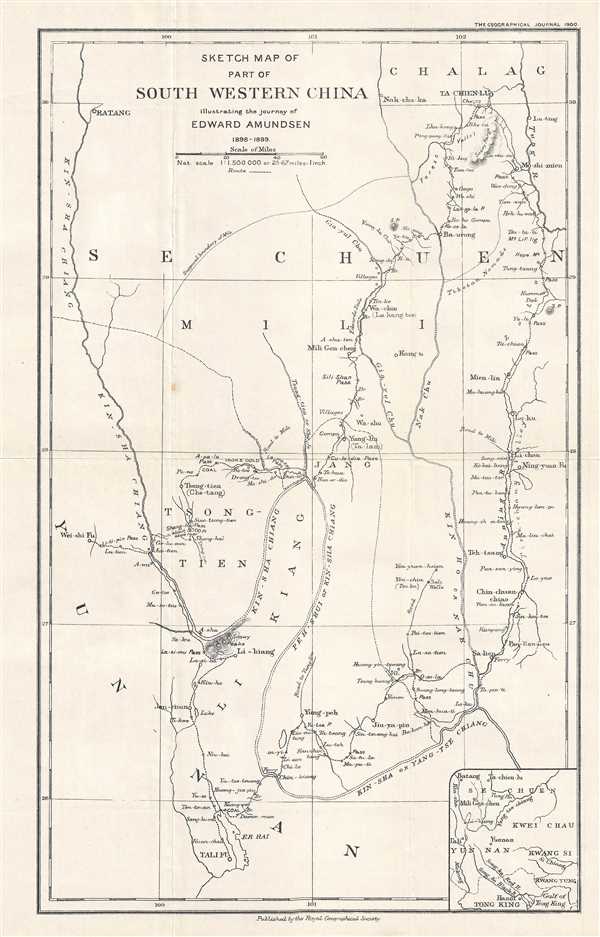
Sketch Map of Part of South Western China illustrating the journey of Edward Amundsen 1898 - 1899.
1900 (dated) 15.5 x 9.75 in (39.37 x 24.765 cm) 1 : 1500000
1900 (dated) 15.5 x 9.75 in (39.37 x 24.765 cm) 1 : 1500000
Description
This is a 1900 Edward Amundsen map of the Sichuan and Yunnan Provinces in China. The map depicts the region from Batang and Ta-Chien-Lu to Dali City (Tali Fu). Illustrating Amundsen's excursion through this territory, a dashed line traces his journey from Wei-shi Fu to Tali Fu (Dali City). Numerous locations along his route are labeled, such as mountain passes, villages, and towns. Rivers, including the Yangtze, snake their way across the map. Amundsen notes forests, iron and gold deposits, and the territory of Tibetan nomads. An inset map situated in the lower right corner gives the viewer a larger regional context, placing Batang and Tali in relation to Yunnan, Hanoi, and the Gulf of Tonkin.
This map was drawn by Edward Amundsen and published in the Geographical Journal by the Royal Geographical Society in 1900.
This map was drawn by Edward Amundsen and published in the Geographical Journal by the Royal Geographical Society in 1900.
CartographerS
Edvard Amundsen (January 27, 1873 - December 21, 1928) was a Norwegian explorer and Lutheran missionary in China and Tibet. He is also known as a Tibetan specialist. Amundsen traveled with Theo Sørensen to Darjeeling and Kalimpong in 1896 as a missionary for the Chinal Inland Mission, where he studied Tibetan religion and customs. After completing his language studies, he parted ways with Sørensen and traveled on to Lhasa. At some later point, Amundsen and Sørensen traveled together to Dartsedo in the foothills of the Tibetan plateau. In 1900, during the Boxer Rebellion, Amundsen was forced to leave China for Darjeeling, but he returned in 1903 and worked in Yunnan or the British and Foreign Bible Society until 1911. He served in China for the last time from 1918/1919 until 1924 for the Mission Covenant Church of Norway. More by this mapmaker...
Royal Geographical Society (fl. 1830 - present) is a British Society established in 1830 to promote geographical science and exploration. Originally titled the "Geographical Society of London", the RGS received its royal charter from Queen Victoria in 1859 shortly after absorbing several similar but more regional societies including the African Association, the Raleigh Club and the Palestine Association. The RGS sponsored many of the most important and exciting voyages of exploration ever undertaken, including the exploration of Charles Darwin, David Livingstone, Robert Falcon Scott, Richard F. Burton, John Speke, George Hayward, H. M Stanley, Ernest Shackleton and Sir Edmond Hillary. Today, the RGS remains a leading global sponsor of geographical and scientific studies. The Society is based in Lowther Lodge, South Kensington, London. Learn More...
Source
The Geographical Journal Vol. XVI, No. 5, November 1900.
Condition
Very good. Even overall toning. Light wear along original fold lines. Blank on verso.
References
OCLC 863580244.