1708 Senex Map of Spain and Portugal
Spain-senex-1763$850.00
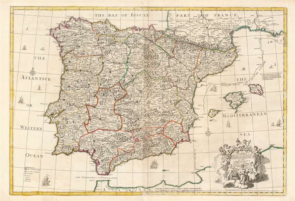

Title
A Correct Map of Spain and Portugal According to the newest observations and discoveries comunicated to the Royal Society at London and the Royal Academy at Paris.
1763 (undated) 24.75 x 36.5 in (62.865 x 92.71 cm) 1 : 1666667
1763 (undated) 24.75 x 36.5 in (62.865 x 92.71 cm) 1 : 1666667
Description
This beautiful, large engraving is John Senex’s 1708 map of Spain and Portugal, covering the entire Iberian Peninsula, including the south of France, part of the north coast of Africa, the Strait of Gibraltar and the Balearic Islands of Ibiza, Majorca, and Minorca. It is attractively engraved, with decorative sailing ships and a baroque-inspired cartouche featuring a half-dozen putti wearing the classical iconography of the Greco-Roman gods (with a martial Mars front-and-center, and a commercial Mercury at top.)
A Correct Map - Fixing Errors
This map - as well as Senex's companion map of France - was intended to correct deficiencies in the maps, specifically, of Nicolas Sanson, which were of such authority that English atlas makers had been content to copy them outright throughout the latter part of the 17th century (and those of the Dutch, generally, which English mapmakers copied faithfully prior to that). In the case of this map, Senex's placement of the Mediterranean coast falls significantly to the west of that proposed by Sanson, whose error Senex emphasizes by illustrating the French geographer's coastline in comparison with his own.'According to the newest observations'
Senex's map is one of the last to show Gibraltar as a Spanish possession, in spite of its having been captured by the British in 1704 during the wars of succession. Gibraltar was made a British colony under the treaty of Utrecht in 1713.Publication History and Census
This map was drawn and engraved by John Senex in 1708. It was initially a separate issue map, but was afterwards included in editions of his English Atlas and later in his New General Atlas. This state, dated 1763, bears the imprint of 'Thomas and John Bowles' who acquired the plate and added it to Robert Sayers' Universal Geographer, which was essentially a repackaging of Senex's plates. The separate map is cataloged only seven times in OCLC, with this 1763 imprint only listed at the National Library of Wales.John Senex (1678 - 1740) was an English engraver and map maker active in London during the first half of the 18th century. Senex was born to upper middle class parents in Shropshire, England. As a young man, he was apprenticed to Robert Clavell, a London bookseller and member of the Stationers' Company, under whom he mastered the arts of engraving and printmaking. Around 1702 Senex completed his apprenticeship and established himself as a printer and bookseller in the Strand. A year later Senex partnered with Jeremiah Seller and Charles Price, the successors to the important mapmaker John Seller, and relocated to Cornhill. This was likely Senex's first introduction to mapmaking though he seems to have taken to it with abandon. In the subsequent years Senex established himself as one of the most prominent cartographers in London, publishing a number of beautiful and important maps that today rank among the finest examples from the Golden Age of British Cartography. In addition to a large corpus of flat maps, Senex also produced a number of important and highly desirable globes. Eventually Senex dissolved his partnership with Seller and Price and relocated to Fleet Street, where he maintained offices until his death in 1740. Senex was succeeded by his widow, Mary Senex, who continued to publish and update his works until about 1755, when the remaining globe and map plates were sold to James Ferguson. Learn More...
The Bowles Family (fl. c. 1714 - 1832) were publishers and map sellers active in London from c. 1714 to c. 1832. The firm, under Thomas Bowles (fl. 1714 - 1763), John Bowles (1701 - 1779), Carrington Bowles (1724 - 1793), and as Bowles and Carver (fl. 1794 - 1832), produced a massive corpus of work that included numerous atlases, pocket maps, and wall maps. The Bowles publishing tradition was kept alive for four generations, starting with Thomas Bowles, a print engraver active in the late 17th century. His son, Thomas Bowles II, produced the firm's first maps at St. Paul's Churchyard, London. Thomas's brother, John Bowles (a.k.a. 'Old John Bowles' or 'Black Horse Bowles'), was also an active publisher established at no. 13 Cornhill. He is credited as one of the first publishers of William Hogarth's works. There, John's son, Carrington Bowles, was introduced to the trade. Carrington took over the Cornhill bookshop and eventually merged it with his uncle's shop in St. Paul's Churchyard. On Carrington's 1793 death, the business was passed to his son Henry Carrington Bowles (1763 - 1830), who partnered with his father's former apprentice Samuel Carver (1756 - 1841), renaming the firm 'Bowles and Carver'. Under this imprint, the firm continued to publish maps and atlases until 1832. Henry Carrington Bowles died in 1830, but Samuel Carver, himself in advanced years and poor health, kept it going for another 2 years before closing the business. Learn More...
Robert Sayer (1725 - January 29, 1794) was an important English map publisher and engraver active from the mid to late 18th century. Sayer was born in Sunderland, England, in 1725. He may have clerked as a young man with the Bank of England, but this is unclear. His brother, James Sayer, married Mary Overton, daughter-in-law of John Overton and widow of Philip Overton. Sayer initially worked under Mary Overton, but by December of 1748 was managing the Overton enterprise and gradually took it over, transitioning the plates to his own name. When Thomas Jefferys went bankrupt in 1766, Sayer offered financial assistance to help him stay in business and, in this way, acquired rights to many of the important Jefferys map plates as well as his unpublished research. From about 1774, he began publishing with his apprentice, John Bennett (fl. 1770 - 1784), as Sayer and Bennett, but the partnership was not formalized until 1777. Bennett retired in 1784 following a mental collapse and the imprint reverted to Robert Sayer. From 1790, Sayer added Robert Laurie and James Whittle to his enterprise, renaming the firm Robert Sayer and Company. Ultimately, Laurie and Whittle partnered to take over his firm. Sayer retired to Bath, where, after a long illness, he died. During most of his career, Sayer was based at 53 Fleet Street, London. His work is particularly significant for its publication of many British maps relating to the American Revolutionary War. Unlike many map makers of his generation, Sayer was a good businessman and left a personal fortune and great estate to his son, James Sayer, who never worked in the publishing business. Learn More...
Source
Sayer, R. Universal Geographer London, 1763.
Condition
Excellent condition. Minor centerfold wear. Two sheets joined as issued. Original outline color.
References
OCLC 1118104107.