This item has been sold, but you can get on the Waitlist to be notified if another example becomes available, or purchase a digital scan.
1560 Zenoni, 'La Freri School' Map of Spain
Spain-zenoi-1560$6,250.00

Title
Hispania Descriptio / Hispania, quae et Iberia in ulteriore dividit ac citeriorem...
1560 (undated) 17.5 x 22 in (44.45 x 55.88 cm) 1 : 2645000
1560 (undated) 17.5 x 22 in (44.45 x 55.88 cm) 1 : 2645000
Description
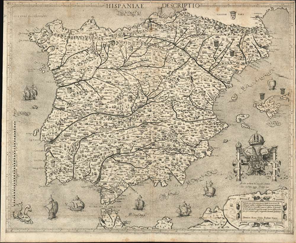
This is a beautiful, rare map of Spain engraved in 1560 by Domenico Zenoni (Zenoi.) It is among the earliest acquirable detailed maps of Spain based on contemporaneous knowledge. It is, moreover, a superb example of the heights the engraver's art reached in 16th century Venice. The oceans are lightly stippled, allowing for its calligraphy to be clearly legible throughout. Cities and mountain regions are shown pictorially. Each of the subordinate realms of Spain are given their respective armorial crests, and the seas are sailed by eight beautifully realized ships, and menaced by three monsters - one of which resembles nothing so much as a dog.
This map, of which we have identified only one state, appears to have been copied closely by Zenoni from the map of the same title engraved by Vincenzo Luchini in Rome in 1559 (which in turn was copied from the 1553 Cock map.) Zenoni follows Luchini closely enough for us to discount the possibility of his having copied the Cock directly, and Zenoni's own use of the word 'Restituit' rather than 'Sculpsit' or 'Excidebat' in his imprint tends to support Zenoni's role here as a copyist. Zenoni's work compares extremely favorably with the Luchini: its engraving clearer, bolder and more legible throughout, and with more distinctive use of dotted lines to illustrate the borders between Spain's realms.
The Modern Mapping of Spain
Late 15th and early 16th century maps of Spain were characterized by blending crude, even Ptolemaic topography with modern toponomy. The maps of Berlingheri, Germanus, Waldseemuller Fries and Münster are examples. The modern mapping of Spain can be said to have begun in earnest with the unacquirable 1532 G. A. Vavassore Nova Descriptio Hispaniae (one copy at Harvard, a photographic copy in the British Library). This woodcut (likely derived from the work of Vincentus Corsulensis, who would receive a credit from Ortelius forty years later) provided the basis for copperplate engravings that would dominate the middle of the 16th century's mapping of the Iberian Peninsula. Although Gastaldi would produce a four-sheet map of Spain in 1544, most other Italian mapmakers did not copy it, choosing instead to reach back to the Corsulensis model via the superb (also unacquirable) 1553 Hieronomus Cock Nova Descriptio Hispaniae. It is in that lineage that the present Zenoni map appears.This map, of which we have identified only one state, appears to have been copied closely by Zenoni from the map of the same title engraved by Vincenzo Luchini in Rome in 1559 (which in turn was copied from the 1553 Cock map.) Zenoni follows Luchini closely enough for us to discount the possibility of his having copied the Cock directly, and Zenoni's own use of the word 'Restituit' rather than 'Sculpsit' or 'Excidebat' in his imprint tends to support Zenoni's role here as a copyist. Zenoni's work compares extremely favorably with the Luchini: its engraving clearer, bolder and more legible throughout, and with more distinctive use of dotted lines to illustrate the borders between Spain's realms.
Maps of the 'Lafreri' School
Between 1544 and the 1580s, Rome and Venice saw the production of a number of elegant, rare, and consequently now sought-after maps. These are frequently classified collectively as belonging to the 'Lafreri-School,' a term often used due to the survival of a 1572 catalogue of maps from the stock of publisher Antonio Lafreri. The close resemblance of this list to the contents of various bound collections of Roman and Venetian maps of the period led to these proto-atlases to be attributed to Lafreri, despite the maps having been actually produced by over a dozen different mapmakers, including Gastaldi, Lafreri himself, his heir Duchetti, the Bertellis, Camochio, Zenoni, Salamanca, Forlani, Ligorio, Tramezini, Zaltieri and others. These cartographers, mapmakers, engravers, and publishers, some of whom shared formalized partnerships, left behind a legacy of some six or seven hundred maps, all of which are marked by scarcity due to their not having been included in a standard atlas. Although these were generally sold in assembled-to-order, composite 'atlases,' the contents varied wildly and those that survive are often poorly catalogued. Since the maps in these composite works were not intended to be compatible with one another, bookbinders had to go to sometimes extreme lengths to combine them: pasting smaller maps down to larger sheets which were then stitched into the books, larger maps trimmed close and then folded to fit smaller bindings. We have also encountered some maps, usually found separately, yet printed to the same sheets to be included together in bound works. The popularity of these works, and their utility, appear to have influenced Ortelius in his project of creating the first true, uniform atlas in 1570. Despite the proliferation of Italian mapmakers in the 1560s and 70s, only a few appear to have lived beyond the Italian plagues of 1575-77, and these survivors seem to have prospered mainly by their acquisition of plates engraved prior to those plagues. The absence of any Italian response to Ortelius' work is more likely to have been more a product of the devastation wrought by the pestilence than any overwhelming superiority of the Flemish work.Publication History and Census
This map is extremely rare, due to its having been separately issued for inclusion in made-to-order Venetian atlases. We see only six examples catalogued in OCLC, at the Bibliotheque Nationale, Bayerische Staatsbibliothek, Studienbibliothek Dillingen, Universitatsbibliothek Tuebingen, Universiteit Leiden and the British Library.Cartographer
Server Error
404
Page Not Found
This page either doesn't exist, or it moved somewhere else.
That's what you can do
Condition
Very good. Printed on joined sheets, with margins extended as issued. Some slight staining, else a beautiful example with a magnificent, sharp strike.
References
OCLC 495039327. Bagrow, Leo History of Cartography, 1985 2nd edition. Baynton-Williams, Ashley The 'LaFreri-School' of Italian Mapmakers Circa 1544-1692 in Mapforum (online resource.) Almagià, Roberto. 'The First 'Modern' Map of Spain.' Imago Mundi 5 (1948): 27-31.