
1850 Norie Nautical Chart of the Western Mediterranean, Balearic Islands

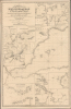

A General Chart of the Mediterranean, Adriatic and Black Seas together with the Grecian Archipelago... [First Sheet].
Bedrock of the British Empire.
- Digital Map Information
- Suitable for large format printing
- File Size: 59.98 MB
- File Type: ZIP / TIFF
- ICC color profile embedded
- Delivered instantly via download link
Bedrock of the British Empire.
This is John Norie's large-format 1850 nautical chart of the western Mediterranean Sea, including the Strait of Gibraltar and the Balearic Islands. Among other features, it highlights the critically important Strait of Gibraltar, the crux of British naval power in the Mediterranean.A Closer Look
The chart covers the western Mediterranean from Cadiz, Tangier, and the Strait of Gibraltar in the west to Nice and the Gulf of Stora (Skikda) in Algeria in the east. Cities and towns, river estuaries, mountains, capes, bays, and other features are labeled all along the coastlines of islands and the mainland of Europe and Africa. Soundings, hazards, bottoms, banks, shoals, reefs, rocks, islets, anchorages, currents, and other essential navigational information are also noted. Crossed swords indicate the location of the 1805 Battle of Trafalgar.Eighteen insets surround the map, with additional navigational information on ports and important waterways, including the Strait of Gibraltar. The insets have extensive notes on the number and nature of lights, with lighthouses illustrated where applicable. Some of the insets cover ports not on the chart, as this chart was originally the westernmost and title sheet of a larger multi-sheet work covering the entire Mediterranean. For example, insets are included for Leghorn (Livorno) and Genoa, with the latter illustrating the Genoa Lighthouse (Lanterna di Genova), the tallest in the world from its construction in 1543 until the early 20th century
Bedrock of the British Empire
Aside from India, perhaps no single piece of land played a greater role in the history of the British Empire than the 2.6 square miile territory of Gibraltar at the southern tip of Iberia. The stronghold, situated on a peninsula dominated by a limestone mountain (the Rock of Gibraltar), was captured by the British in 1704 during the War of Spanish Succession (1701 - 1714) and was granted to them in the 1713 Treaty of Utrecht that ended that conflict; it has remained a territory of Great Britain ever since. Spain was naturally not thrilled about the prospect of a hostile power controlling a stronghold adjacent to their own territory, especially one that effectively controlled access to the Mediterranean, and besieged Gibraltar in 1727 and for more than three and a half years during the American Revolutionary War (1775 - 1783). However, the British could not be dislodged. Subsequently, the territory played a critical role as a base for the Royal Navy during the Napoleonic Wars (1803 - 1815), including the period leading up to the Battle of Trafalgar. The British continued to fortify and upgrade facilities at Gibraltar throughout the 19th century. It became the keystone in a string of bases throughout the Mediterranean that would eventually protect the vital link to India once the Suez Canal was opened in 1869.Blueback Charts
Blueback nautical charts began appearing in London in the late 18th century. Bluebacks, as they came to be called, were privately published large-format nautical charts known for their distinctive blue paper backing. The backing, a commonly available blue manila paper traditionally used by publishers to wrap unbound pamphlets, was adopted as a practical way to reinforce the low-quality paper used by private chart publishers in an effort to cut costs. That being said, not all blueback charts are literally backed with blue paper. The earliest known blueback charts include a 1760 chart issued by Mount and Page, and a 1787 chart issued by Robert Sayer.The tradition took off in the early 19th century, when British publishers like John Hamilton Moore, Robert Blachford, James Imray, William Heather, John William Norie, Charles Wilson, David Steel, R. H. Laurie, and John Hobbs, among others, rose to dominate the chart trade. Bluebacks became so popular that the convention was embraced by chartmakers outside of England, including Americans Edmund March Blunt and George Eldridge, as well as Scandinavian, French, German, Russian, and Spanish chartmakers. Blueback charts remained popular until the late 19th century, when government-subsidized organizations, such as the British Admiralty Hydrographic Office and the United States Coast Survey, began issuing their own superior charts on high-quality paper that did not require reinforcement.
Publication History and Census
This chart was originally prepared by John Norie in 1830, based on his earlier 'A chart of the Mediterranean Sea' with William Heather, and then updated several times, often with slight changes in the title, until the present edition in 1850. Although here as a stand-alone, this map could also have been combined with other charts in a massive single-scale multi-sheet set covering the entire Mediterranean Sea, titled, in this edition, A Chart of the Mediterranean, the Adriatic or Gulf of Venice, the Black Sea, Grecian Archipelago, and the Seas of Marmara and Azof. An additional complicating factor is that, no doubt due to insatiable demand, Norie issued multiple single and multi-sheet charts of the Mediterranean of different sizes and with narrower or wider coverage as customers might deem suitable. All of these are rare today. We have not located any examples of the present edition in institutional collections, while the British Library holds an 1854 edition and the National Library of Wales holds a 1855 edition.Cartographer
John William Norie (June 3, 1772 - December 24, 1843) was a British teacher of navigation, hydrographer, chart maker, and publisher of maritime manuals active in London, England in the late 18th and early 19th centuries. Norie was born in Wapping, London, an area long associated with the maritime sciences. Norie's career as a chart maker commenced under the tutelage of William Heather, a prominent purveyor and publisher of nautical charts, pilot books, and navigational tools who took over the firm of Mount and Page in 1765. Heather and Norie were likely acquainted through John Hamilton Moore, another important chart maker with whom both seem to have been associated early in their careers. Heather hired Norie to teach basic navigation at his shop at 157 Leadenhall Street. Under Heather Norie also distinguished himself as a draftsman, completing many of the early charts associated with the Heather firm. When Heather died in 1812 John Norie partnered with George Wilson, a moneyed 'man about town' with little experience in the maritime trades, to acquire the map and chart business at 9500 British Pounds. It proved a good deal for Norie, who retained all copyright privileges and drew 1/4 quarter share of business profits, as well an impressive quarterly salary and, for doing all of the work, 1/3rd of Wilson's share. The firm, referred to as the 'Naval Warehouse' quickly acquired a reputation for quality navigational materials and became a favorite of merchant seamen. It was even referenced in Charles Dickens' classic novel Dombey and Son. In 1819, Norie and Wilson acquired the failing chart business of David Steel, which significantly increased the size, though not quality, of their chart catalogue. With the rise of the British Admiralty and its own maritime chart productions, the business of "Chart Purveyor" in London dramatically changed. Admiralty charts and pilot books, designed for military use, were offered through established intermediaries, like Norie, at bargain prices. Most chart makers of the period found it profitable to use the highly technical Admiralty charts to update their own more decorative vernacular charts. For a brief time this practice proved exceptionally profitable but eventually began to draw criticism. Nonetheless, Norie retired to Edinburgh in 1840 and died a wealthy man in 1843. In 1840 the business passed to a nephew of George Wilson, Charles Wilson, who renamed the firm "Norie & Wilson". William Heather Norie, J. W. Norie's own son, produced few charts, instead pursuing a career in the legal field. Norie & Wilson merged with James Imray's prosperous chart business in 1899, becoming Imray, Laurie, Norie & Wilson, a profitable concern that remains active in the maritime charting industry. Further Details...
Condition
Very good. Slight centerfold toning. Laid down on old linen.