
1964 Dar al-Qalam Arabic Map of Palestine

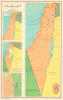
فلسطين / [Palestine].
Water Wars in Palestine.
Water Wars in Palestine.
This is a large-format 1964 Arabic-language map of Israel - Palestine published by Dar al-Qalam in Cairo. Produced during a period of increasing tensions, the map provides context on the background to the 1967 Six-Day War.A Closer Look
This sheet consists of four maps, a main large map at right and three insets at left. The main map at right displays the entirety of Palestine (Israel-Palestine) without internal political divisions, and with roads, railways, cities, regions, and waterways indicated. The middle inset at center-left displays the West Bank, Gaza Strip, and several demilitarized zones, while the inset at bottom-left depicts Jerusalem divided between West and East along the de facto borders predominating between 1949 and 1967.The 'War over Water,' the Six-Day War, and the PLO
The topmost of the insets is the most curious and arguably the most significant, though this is not immediately apparent. It refers to competing major hydraulic engineering projects - the National Water Carrier of Israel (red lines), which diverted waters of the Sea of Galilee and the Jordan River southwards to the Negev to promote Israeli settlement of the region, and an Arab attempt to use the Jordan's waters to similar ends. These rival projects raised tensions in the years before the 1967 Six-Day War. Israel had long contemplated a large-scale water diversion project and had begun construction on it in 1953, but Arab protests resulted in a 1955 U.S.-brokered agreement called the Johnston Plan, which Arab states adhered to but never ratified. When Israel began pumping water from the Sea of Galilee in 1964 (within the bounds of the Johnston Plan), the Arab League again protested, and the Syrian military attempted to use military force to halt the project, to little avail. Instead, the Arab states aimed to divert the headwaters of the Jordan River at the Yarmouk River (black lines). Cross-border clashes around the competing water plans intensified in the following months, and were eventually a major contributing factor to the outbreak of the Six-Day War in June 1967.Concurrently, the Palestine Liberation Organization (PLO) was officially founded in June 1964, and its first organized action was an attack on the National Water Carrier of Israel in January 1965. Initially, the PLO was essentially a pan-Arab organization and operated from bases in Jordan (especially the West Bank), Egypt (especially the Gaza Strip, occupied by Egypt at the time), Lebanon, and Syria. After the Six-Day War, however, greater emphasis was placed on the creation of a Palestinian state (pan-Arab nationalism already being greatly weakened by internal tensions), with less willingness to accept Jews as equal members of a unified Palestinian state (though those residing in Palestine prior to 'the Zionist invasion' would nominally be allowed to stay). Following the Six-Day War, tensions between the PLO and the Jordanian government increased to the point that it resulted in a civil war in Jordan and the expulsion of the PLO to Lebanon.
Publication History and Census
This map was prepared by a group of scholars - Dr. Muhammad Sobhi Abdel Hakim (دكتور محمد صبحي عبد الحكيم), Dr. Yusuf Khalil Yusuf (دكتور يوسف خليل يوسف), and Halim Jirish (حليم جريش) -, printed by Dar Misr Printing House (or Egyptian Printing House, دار مصر للطباعة) and published by Dar al-Qalam (دار القلم, House of the Pen) in Cairo in 1964. We are only aware of one other example of this map in institutional collections, held by the University of Arizona.Cartographer
Dr. Muhammad Sobhi Abdel Hakim (June 4, 1928 - March 3, 2009; دكتور محمد صبحي عبد الحكيم) was an Egyptian geographer, academic administrator, and politician. He was born in the Shubra District of Cairo and studied geography at the University of Cairo, earning a Bachelors (1949), Masters (1953), and PhD (1959) there. He then went on to teach at the same university, rising to the position of Head of the Geography Department in 1971, then the Dean of the Faculty of Arts, and eventually Vice President of the university. Hakim then took on several government positions and from 1980 to 1985 served as the Speaker of the Shura Council, the upper chamber of Egypt's legislature at the time. He published more than a dozen books and many articles over the course of his career, was a leading figure among geographers in the Arab world, and was highly decorated by the Egyptian state for his public service. Further Details...
Condition
Very good.
References
OCLC 892493679.