
This item below is out of stock, but another example (left) is available. To view the available item, click "Details."
Details
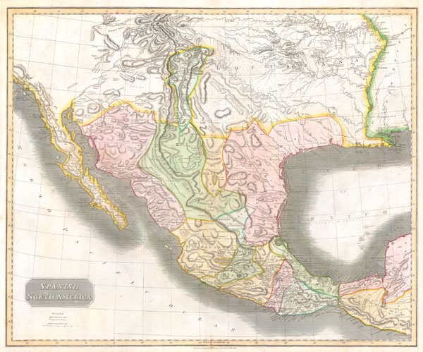
1814 Thomson Map of Mexico and Texas
1814 (dated) $650.00
1814 Thomson Map of Texas, Mexico & Louisiana
SpanishNorthAmer-t-1814$500.00

Title
Spanish North America.
1814 (dated) 20 x 25 in (50.8 x 63.5 cm)
1814 (dated) 20 x 25 in (50.8 x 63.5 cm)
Description
This hand colored map, along with Pinkerton's similar map, is most likely the most important large format English map of the American Southwest to be produced in the 19th century. Depicts Mexico from the Yucatan north to what would become the Republic of Texas, the Louisiana Territory, and what would eventually be the U.S. States of New Mexico, Arizona, Texas, California, Nevada, Utah, Louisiana, Oklahoma and Colorado. This map is based largely on the explorations of Humboldt, Long and Pike. The name Texas appears on this map only as the name of a settlement on the Colorado River. There are curiously two Great Salt lakes and an unknown river connecting them. The Louisiana region is especially well notated with numerous annotations regarding the Indian tribes inhabiting the region. Dated: 'Drawn and Engraved for Thomsons New General Atlas 1814.' This map is an essential addition to any serious Texas, Trans-Mississippi, or Southwest collection
Cartographer
John Thomson (1777 - c. 1841) was a Scottish cartographer, publisher, and bookbinder active in Edinburgh during the early part of the 19th century. Thomson apprenticed under Edinburgh bookbinder Robert Alison. After his apprenticeship, he briefly went into business with Abraham Thomson. Later, the two parted ways, John Thomson segueing into maps and Abraham Thomson taking over the bookbinding portion of the business. Thomson is generally one of the leading publishers in the Edinburgh school of cartography, which flourished from roughly 1800 to 1830. Thomson and his contemporaries (Pinkerton and Cary) redefined European cartography by abandoning typical 18th-century decorative elements such as elaborate title cartouches and fantastic beasts in favor of detail and accuracy. Thomson's principle works include Thomson's New General Atlas, published from 1814 to 1821, the New Classical and Historical Atlas of 1829, and his 1830 Atlas of Scotland. The Atlas of Scotland, a work of groundbreaking detail and dedication, would eventually bankrupt the Thomson firm in 1830, at which time their plates were sequestered by the court. The firm partially recovered in the subsequent year, allowing Thomson to reclaim his printing plates in 1831, but filed again for bankruptcy in 1835, at which time most of his printing plates were sold to A. K. Johnston and Company. There is some suggestion that he continued to work as a bookbinder until 1841. Today, Thomson maps are becoming increasingly rare as they are highly admired for their impressive size, vivid hand coloration, and superb detail. More by this mapmaker...
Condition
Fine or Perfect condition. Wide clean margins. Original platemark visible. Bank on verso.