This item has been sold, but you can get on the Waitlist to be notified if another example becomes available, or purchase a digital scan.
1855 U.S. Coast Survey Map of St. Andrews Bay, Florida
StAndrewsBayFlorida-uscs-1855$75.00

Title
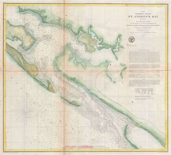
(G No. 4) Preliminary Chart of St. Andrew's Bay Florida.
1855 (dated) 18 x 20 in (45.72 x 50.8 cm)
1855 (dated) 18 x 20 in (45.72 x 50.8 cm)
Description
An uncommon 1855 U.S. Coast Survey map or nautical chart of St. Andrews Bay, Florida. The map identifies St. Andrews City, which would soon evolve into Panama City, the seat of Bay County, Florida. Sailing directions appear in the upper right quadrant below the title. Located on the Panhandle of Florida, this map covers the Bay, which is known for its beautiful beaches. St. Andrews Bay was the site of a vast network of saltworks critical to the Confederacy during the American Civil War. The Union naval officer edward Crissey, in command of the steamboat USS Bloomer took advantage of the shallow draft of the steamboat to sail into the bay where other, deeper draft vessels, were unable to follow. The ensuing destruction of the St. Andrews saltworks did considerable damage to the Confederate War effort. This map was drawn on a scale of 1:40,000. The triangulation is the world of F. H. Gerdes. The Topography was accomplished by G. D. Wise. The Hydrography was completed by a party under the command of G. H. Berryman. The whole was compiled under the exacting direction of A. D. Bache, Superintendent of the Coast Survey.
CartographerS
The Office of the Coast Survey (1807 - present) founded in 1807 by President Thomas Jefferson and Secretary of Commerce Albert Gallatin, is the oldest scientific organization in the U.S. Federal Government. Jefferson created the "Survey of the Coast," as it was then called, in response to a need for accurate navigational charts of the new nation's coasts and harbors. The spirit of the Coast Survey was defined by its first two superintendents. The first superintendent of the Coast Survey was Swiss immigrant and West Point mathematics professor Ferdinand Hassler. Under the direction of Hassler, from 1816 to 1843, the ideological and scientific foundations for the Coast Survey were established. These included using the most advanced techniques and most sophisticated equipment as well as an unstinting attention to detail. Hassler devised a labor intensive triangulation system whereby the entire coast was divided into a series of enormous triangles. These were in turn subdivided into smaller triangulation units that were then individually surveyed. Employing this exacting technique on such a massive scale had never before been attempted. Consequently, Hassler and the Coast Survey under him developed a reputation for uncompromising dedication to the principles of accuracy and excellence. Unfortunately, despite being a masterful surveyor, Hassler was abrasive and politically unpopular, twice losing congressional funding for the Coast Survey. Nonetheless, Hassler led the Coast Survey until his death in 1843, at which time Alexander Dallas Bache, a great-grandson of Benjamin Franklin, took the helm. Bache was fully dedicated to the principles established by Hassler, but proved more politically astute and successfully lobbied Congress to liberally fund the endeavor. Under the leadership of A. D. Bache, the Coast Survey completed its most important work. Moreover, during his long tenure with the Coast Survey, from 1843 to 1865, Bache was a steadfast advocate of American science and navigation and in fact founded the American Academy of Sciences. Bache was succeeded by Benjamin Pierce who ran the Survey from 1867 to 1874. Pierce was in turn succeeded by Carlile Pollock Patterson who was Superintendent from 1874 to 1881. In 1878, under Patterson's superintendence, the U.S. Coast Survey was reorganized as the U.S. Coast and Geodetic Survey (C & GS) to accommodate topographic as well as nautical surveys. Today the Coast Survey is part of the National Oceanic and Atmospheric Administration or NOAA as the National Geodetic Survey. More by this mapmaker...
Alexander Dallas Bache (July 19, 1806 - February 17, 1867) was an American physicist, scientist and surveyor. Bache is best known in cartographic circles as the Superintendent of the U.S. Coast Survey from 1843 to 1865. Born in Philadelphia, Bache, a great grandson of the statesman and inventor Benjamin Franklin, had a varied career primarily focused on education. He toured Europe on behalf of Girard College and composed an important treatise on European Education. Later he served as president of Philadelphia's Central High School and was a professor of natural history and chemistry at the University of Pennsylvania. On the death of Ferdinand Rudolph Hassler, Bache was appointed Superintendent of the United States Coast Survey. Picking up where Hassler left off Bache presided over the Survey during its most prolific period and oversaw the mapping of most of the United States coastline. To this day his name appears on countless marine pilot books and U.S. Coast Survey nautical charts. For his work he was elected Associate Fellow of the American Academy of Arts and Sciences, a Fellow of the Royal Society of Edinburgh, and a Foreign Member of the Royal Society. Following the Civil War, Bache was elected a 3rd Class Companion of the Military Order of the Loyal Legion of the United States. He died at Newport, Rhode Island and was buried in the Congressional Cemetery in Washington, DC, where he is commemorated with a monument built by American architect Henry Hobson Richardson. Learn More...
Ferdinand H. Gerdes (September 15, 1809 - June 27, 1884) was one of the most active members of the U.S. Coast Survey team. His most important work includes several surveys of New York Harbor as well as detailed surveys of Florida, the Gulf Coast, and up the Mississippi River. Gerdes was born in Hanover, Germany (Prussia) and relocated to the United States sometime before 1836, when he joined he fledgling U.S. Coast Survey as an Sub-assistant under Hassler. From 1841 - 1844 he surveyed the New Jersey, Maryland, Delaware Bay Region. In 1844 he was assigned to the Gulf Coast, where he produced his most important and pioneering work. During the American Civil War, like most of the members of the Coast Survey, Gerdes was strongly pro-Union and worked diligently during the Civil War to provide Union commanders accurate surveying and cartographic materials. Gerdes is known to have commanded the ‘Sachem' and, during the Civil War, was heavily engaged with Union efforts to map and ultimately control, the Mississippi River. Following the war he produced detailed surveys of the Passes of the Mississippi. His health and age catching up on him, Gerdes retired to New York, where he completed additional surveys of long island as late as 1883, a year before his death. Learn More...
Source
Report of the Superintendent of the United States Coast Survey, Washington, 1855.
Condition
Good condition. Some toning and verso repair and reinforcement on original fold lines. Some foxing throughout - see image. Blank on verso.