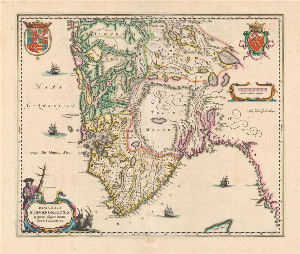
1640 Blaeu Map of the Diocese of Stavanger, Norway
Stavanger-blaeu-1640$750.00

Title
Dioecesis Stavangriensis et partes aliquot vicinae, operâ L. Scavenii, S.S..
1640 (undated) 16.25 x 19.5 in (41.275 x 49.53 cm) 1 : 1000000
1640 (undated) 16.25 x 19.5 in (41.275 x 49.53 cm) 1 : 1000000
Description
This is a beautiful, original color example of Joan and Cornelis Blaeu's 1640 map of the Diocese of Stavanger, Norway - the first of the Blaeu maps to relate to Norway specifically. The map is a lovely example of the Blaeus' work: its geographical delineations clear, its lettering attractive and uniformly legible, and with an array of decorative elements. The waters of the North Sea are sailed by four ships; the coat of arms of Norway is displayed to the upper right while the arms of the kingdom of Denmark appears to the upper left (both countries were at the time ruled by King Christian IV of Denmark). In the lower left, a beautifully engraved title cartouche is flanked by two Norwegian goats, and a woodsman - an allusion to the region's role as exporter of lumber to Europe in general, and the Netherlands specifically.
Source
The map is credited to Laurits Clausen Scabo, (1562-1626) a Danish scholar and priest who from 1605 until his death was Bishop of Stavanger. Scabo, in 1618, is reputed to have drawn up the map of his diocese which informed the present work, although the original has not survived. The map did not reach publication until during the tenure of Scabo's successor Bishop Thomas Wegner (1588 – 1654), and it has been suggested that historian and clergyman Peder Claussøn Friis may have been responsible for the map. Friis' maps, sketches, and notes had passed to Scavenius at Friis' death in 1614, so it is possible that Wegner did not know who produced the work. Friis is not known to have produced any maps, but he and Scabo did know each other, and his historical and topographical descriptions may well have informed Scabo's efforts to map his diocese.Scope of the Map
The map spans from the northern tip of Denmark (Jutiae Pars) to the Sognefjord and includes the southern half of the Diocese of Bergen, as well as Scabo's Diocese of Stavanger. The regions detailed are now the southern part of the Vestland, and the counties of Agder and Rogaland. The inland counties of Telemark and Viken also appear, including the Hallingdal Valley - here marked as the northern extent of the Stavanger Diocese.Adding to the Atlas
This was the first map in Blaeu's atlas, apart from the general map of Scandinavia (derived from the 1626 map of Anders Bure), to focus on Norway specifically. More such would not appear until the inclusion of seven area maps in the 1659 Spanish text Nuevo Atlas.Publication History and Census
This map was engraved by Joan and Cornelis Blaeu for inclusion in the 1640 editions of the Atlas Novus. The present example is from a French edition. We suspect this to be an example printed for inclusion in the 1663 Le Grand Atlas but repaginated for later inclusion in an earlier Nouvel Atlas. The map is, in its various editions, well represented in institutional collections.CartographerS
Joan (Johannes) Blaeu (September 23, 1596 - December 21, 1673) was a Dutch cartographer active in the 17th century. Joan was the son of Willem Janszoon Blaeu, founder of the Blaeu firm. Like his father Willem, Johannes was born in Alkmaar, North Holland. He studied Law, attaining a doctorate, before moving to Amsterdam to join the family mapmaking business. In 1633, Willem arranged for Johannes to take over Hessel Gerritsz's position as the official chartmaker of the Dutch East India Company, although little is known of his work for that organization, which was by contract and oath secretive. What is known is his work supplying the fabulously wealthy VOC with charts was exceedingly profitable. Where other cartographers often fell into financial ruin, the Blaeu firm thrived. It was most likely those profits that allowed the firm to publish the Theatrum Orbis Terrarum, sive, Atlas Novus, their most significant and best-known publication. When Willem Blaeu died in 1638, Johannes, along with his brother Cornelius Blaeu (1616 - 1648) took over the management of the Blaeu firm. In 1662, Joan and Cornelius produced a vastly expanded and updated work, the Atlas Maior, whose handful of editions ranged from 9 to an astonishing 12 volumes. Under the brothers' capable management, the firm continued to prosper until the 1672 Great Amsterdam Fire destroyed their offices and most of their printing plates. Johannes Blaeu, witnessing the destruction of his life's work, died in despondence the following year. He is buried in the Dutch Reformist cemetery of Westerkerk. Johannes Blaeu was survived by his son, also Johannes but commonly called Joan II, who inherited the family's VOC contract, for whom he compiled maps until 1712. More by this mapmaker...
Laurits Clausen Scabo (Lat. Scavenius) (November 1, 1562 - December 1, 1626) was a Danish bishop and professor. He was born and educated in Copenhagen, the son of the professor of mathematics there. It is supposed that he at least knew Tycho Brahe. He traveled a time, returning in 1590 to become principal of the Metropolitan School in Copenhagen, later becoming professor at the University there. During his tenure there, he became parish priest in Tårnby in Amager. In 1605 he was appointed bishop of Stavanger, southern Norway. During his time as bishop he had a land register compiled of all ecclesiastical property in the diocese, beteeen 1620 and 1624. He is credited with having drawn a map, circa 1618, of his bishopric. This was published in 1640 by Blaeu. Learn More...
Source
Blaeu, J., Théâtre du Monde ou Nouvel Atlas, (Amsterdam: Blaeu) 1640.
The classic Dutch atlas, whose publication ushered in the Dutch golden age of cartography. Willem Jansz Blaeu had been, since 1604, producing engraved maps for sale; these were separate issues (and all consequently extremely rare) until the publishing of Blaeu's Appendix in 1630 and 1631, which also included a number of maps purchased from the widow of Jodocus Hondius, (for example his famous iteration of John Smith's map of Virginia.) In 1634, he announced his intention to produce a new world atlas in two volumes, entitled Theatrum Orbis Terrarum, sive Atlas Novus (Théâtre du Monde ou Nouvel Atlas) (in an effort to invoke the successful work of the same title produced by Ortelius the previous century, while reinforcing the notion of it being a new work.) This work was published first in German in 1634, followed by Latin, Dutch and French editions in 1635. Blaeu's maps have always been noted for the quality of their paper, engraving and fine coloring, and this was the intent from the very start. The 1634 announcement of the upcoming work described it: 'All editions on very fine paper, completely renewed with newly engraved copperplates and new, comprehensive descriptions.' (van der Krogt, p,43) Many of the most beautiful and desirable maps available to the modern collector were printed and bound in Blaeu's atlases. Willem's son, Joan, would go on to add further volumes to the Atlas Novus, concurrently printing new editions of the first two volumes with additional maps, in effect making these new editions an entirely new book. Under Joan there would be nine Latin editions, twelve French, at least seven Dutch, and two German. This exceedingly successful work would be the mainstay of the Blaeu firm until 1661, at which point the work was supplanted by Joan Blaeu's masterwork Atlas Maior in 1662.
Condition
Very good. Some offsetting and scuffing to the color of the coats of arms, else excellent with generous margins and a sharp strike.
References
OCLC 921706885. Ginsberg, W. Maps and Mapping of Norway 1602-1855, Bla 1.0. Rumsey 10017.029 (1665). Van der Krogt, P. C. J., Koeman's Atlantes Neerlandici, V. 2, 1310.