1814 Thomson Map of West Indies Islands: St. Christophers, St. Lucia, and Nevis
StChristoperStLucia-thomson-1814-2$300.00

Title
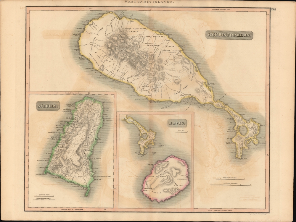
West India Islands. / St. Christoperhs. / St. Lucia. / Nevis.
1814 (undated) 20.5 x 24 in (52.07 x 60.96 cm) 1 : 70000
1814 (undated) 20.5 x 24 in (52.07 x 60.96 cm) 1 : 70000
Description
This is John Thomson's 1814 map of the Caribbean Islands of St. Kitts, St. Lucia, and Nevis. This map was issued in the year St. Lucia was ceded to the British Empire.
A Closer Look
The sheet presents three separate maps: The main map focuses on St. Kitts (St. Christophers). A smaller inset appears at bottom center, expanding coverage of southeast of St. Kitts to include nearby Nevis. A third inset, in the lower right, details St. Lucia. All three focus on costal features, with very little inland detail, likely betraying Thomson's sources as nautical charts. Nonetheless, important churches and topographical elements are noted.St. Kitts and Nevis - Historical Context
In 1814, St. Kitts, also known as Saint Christopher, and nearby Nevis, were key jewels in the British colonial Caribbean crown. Having been contested over by both the British and French across previous centuries, it solidified as a British possession in the 1713 Treaty of Utrecht. The island's economy was anchored in the plantation system, primarily centered around sugar production, which relied heavily on the labor of enslaved Africans. Today, St. Kitts, as part of the federation of St. Kitts and Nevis, is a vibrant Caribbean nation known for its rich history, stunning natural beauty, and diverse cultural heritage. Moving beyond its colonial and sugar-centric past, the island has successfully pivoted towards tourism as a primary economic driver.St. Lucia - Historical Context
In the year this map was issued 1814, St. Lucia was formally and permanently ceded to Great Britain after over a century of changing hands. The island nonetheless bore cultural imprints from both empires. Sugar cane plantations sprawled across its landscapes, underpinned by the labor of enslaved Africans, making it a vital cog in the lucrative West India sugar economy.Publication History and Census
This map was prepared and engraved in 1814 in Edinburgh for inclusion in the 1817 first edition of John Thomson's New General Atlas. It was engraved by Robert Kirkwood and his son, also Robert. The map is well represented in institutions and appears on the market from time to time.CartographerS
John Thomson (1777 - c. 1841) was a Scottish cartographer, publisher, and bookbinder active in Edinburgh during the early part of the 19th century. Thomson apprenticed under Edinburgh bookbinder Robert Alison. After his apprenticeship, he briefly went into business with Abraham Thomson. Later, the two parted ways, John Thomson segueing into maps and Abraham Thomson taking over the bookbinding portion of the business. Thomson is generally one of the leading publishers in the Edinburgh school of cartography, which flourished from roughly 1800 to 1830. Thomson and his contemporaries (Pinkerton and Cary) redefined European cartography by abandoning typical 18th-century decorative elements such as elaborate title cartouches and fantastic beasts in favor of detail and accuracy. Thomson's principle works include Thomson's New General Atlas, published from 1814 to 1821, the New Classical and Historical Atlas of 1829, and his 1830 Atlas of Scotland. The Atlas of Scotland, a work of groundbreaking detail and dedication, would eventually bankrupt the Thomson firm in 1830, at which time their plates were sequestered by the court. The firm partially recovered in the subsequent year, allowing Thomson to reclaim his printing plates in 1831, but filed again for bankruptcy in 1835, at which time most of his printing plates were sold to A. K. Johnston and Company. There is some suggestion that he continued to work as a bookbinder until 1841. Today, Thomson maps are becoming increasingly rare as they are highly admired for their impressive size, vivid hand coloration, and superb detail. More by this mapmaker...
Robert Kirkwood (December 8, 1774 – November 14, 1818) was a Scottish engraver active in Edinburgh during the late 18th and early 19th century. He is the scion of the important Scottish Kirkwood family, who produced a number of great engravers. His father was James Kirkwood, another well-known Edinburgh engraver, and probably the man who trained him in the engraver's art. Initially he patterned with his father and they published under the imprint of 'Kirkwood and Son,' but after about 1814 to his death, he published under his own name. Around 1803 Kirkwood invented and patented a modification to the standard printing press that increased printing speeds. He died at his home, 3 Arniston Place, in Edinburgh. He was survived by his son, also Robert Kirkwood (1798 – 1843) who continued the family engraving enterprise. Learn More...
Source
Thomson, J., A New General Atlas, (Edinburgh: Baldwin, Cradock, Joy) 1817.
Thomson's New General Atlas was first published in 1817 and continued to be published until about 1821. This is the first of Thomson's major cartographic works and the atlas for which is most celebrated. The New General Atlas follows in the Edinburgh School, which eschews excessive decoration in favor of a more minimalistic fact-based cartographic vision, as established by John Pinkerton, Laurie and Whittle, John Cary, and others in the previous decades. The maps are notable for their massive scale, heavy stock, elegant color work, and easy-to-read typefaces. Although the atlas stopped being published after 1821, Thomson continued to offer 'supplementary' maps that could be tipped into the atlas as late as 1830, when he declared bankruptcy. The maps in the Thomson Atlas were engraved by Thomas Clerk, William Dassauville, Nathaniel Rogers Hewitt, James Kirkwood, Robert Kirkwood, John Menzies, George Menzies, Edward Mitchell, John Moffatt, Samuel John Neele, Robert Scott, and James Wyld.
Condition
Very good. Original centerfold exhibits some light toning. Transference. Original platemark visible.
References
Rumsey 1007.070. Phillips (Atlases) 731.