This item has been sold, but you can get on the Waitlist to be notified if another example becomes available, or purchase a digital scan.
1855 Stevens Map of Northern Railroad Routes: Montana, Idaho, Washington
StevensRoute-stevens-1855$425.00

Title
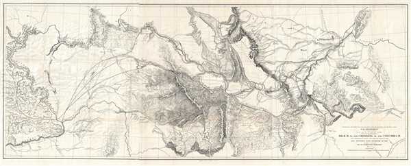
Explorations and Surveys for a Rail Road Route from the Mississippi River to the Pacific Ocean. War Department. Routes near the 47th and 49th Parallels. Milk R. to the Crossing of the Columbia R.
1855 (dated) 25 x 62.5 in (63.5 x 158.75 cm) 1 : 600000
1855 (dated) 25 x 62.5 in (63.5 x 158.75 cm) 1 : 600000
Description
This is an 1855 Isaac I. Stevens map of the explorations to discover a proposed northern route of the transcontinental railroad. Carl I. Wheat considers this map so significant that he illustrates it in full. The map depicts from the Yellowstone River in Wyoming and the northern Missouri River to the Columbia River in Washington and includes large portions of Montana and Idaho. Several different routes followed by Isaac Stevens, Captain George B. McClellan (who would serve for a brief period as general-in-chief of the Union Army during the Civil War Peninsula campaign), Lieutenant Mullan, and others are noted. The Rocky Mountains nearly bisect the map, while the Coeur d'Aléne Mountains dominate the center. The Columbia River commands attention along the left border.
Isaac Stevens, a West Point graduate and veteran of the Mexican-American War, was named governor of the newly created Washington Territory in 1853 by President Franklin Pierce. As a veteran of the U.S. Corps of Engineers and the U.S. Coast Survey, Stevens was keenly aware of the pressing need for a transcontinental railroad to unite the rapidly expanding nation. As he traveled westward toward Olympia, Washington, the seat of the territorial government, Stevens surveyed what he believed was the best and most practical route for the Pacific Railroad. Starting from St. Paul, Minnesota, Stevens surveyed and proposed a route that roughly following the 47th and 49th parallels westward and terminated at Puget Sound. He boasted that the harsh winter conditions of the northern territories would 'not present the slightest impediment to the passage of railroad trains.' To this the expedition's naturalist George Stuckley responded, 'A road might be built over the tops of the Himalayan mountains – but no reasonable man would undertake it.' Though the Stevens route appears on many early maps, it was not seriously entertained by any respective party other than Stevens himself. Following Stevens' death in 1862 during the Civil War Battle of Chantilly, the campaign for a far northern route lost its only champion and consequently its momentum. Nonetheless, the northern Pacific route was eventually completed and Ulysses S> Grant drove the 'Golden Spike' in western Montana on Septemer 8, 1883.
This map was produced by Isaac I. Stevens under the direction of the Secretary of War, Jefferson Davis for publication in Secretary Davis' report to Congress entitled Explorations and Surveys for a Rail Road Route from the Mississippi River to the Pacific Ocean. The map was printed by Sarony, Major and Knapp Lithographers of New York.
Cartographer
Napoleon Sarony (March 9, 1821 - November 9, 1896) was a dashingly handsome Canadian-American lithographer and publisher active in New York in the mid to late 19th century. Sarony was born in Quebec and emigrated to New York City in 1835. He apprenticed under Henry Robinson (fl. 1830/33 - 1850) before working as a lithograph artist for Nathaniel Currier (1813 - 1888). In 1846, he partnered with Currier's apprentice lithographer Henry B. Major to establish the firm of 'Sarony and Major.' From offices at 117 Futon Street, they published under this imprint until roughly 1853, when Sarony split off on his own under the imprint 'Sarony and Co.', still at 117 Fulton. At the time 'and Co.' probably meant Joseph Fairchild Knapp (1832 - 1891), Sarony's apprentice, and Richard C. Major, possibly Henry Major's son. In 1857, a new imprint was established as 'Sarony, Major and Knapp'. According to an advertisement in the New York Times (Feb 16, 1864), Sarony had invested in the business at founding, but was not an active partner, possibly because he was traveling in Europe. It is unclear why Sarony's name was maintained, possibly to capitalize on his fame, as a honorific, or possibly because he owned a major stake. They published under this imprint until 1863, becoming a major concern at 449 Broadway. Sarony's name was formally removed from the partnership in 1863. At the time he was traveling in Europe, mastering the most advanced color lithography and photographic techniques. He is known to have worked in France, Germany, and England. He returned to New York in the 1860s, establishing a photography company at 37 Union Square that became famous for its portraits of late-19th-century American theater icons. In 1891, Sarony, hoping to capitalize on Sarah Bernhardt's fame as 'Cleopatra', paid the stage actress 1,500 USD to sit for a photo session, the modern-day equivalent of 20,000 USD - suggesting a highly prosperous business. His son, Otto Sarony (1850–1903), continued the family business as a theater and film star photographer. As an aside, Sarony's second wife, Louie Sarony, was a known eccentric who would reportedly dress in elaborate rented costumes to walk around Washington Square each afternoon. More by this mapmaker...
Source
Davis, J. Reports of Explorations and Surveys to Ascertain the Most Practicable and Economical Rout for a Railroad from the Mississippi River to the Pacific Ocean. Made under the Direction of the Secretary of War, in 1853-5. (Washington) 1860.
Condition
Very good. Minor repaired tears along margins. Repaired tear extending one half inch into printed area from left margin.
References
OCLC 41589879. Wheat, C. I., Mapping of the Transmississippi West, 1540 – 1861, #867.