This item has been sold, but you can get on the Waitlist to be notified if another example becomes available, or purchase a digital scan.
1873 U.S. Coast Survey Map of Muscle Ridge Channel, St. Georges River, Thomaston, Maine
StGeorgeMuscleRidge-uscs-1873$150.00

Title
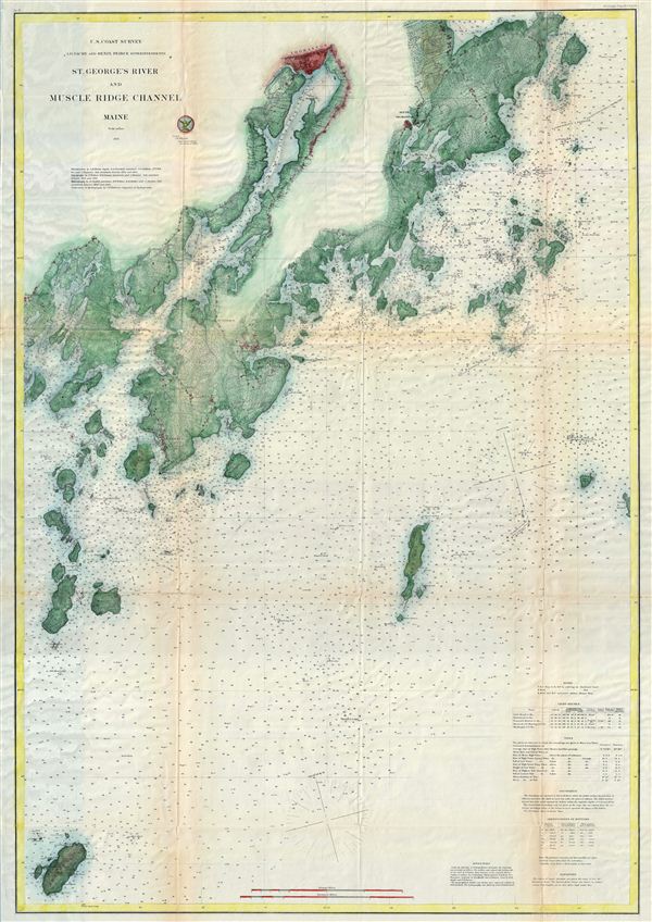
St. George River and Muscle Ridge Channel Maine.
1873 (dated) 39 x 27.5 in (99.06 x 69.85 cm)
1873 (dated) 39 x 27.5 in (99.06 x 69.85 cm)
Description
This is an appealing mid-19th century U.S. Coast Survey nautical chart or map of St. Georges River and Muscle Ridge Channel, Maine. The map covers the Maine coastline from Friendship Main eastward to Monroe Island, including Thomaston, South Thomaston, Herring Gut, Tennants Harbor, Harts Neck, and several other small communities. This chart offers some of the Coast Survey's earliest work in this region. The map features countless depth sounding and shading to indicated shoals and other undersea dangers. Sailing instructions and notes pertinent to the mariner appear in the lower right quadrant.
When this map was drawn the region was a center for shipbuilding and nautical commerce. By 1840 there were but seven recorded millionaires in the United States and two were Thomaston ship captains. Later in the 19th century the shipbuilding centers moved to other regions leaving Thomason a quiet and beautiful tourist haven.
The triangulation for this chart was accomplished A. D. Bache, G. A. Fairfield, J. A. Sullivan, e. e. Webber and C. Ferguson. The topography is the work of F. W. Corr, W. H. Dennis, and C. Hosmer. The hydrography was completed by a party under the command of e. Cordell, F. P. Webber, R. e. Halter and C. Junken. The whole was compiled under the supervision of A. D. Bache, one of the most influential and prolific figures in the early history of the U.S. Coast Survey.
Cartographer
The Office of the Coast Survey (1807 - present) founded in 1807 by President Thomas Jefferson and Secretary of Commerce Albert Gallatin, is the oldest scientific organization in the U.S. Federal Government. Jefferson created the "Survey of the Coast," as it was then called, in response to a need for accurate navigational charts of the new nation's coasts and harbors. The spirit of the Coast Survey was defined by its first two superintendents. The first superintendent of the Coast Survey was Swiss immigrant and West Point mathematics professor Ferdinand Hassler. Under the direction of Hassler, from 1816 to 1843, the ideological and scientific foundations for the Coast Survey were established. These included using the most advanced techniques and most sophisticated equipment as well as an unstinting attention to detail. Hassler devised a labor intensive triangulation system whereby the entire coast was divided into a series of enormous triangles. These were in turn subdivided into smaller triangulation units that were then individually surveyed. Employing this exacting technique on such a massive scale had never before been attempted. Consequently, Hassler and the Coast Survey under him developed a reputation for uncompromising dedication to the principles of accuracy and excellence. Unfortunately, despite being a masterful surveyor, Hassler was abrasive and politically unpopular, twice losing congressional funding for the Coast Survey. Nonetheless, Hassler led the Coast Survey until his death in 1843, at which time Alexander Dallas Bache, a great-grandson of Benjamin Franklin, took the helm. Bache was fully dedicated to the principles established by Hassler, but proved more politically astute and successfully lobbied Congress to liberally fund the endeavor. Under the leadership of A. D. Bache, the Coast Survey completed its most important work. Moreover, during his long tenure with the Coast Survey, from 1843 to 1865, Bache was a steadfast advocate of American science and navigation and in fact founded the American Academy of Sciences. Bache was succeeded by Benjamin Pierce who ran the Survey from 1867 to 1874. Pierce was in turn succeeded by Carlile Pollock Patterson who was Superintendent from 1874 to 1881. In 1878, under Patterson's superintendence, the U.S. Coast Survey was reorganized as the U.S. Coast and Geodetic Survey (C & GS) to accommodate topographic as well as nautical surveys. Today the Coast Survey is part of the National Oceanic and Atmospheric Administration or NOAA as the National Geodetic Survey. More by this mapmaker...
Source
Bache, A. D., Report of the Superintendent of the United States Coast Survey, Washington, 1873.
Condition
Very good. Blank on verso. Minor toning along folds. Verso repair near fold lines.