This item has been sold, but you can get on the Waitlist to be notified if another example becomes available, or purchase a digital scan.
1900 Heathcote Map of the St. Kilda Archipelago, Scotland
StKilda-heathcote-1900$87.50

Title
The Island of St. Kilda.
1900 (dated) 15.5 x 15.25 in (39.37 x 38.735 cm) 1 : 31680
1900 (dated) 15.5 x 15.25 in (39.37 x 38.735 cm) 1 : 31680
Description
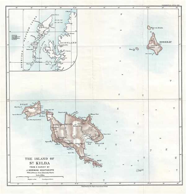
This is a 1900 John Norman Heathcote map of the St Kilda archipelago, the outermost islands of the Outer Hebrides of Scotland. The map depicts all four islands, which are Hirta (the largest), Dùn, Soay, and Boreray, along with an inset map in the upper left corner illustrating where the archipelago is situated in relation to mainland Scotland. Possibly the first printed specific map of this archipelago, St Kilda is now uninhabited. At the time of this map's creation, however, seventy people lived on Hirta. The archipelago was a popular tourist destination in the late 19th and early 20th century, with people visiting during the summer by steamer and private yachts. The entire population of Hirta (then numbering 36 people) was evacuated to mainland Scotland on August 29, 1930.
This map was published in the Geographical Journal by Heathcote with an article explaining the methods he used to survey the islands to create the map he included in his book, titled St. Kilda. The book evolved out of two visits Heathcote and his sister took to the island in 1898 and 1899 and details the people of St Kilda, their history and customs, along with the wildlife and his and his sister's experiences while visiting the islands.
This map was published in the Volume 15, No. 2 of the Geographical Journal in February, 1900.
CartographerS
John Norman Heathcote (June 21, 1863 - July 16, 1946) was a British author, watercolorist, and photographer, known for writing the book St Kilda about the Scottish Hebridean archipelago of St. Kilda, which was published in 1900. The second child of and eldest son of John Moyer Heathcoate (1834 - 1912) and Louisa Cecilia MacLeod (1838 - 1910), his father was a barrister and his mother was the eldest child of Norman MacLeod, 25th chief of Clan MacLeod. Heathcote attended Eton College and then Trinity College, from which he earned a BA degree in 1885. In 1906 he became a Justice of the Peace and served as High Sheriff of Huntingdonshire in 1917/18. He never married or had children. St Kilda, his best known work, was published in London in 1900, after he and his sister visited the archipelago in 1898 and 1899. He also published a journal article, ‘A Map of St Kilda’ in the Geographical Journal describing the surveying methods he used in producing the map that was included in the book. More by this mapmaker...
Royal Geographical Society (fl. 1830 - present) is a British Society established in 1830 to promote geographical science and exploration. Originally titled the "Geographical Society of London", the RGS received its royal charter from Queen Victoria in 1859 shortly after absorbing several similar but more regional societies including the African Association, the Raleigh Club and the Palestine Association. The RGS sponsored many of the most important and exciting voyages of exploration ever undertaken, including the exploration of Charles Darwin, David Livingstone, Robert Falcon Scott, Richard F. Burton, John Speke, George Hayward, H. M Stanley, Ernest Shackleton and Sir Edmond Hillary. Today, the RGS remains a leading global sponsor of geographical and scientific studies. The Society is based in Lowther Lodge, South Kensington, London. Learn More...
Source
The Geographical Journal Vol. XV, No. 2, February 1900.
Condition
Very good. Light wear along original fold lines. Light foxing. Blank on verso.
References
OCLC 316544422.