This item has been sold, but you can get on the Waitlist to be notified if another example becomes available, or purchase a digital scan.
1814 Thomson Map of the St. Lawrence River, Canada
StLawrenceRiver-thomson-1814$62.50

Title
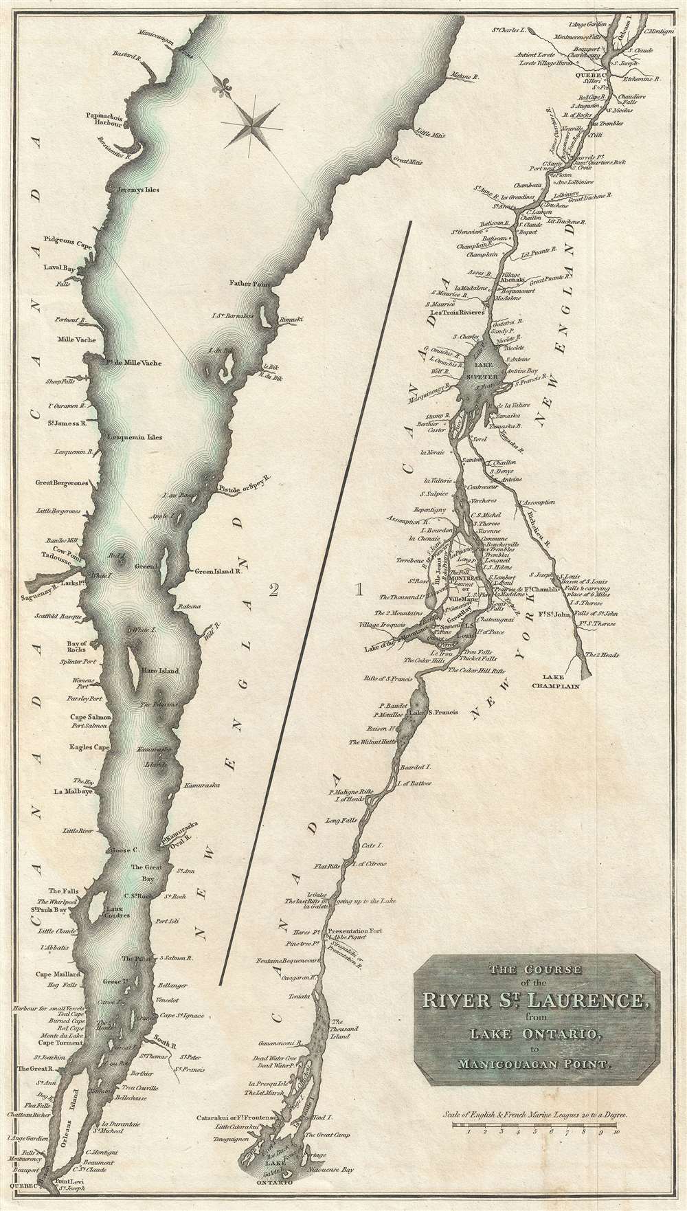
The Course of the River St. Laurence, from Lake Ontario to Manicouagan Point.
1814 (undated) 16.5 x 9.26 in (41.91 x 23.5204 cm) 1 : 1251500
1814 (undated) 16.5 x 9.26 in (41.91 x 23.5204 cm) 1 : 1251500
Description
A fine example of John Thomson's 1814 map of the St. Lawrence River from Lake Ontario to Manicouagan Point, Quebec, Canada. Divided into two sections, the left covers the river from Manicouagan Point to Quebec City while the right section continues along the course of the river from Quebec City to Lake Ontario. The Richelieu River, which connects the St. Lawrence to Lake Champlain is also included in this section. Includes both Quebec City and Montreal.
Riverine Detail
The St. Lawrence River was a critical artery for British Canada and remains an important shipping lane to this day. Thomson no doubt planned this map to capitalize on interest in the river in England spurred by events in the American Revolutionary War and the more recent War of 1812.Publication History
This is the first edition of Thomson's map from the 1814 edition of the General Atlas. Subsequent editions were published in 1817 and 1826.Cartographer
John Thomson (1777 - c. 1841) was a Scottish cartographer, publisher, and bookbinder active in Edinburgh during the early part of the 19th century. Thomson apprenticed under Edinburgh bookbinder Robert Alison. After his apprenticeship, he briefly went into business with Abraham Thomson. Later, the two parted ways, John Thomson segueing into maps and Abraham Thomson taking over the bookbinding portion of the business. Thomson is generally one of the leading publishers in the Edinburgh school of cartography, which flourished from roughly 1800 to 1830. Thomson and his contemporaries (Pinkerton and Cary) redefined European cartography by abandoning typical 18th-century decorative elements such as elaborate title cartouches and fantastic beasts in favor of detail and accuracy. Thomson's principle works include Thomson's New General Atlas, published from 1814 to 1821, the New Classical and Historical Atlas of 1829, and his 1830 Atlas of Scotland. The Atlas of Scotland, a work of groundbreaking detail and dedication, would eventually bankrupt the Thomson firm in 1830, at which time their plates were sequestered by the court. The firm partially recovered in the subsequent year, allowing Thomson to reclaim his printing plates in 1831, but filed again for bankruptcy in 1835, at which time most of his printing plates were sold to A. K. Johnston and Company. There is some suggestion that he continued to work as a bookbinder until 1841. Today, Thomson maps are becoming increasingly rare as they are highly admired for their impressive size, vivid hand coloration, and superb detail. More by this mapmaker...
Source
Thomson, J. A New General Atlas, (Edinburgh) 1814.
Condition
Very good. Some offsetting.
References
Rumsey 1007.061 (1817 edition). Newberry Library: Ayer 135 T4 1817 no. 55.