Digital Image: 1909 Suvorin City Map or Plan of St. Petersburg, Russia
StPetersburg-suvorin-1909_d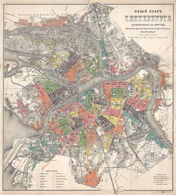

Title
ОБЩЙ ПЛАНЪ С. ПЕТЕРБУРГА. / Overall Plan S. Petersburg.
1909 (dated) 26.5 x 24 in (67.31 x 60.96 cm) 1 : 19550
1909 (dated) 26.5 x 24 in (67.31 x 60.96 cm) 1 : 19550
Description
FOR THE ORIGINAL ANTIQUE MAP, WITH HISTORICAL ANALYSIS, CLICK HERE.
Digital Map Information
Geographicus maintains an archive of high-resolution rare map scans. We scan our maps at 300 DPI or higher, with newer images being 600 DPI, (either TIFF or JPEG, depending on when the scan was done) which is most cases in suitable for enlargement and printing.
Delivery
Once you purchase our digital scan service, you will receive a download link via email - usually within seconds. Digital orders are delivered as ZIP files, an industry standard file compression protocol that any computer should be able to unpack. Some of our files are very large, and can take some time to download. Most files are saved into your computer's 'Downloads' folder. All delivery is electronic. No physical product is shipped.
Credit and Scope of Use
You can use your digial image any way you want! Our digital images are unrestricted by copyright and can be used, modified, and published freely. The textual description that accompanies the original antique map is not included in the sale of digital images and remains protected by copyright. That said, we put significant care and effort into scanning and editing these maps, and we’d appreciate a credit when possible. Should you wish to credit us, please use the following credit line:
Courtesy of Geographicus Rare Antique Maps (https://www.geographicus.com).
How Large Can I Print?
In general, at 300 DPI, you should at least be able to double the size of the actual image, more so with our 600 DPI images. So, if the original was 10 x 12 inches, you can print at 20 x 24 inches, without quality loss. If your display requirements can accommodate some loss in image quality, you can make it even larger. That being said, no quality of scan will allow you to blow up at 10 x 12 inch map to wall size without significant quality loss. For more information, it is best consult a printer or reprographics specialist.
Refunds
If the high resolution image you ordered is unavailable, we will fully refund your purchase. Otherwise, digital images scans are a service, not a tangible product, and cannot be returned or refunded once the download link is used.
Cartographer
Aleksei Sergeyevich Suvorin (September 11, 1834 - August 11, 1912) was an extremely influential Russian newspaper and book publisher, journalist, playwright and theater critic. The eldest of nine children (three boys and six girls), Suvorin attended the Mikhailovsky military academy in Voronezh, from which he graduated in 1851. He too retired from the military and became a schoolteacher, teaching history and geography near his hometown. In 1861 he moved to Moscow to work for the magazine 'Russian Speech' («Русской речи») and then moved to St. Petersburg in 1863 where he continued to write for several different magazines. He continued to rise through the ranks in the magazine and newspaper world in St. Petersburg, acquiring the newspaper Novoye Vremya ('New Times') in 1876 of which he remained the editor in chief until his death. Suvorin first entered the publishing world in 1872 when he published an edition of the «Русский календарь» ('Russian calendar') and published from the late 1890s until 1914 a guidebook to St. Petersburg entitled «Весь Петербург» ('All Petersburg') More by this mapmaker...