This item has been sold, but you can get on the Waitlist to be notified if another example becomes available, or purchase a digital scan.
1606 / 1613 Hondius Map of the Strait of Magellan
StraitMagellan-hondius-1606$700.00

Title
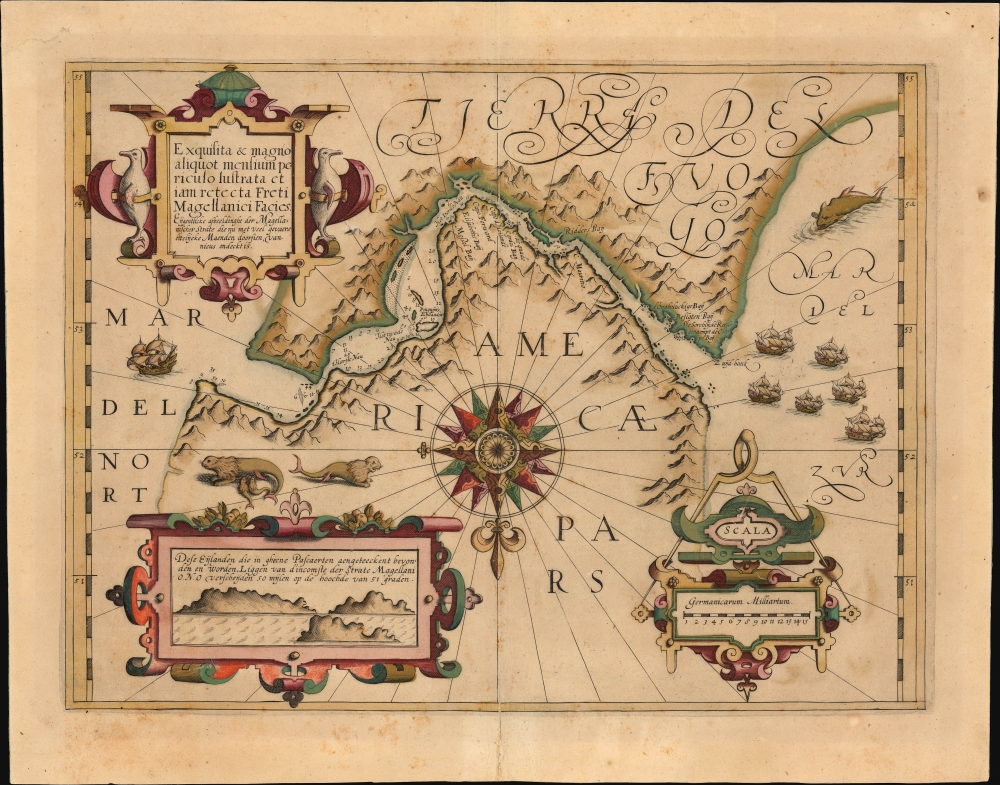
Exquisita et magno aliquot mensium periculo lustrata et jam retecta Freti Magellanici Facies.
1606 (undated) 13.5 x 18 in (34.29 x 45.72 cm) 1 : 17000000
1606 (undated) 13.5 x 18 in (34.29 x 45.72 cm) 1 : 17000000
Description
This is a beautiful, original-color example of Jodocus Hondius' 1606/1613 map of the Strait of Magellan. It is one of the earliest charts specifically of the Strait, which was the only known westward communication between the Atlantic and the Pacific oceans at the time of its printing. (Le Maire and Schouten did not discover the Cape Horn route until 1619.) With its abundant depictions of animals, ships, and the mountainous terrain - not to mention a superb compass rose - this is among Jodocus Hondius' most visually engaging maps.
A Closer Look
As is indicated by the grand, central compass rose, the chart is oriented to the south: the top of the map is dominated by the northern coasts of Tierra del Fuego, and the bottom of the map by the southern extreme of the American continent. To the left is the Mar del Nort, or the Atlantic Ocean; to the right is the Mar del Zur, or the Pacific. The Strait is marked with depth soundings, and about twenty placenames are noted along the coast. A ship at sail awaits entry to the passage at its Atlantic mouth; a flotilla of five ships sets off into the Pacific, menaced by a great sea monster. Sea lions bask on the Patagonian shore, and a pair of stately penguins flank the map's cartouche.Path of the Early Circumnavigations
The chart's copious depth soundings are derived from charts drawn by Jan Outghersz for his 1601 Nieuwe volmaeckte beschryvinghe der vervaerlijcker Strate Magellani. This work records Outghersz's experiences on the ill-fated 1598-1600 voyage with Sebald de Weert. The place names are largely his as well. However, some date from Thomas Cavendish's passage (Capo Forward, for example), and some of the placenames suggest Drake's passage (such as Elizabetjh's Bay.) Several can be traced to Outghersz's much more current expedition, however: Eerst Nau and Tweede Nau, C. Mauritio, Ridders Bay, Derde Nau, and Pinguijns Eylande.Early Glimpse of the Falkland Islands
An inset view to the lower left, with an elegant strapwork frame, depicts three islands in profile; the Dutch text describes them, 'These islands, which are not shown on any chart, lie at a distance of 50 miles East-North-East from the entrance of the Strait of Magellan, at the latitude of 51 degrees.' The distance is grossly wrong - it is closer to three hundred miles - but these islands were spotted by De Weert's expedition returning to the Netherlands from the Strait. These, first named the Sebalt de Weert Islands, then known as the Sebald Islands well into the 18th century, are now known as the Jason Islands and are part of the Falkland Islands archipelago.Publication History and Census
This map was engraved for the Hondius firm, probably initially as a separate issue. The present example is the second state. The extremely rare first state of 1606 featured text indicating that it was for sale by Dutch printer Zacharias Heyns. According to van der Krogt, the first state sometimes appeared in the first edition of Hondius' Gerardi Mercatoris Atlas sive Cosmographicae, but the 'Heyns' text was swiftly removed, and virtually all examples of this map are of the second state. (Interestingly, it was Heyns who published Outghersz's account of the Strait in 1601, so it is likely that the first state was intended as a companion piece?) The present example conforms typographically to the 1613 Latin text edition of the Hondius atlas. Both the atlas and separate examples of the map are well represented in institutional collections.CartographerS
Jodocus Hondius (October, 14 1563 - February 12, 1612) was an important Dutch cartographer active in the late 16th and early 17th centuries. His common name, Jodocus Hondius is actually a Latinized version of his Dutch name, Joost de Hondt. He is also sometimes referred to as Jodocus Hondius the Elder to distinguish him from his sons. Hondius was a Flemish artist, engraver, and cartographer. He is best known for his early maps of the New World and Europe, for re-establishing the reputation of the work of Gerard Mercator, and for his portraits of Francis Drake. Hondius was born and raised in Ghent. In his early years he established himself as an engraver, instrument maker and globe maker. In 1584 he moved to London to escape religious difficulties in Flanders. During his stay in England, Hondius was instrumental in publicizing the work of Francis Drake, who had made a circumnavigation of the world in the late 1570s. In particular, in 1589 Hondius produced a now famous map of the cove of New Albion, where Drake briefly established a settlement on the west coast of North America. Hondius' map was based on journal and eyewitness accounts of the trip and has long fueled speculation about the precise location of Drake's landing, which has not yet been firmly established by historians. Hondius is also thought to be the artist of several well-known portraits of Drake that are now in the National Portrait Gallery in London. In 1593, Hondius returned to Amsterdam, where he remained until the end of his life. In 1604, he purchased the plates of Gerard Mercator's Atlas from Mercator's grandson. Mercator's work had languished in comparison to the rival atlas, Theatrum Orbis Terrarum by Ortelius. Hondius republished Mercator's work with 36 additional maps, including several which he himself produced. Despite the addition of his own contributions, Hondius recognizing the prestige of Mercator's name, gave Mercator full credit as the author of the work, listing himself as the publisher. Hondius' new edition of Mercator revived the great cartographer's reputation and was a great success, selling out after a year. Hondius later published a second edition, as well as a pocket version called the Atlas Minor. The maps have since become known as the "Mercator/Hondius series". Between 1605 and 1610 Hondius was employed by John Speed to engrave the plates for Speed's The Theatre of the Empire of Great Britaine. Following Hondius' death in 1612, his publishing work in Amsterdam was continued by his widow and two sons, Jodocus II and Henricus. Later his family formed a partnership with Jan Jansson, whose name appears on the Atlasas co-publisher after 1633. Eventually, starting with the first 1606 edition in Latin, about 50 editions of the Atlas were released in the main European languages. In the Islamic world, the atlas was partially translated by the Turkish scholar Katip Çelebi. The series is sometimes called the 'Mercator/Hondius/Jansson' series because of Jansson's later contributions. Hondius' is also credited with a number of important cartographic innovations including the introduction of decorative map borders and contributions to the evolution of 17th century Dutch wall maps. The work of Hondius was essential to the establishment Amsterdam as the center of cartography in Europe in the 17th century. More by this mapmaker...
Jan Outghersz (fl. 1598 - 1600) was a Dutch mariner, pilot, and chartmaker. Despite nothing being known of his birth or death, he is an important figure: he was the author of the first reliable chart, with sailing directions, of the Strait of Magellan. He piloted Geloof, the flagship of Sebald de Weert, (1567 - 1603) on his abortive 1598 - 1600 attempted circumnavigation. Although the expedition passed through the Strait of Magellan, weather proved a constant foe and the flotilla lost 120 crew members to the weather and skirmishes with Patagonian natives. When Mauritius, commanded by Olivier van Noort, passed through the Strait, de Weert's survivors were so weak that they could not keep up with van Noort's fleet, and were forced to return to the Netherlands, arriving in 1600. Outghersz would publish his charts of the Strait with Zacharias Heyns the following year; Jodocus Hondius would incorporate these in a beautiful chart of the Strait in 1606. Learn More...
Source
Hondius, J., Atlas, (Amsterdam: Hondius) 1613.
Mercator's Atlas is one of the most important works in the history of cartography. Although in fact Ortelius was the first to publish a proper atlas, the Teatrum Orbis Terrarum, Mercator's work the first book to employ the term Atlas for a collection of maps. The term is derived both from the mythical titan, Atlas, who was forced to bear the world upon his shoulders, and the Libyan king, philosopher, and astronomer of the same name that, so the legend goes, constructed the first globe. Mercator dedicated the final 25 years of his life to compile the Atlas. He published two parts during his lifetime in 1585 and 1589, but the final part published posthumously by his son Rumold Mercator, in 1595. The map plates for the Atlas were later acquired by Jodocus Hondius who published the most complete and well known edition in 1606. It was Jodocus who popularized the Atlas and who did the most to elevate Gerard Mercator's name.
Condition
Very good. Mend to bottom centerfold with no loss. Original hand color.
References
OCLC 224109897. Rumsey 10501.517 (1607) Van der Krogt, P. C. J., Koeman's Atlantes Neerlandici, (Vol 1), 9950:1A.2.