This item has been sold, but you can get on the Waitlist to be notified if another example becomes available, or purchase a digital scan.
1845 Haskell / Colton Chart of Time from Creation to 1845
StreamofTime-colton-1845$900.00

Title
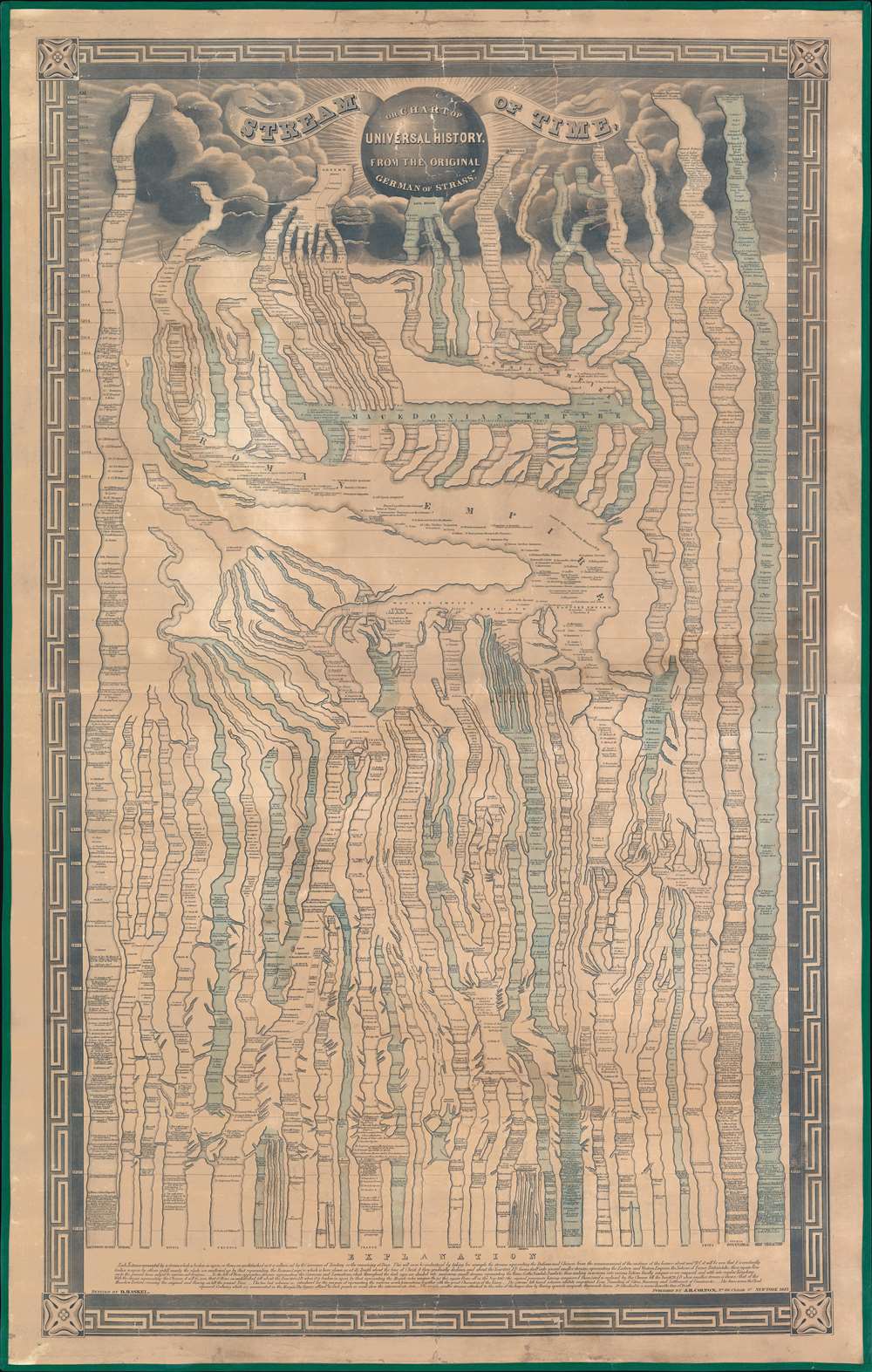
Stream of Time or Chart of universal history, from the original German of Strass.
1845 (dated) 48.5 x 30.75 in (123.19 x 78.105 cm)
1845 (dated) 48.5 x 30.75 in (123.19 x 78.105 cm)
Description
A remarkable 1845 chart of world history covering the passage of time from creation (4004 BC) to roughly 1845.
A Closer Look
This chart applies the metaphor of a stream to the passage of time. Time is here divided into great channels, representing the great civilizations of antiquity: Greece, Rome, Assyria, China, Egypt, Jews, etc. Additional broader channels record 'Inventions, Discoveries, Remarkable Events', 'Great Characters' (Essentially the 'begats'), and the 'Eras Founding of Cities Discovery and Settlement of Countries.' Despite its ties to outdated Biblical thinking, the chart has much to offer, placing often seemingly disconnected historical events into a global context. Note for example the outsized influence of the great historical empires in consolidating and refining disparate timelines - the Roman Empire, for example, takes the form of a great sea into which most timelines of antiquity flow. As the chart moves into the modern era, it get exponentially more complex, with new timelines (the Germans, Samaritans, Norwegians, and Hungarians for example) entering the fray.Explained by the Creator
At the bottom of the map, on the left, the author Daniel Haskel (1784 - 1848) describes the chart,Each Nation is represented by a stream which is broken in upon or flows undisturbed as it is influenced by the accession of Territory or the reaming at peace. This will soon be understood by taking for example, the streams representing the Italians and Chinese, from the commencement of the existence of the former about 1900 BC, it will be seen that it is constantly broken in upon by others until nearly the whole are swallowed up by that representing the Roman Empire; which is here shewn at its Zenith around the time of Christ, it then gradually declines, and about the year 400 AD forms itself into several smaller streams, representing the Eastern and Western Empires, the Nations of France, Britain etc. these again flow on to the present time, subject to various subdivisions…
Strom der Zeiten
The chart follows on a chart first issued in 1804 by Friedrich Strass as Strom der Zeiten. Strauss was influenced by Joseph Priestly, an English natural philosopher, who advocated for a graphic rather than annalistic representation of history. Anthony Grafton and Daniel Rosenberg, in their Cartographies of Time: A History of the Timeline, describe how time on such charts 'ebbs and flows, forks and twists, runs and rolls and thunders.' The original work proved extremely popular and was immediately translated into multiple languages. The theme was also applied to other timelines, such as Emma Willard's 1826 Picture of Nations.Publication History and Census
Following the issue of the 1804 Strauss edition of Strom der Zeiten, the chart was copied extensively by other publishers, many of whom added updates and revisions, making it their own. Colton, working with Daniel Haskel (1784 - 1848), published editions in 1842 and 1845, then with Richard Swainson Fisher in 1860 and 1866. Rare. The OCLC notes a single example of the 1860 Colton Edition, one 1842, one 1845 (as here), and one 1866. We are aware of two examples of the 1866 in private hands.CartographerS
Daniel Haskel (June 1784 - August 9, 1848) was an American scholar, reverent, and university administrator active in New England in the first half of the 19th century. Haskell was born in Preston, Connecticut. He studied in Yale, graduating in 1802. He went on to study theology at Princeton before, in 1810, accepting the pastorate of the First Calvinistic Congregational Society in Burlington, Vermont. In 1821, he became the third president of the University of Vermont, a position he held until 1824. More by this mapmaker...
Joseph Hutchins Colton (July 5, 1800 - July 29, 1893), often publishing as J. H. Colton, was an important American map and atlas publisher active from 1833 to 1897. Colton's firm arose from humble beginnings when he moved to New York in 1831 and befriended the established engraver, Samuel Stiles. He worked under Stiles as the 'Co.' in Stiles and Co. from 1833 to 1836. Colton quickly recognized an emerging market in railroad maps and immigrant guides. Not a cartographer or engraver himself, Colton's initial business practice mostly involved purchasing the copyrights of other cartographers, most notably David H. Burr, and reissuing them with updated engraving and border work. His first maps, produced in 1833, were based on earlier Burr maps and depicted New York State and New York City. Between 1833 and 1855, Colton proceeded to publish a large corpus of guidebooks and railroad maps, which proved popular. In the early 1850s, Colton brought his two sons, George Woolworth Colton (1827 - 1901) and Charles B. Colton (1832 - 1916), into the map business. G. W. Colton, trained as a cartographer and engraver, was particularly inspired by the idea of creating a large and detailed world atlas to compete with established European firms for the U.S. market. In 1855, G.W. Colton issued volume one of the impressive two-volume Colton's Atlas of the World. Volume two followed a year later. Possibly because of the expense of purchasing a two-volume atlas set, the sales of the Atlas of the World did not meet Colton's expectations, and so, in 1856, the firm also issued the atlas as a single volume. The maps contained in this superb work were all original engravings, and most bear an 1855 copyright. All of the maps were surrounded by an attractive spiral motif border that would become a hallmark of Colton's atlas maps well into the 1880s. In 1857, the slightly smaller Colton's General Atlas replaced the Atlas of the World. Most early editions of the General Atlas published from 1857 to 1859 do not have the trademark Colton spiral border, which was removed to allow the maps to fit into a smaller format volume. Their customers must have missed the border because it was reinstated in 1860 and remained in all subsequent publications of the atlas. There were also darker times ahead; in 1858, Colton was commissioned at a sum of 25,000 USD by the government of Bolivia to produce and deliver 10,000 copies of a large format map of that country. Although Colton completed the contract in good faith, delivering the maps at his own expense, he was never paid by Bolivia, which was at the time in the midst of a series of national revolutions. Colton would spend the remainder of his days fighting with the Bolivian and Peruvian governments over this payment, and in the end, after a congressional intervention, he received as much as 100,000 USD in compensation. Nonetheless, at the time, it was a disastrous blow. J. H. Colton and Company is listed as one of New York's failed companies in the postal record of 1859. This led Colton into the arms of Alvin Jewett Johnson and Ross C. Browning. The 1859 edition of Colton's General Atlas lists Johnson and Browning as the 'Successor's to J. H. Colton' suggesting an outright buyout, but given that both companies continued to publish separately, the reality is likely more complex. Whatever the case may have been, this arrangement gave Johnson and Browning access to many of Colton's map plates and gave birth to Johnson's New Illustrated (Steel Plate) Family Atlas. The Johnson's Atlas was published parallel to Colton's atlases well into the 1880s. The Colton firm itself subsequently published several other atlases including an Atlas of America, the Illustrated Cabinet Atlas, the Octavo Atlas of the Union, and Colton's Quarto Atlas of the World. They also published a large corpus of wall maps, pocket maps, and guides. The last known publications of the Colton firm date to 1897 and include a map and a view, both issued in association with the Merchant's Association of New York. Alice M. Colton married August R. Ohman (May 3, 1859 - April 22, 1934) on January 5, 1897. In 1898, Ohman joined the Colton firm, which continued to publish as Colton, Ohman & Co. until 1901. Learn More...
Condition
Good. Overall toning. Relaid on fresh linen with fresh edging. Varnish layer removed.
References
Rumsey 1704.000 (1842). OCLC 191233581. Grafton. A., and Rosenberg, D., Cartographies of Time: A History of the Timeline, pp. 143, 144 - 45, 147. Schulten, S., Mapping the Nation, pp. 31 - 33. Schulten, 'Emma Willard and the graphic foundations of American history.'